Sëlva
| Sëlva | |
|---|---|
| Comune | |
| Chemun de Sëlva Comune di Selva di Val Gardena Gemeinde Wolkenstein in Gröden | |
 | |
 Sëlva Location of Sëlva in Italy | |
| Coordinates: 46°33′N 11°46′E / 46.550°N 11.767°ECoordinates: 46°33′N 11°46′E / 46.550°N 11.767°E | |
| Country | Italy |
| Region | Trentino-Alto Adige/Südtirol |
| Province / Metropolitan city | South Tyrol (BZ) |
| Frazioni | Plan |
| Government | |
| • Mayor | Rolando Demetz (SVP) |
| Area | |
| • Total | 53.2 km2 (20.5 sq mi) |
| Elevation | 1,563 m (5,128 ft) |
| Population (Nov. 2010) | |
| • Total | 2,637 |
| • Density | 50/km2 (130/sq mi) |
| Demonym(s) |
Ladin: salvans Italian: gardenesi German: Wolkensteiner |
| Time zone | CET (UTC+1) |
| • Summer (DST) | CEST (UTC+2) |
| Postal code | 39048 |
| Dialing code | 0471 |
| Website | Official website |
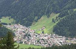
Sëlva (![]() [ˈsɜlva] ; Italian: Selva di Val Gardena [ˈselva di val ɡarˈdeːna]; German: Wolkenstein in Gröden [ˈwɔlkn̩ʃtaɪ̯n ɪn ˈɡrøːdn̩]) is a comune (municipality) in the Val Gardena in South Tyrol, northern Italy, located about 30 kilometres (19 mi) east of the city of Bolzano. The Ladin place name derives from the Latin word silva ("wood").
[ˈsɜlva] ; Italian: Selva di Val Gardena [ˈselva di val ɡarˈdeːna]; German: Wolkenstein in Gröden [ˈwɔlkn̩ʃtaɪ̯n ɪn ˈɡrøːdn̩]) is a comune (municipality) in the Val Gardena in South Tyrol, northern Italy, located about 30 kilometres (19 mi) east of the city of Bolzano. The Ladin place name derives from the Latin word silva ("wood").
Geography
As of 30 December 2010, it had a population of 2,637 and an area of 53.2 square kilometres (20.5 sq mi).[1] Sëlva borders the following municipalities: Badia, Campitello di Fassa, Canazei, Corvara, San Martin de Tor, and Santa Cristina Gherdëina.
It is perhaps best known as one of the starting points of the Sella Ronda ski tour.
History
Coat-of-arms
The emblem is quarterly, the first and third corners are per bend and per fess nebuly of argent and gules; the second and third corners are indented of azure and argent on a sable top. The emblem represents the insignia of the Lords of Wolkenstein who built the local castle in 1291. The emblem was adopted in 1968.[2]
Society
Linguistic distribution
According to the 2011 census, 89.74% of the population speak Ladin, 5.11% Italian and 5.15% German as first language.[3]
Demographic evolution

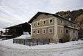 The farmhouse Piciulëi in Sëlva Gherdëina. Southern aspect
References
- ↑ All demographics and other statistics: Italian statistical institute Istat.
- ↑ Heraldry of the World: Sëlva
- ↑ "Volkszählung 2011/Censimento della popolazione 2011". astat info. Provincial Statistics Institute of the Autonomous Province of South Tyrol (38): 6–7. June 2012. Retrieved 2012-06-14.
External links
![]() Media related to Sëlva at Wikimedia Commons
Media related to Sëlva at Wikimedia Commons
- (Italian) (German) Homepage of the municipality
