SM City Marikina
|
Mall Logo | |
| Location | Calumpang, Marikina, Philippines |
|---|---|
| Opening date | September 5, 2008 |
| Developer | SM Prime Holdings and BF Construction Corporation |
| Management | SM Prime Holdings |
| Owner | Henry Sy, Sr. |
| No. of stores and services | 400+ |
| No. of anchor tenants | 12 |
| Total retail floor area | 124,878 m2 (1,344,180 sq ft) |
| No. of floors | 5 |
| Parking | 2,000+ slots |
| Public transit access | Light Rail Transit: LRT-2 via Santolan Station |
| Website | SM City Marikina |
SM City Marikina is a shopping mall owned and managed by SM Prime Holdings, and is located in Calumpang, Marikina, Philippines. SM Supermalls is owned by Henry Sy, Sr. SM City Marikina opened in 2008.
Upon completion in 2008, it is the 31st SM Supermall built in the Philippines, 14th SM Mall built within Metro Manila, and 3rd among other SM malls opened in the eastern region of Metropolitan Manila, after SM Megamall in Mandaluyong City and SM Center Pasig in Pasig City.
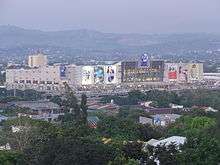
SM City Marikina is located near Marikina River and Riverbanks Center. It is situated along Marcos Highway (Radial Road-6 or R6), Barangay Calumpang, Marikina City. This mall has a total of 60,000 square meter land area and a total of 124,877.85 square meter gross floor area, consider as one of the largest structures in Marikina valley.
SM City Marikina was opened to the public on September 5, 2008, with opening ceremonies and ribbon cutting headed by then MMDA Chairman Bayani Fernando, and his wife, then Marikina City Mayor Marides Fernando and other city officials, as well as the owner of SM Prime Holdings Henry Sy, and SM executives.
History
The mall began its plans in 2006 when Henry Sy bought an estimated 120,000 square meter lot that was owned by Bayani Fernando which was supposed to become an amusement park called Fun Pamilya. Construction began on early 2006. SM Prime Holdings and BF Construction Corporation are the developers of the mall.
The mall's structures utilized strong vertical tubes, enabling the mall to support the upper levels (Basement 1 up to top floors) from its ground area (Basement 2). It also has new bridges (branching towards Marcos Highway) surrounding the establishment. The mall's main entrance is located at the 3rd level of the building (1st floor of the mall) to be at par with Marcos Highway's high elevation, and to minimize if not prevent damage to the structure and the mall itself during flooding.
Location
SM City Marikina is located beside the Marikina River and Riverbanks Center and situated along Marcos Highway, Barangay Calumpang, Marikina City. The location of the mall is accessible through different modes of public transport such as jeepneys, buses, AUVs, and taxis as well as train via LRT-2 Santolan Station. There are also specialized bridges branching out to and from Marcos Highway bridge which all vehicles from Antipolo City going to Quezon City can directly access the mall. It also has an interchange beneath the Marcos Highway bridge, allowing all vehicles to easily access the different points of Metro Manila, like those en route to NAIA, Makati City, Ortigas Center, Bonifacio Global City and Eastwood City. SM City Marikina is near in many residential areas and its easily recognize structure in the area.
Mall features
SM City Marikina's is one of the largest building structures in Marikina. The mall features a five-level building (three upper floors function as the mall area and 2 lower floors serve as the indoor parking lots). It has a grand entrance, high ceilings and interplay of glass and steel, with modern Asian touches. Interiors have spacious areas with multicolored lighted ceilings with circle accents.
It has more than a thousand parking slots including provisions for motorcycle parking, a jeepney terminal for commuters, a 4-meter wide pedestrian overpass to and from the main mall area to the Santolan LRT station and another 2.40-meter-wide overpass to the Bus Bay 2 area.
See also
- SM City Masinag
- SM City San Mateo
- SM City Taytay
- SM Center Angono
- Riverbanks Center
- Sta. Lucia East Grandmall
- Robinsons Place Metro East
External links
- SM City Marikina. SM City Marikina Website
- SM City Marikina on Facebook
| Preceded by SM Center Muntinlupa |
31st SM Supermall 2008 |
Succeeded by SM City Rosales |
Coordinates: 14°37′39″N 121°05′04″E / 14.6275181°N 121.0843778°E