Sabha District
| Sabha (سبها) | |
| District | |
 | |
| Country | |
|---|---|
| Capital | Sabha |
| Area | 15,330 km2 (5,919 sq mi) |
| Population | 134,162 (2006) [1] |
| Density | 9/km2 (23/sq mi) |
 Map of Libya with Sabha district highlighted | |
Sabha (Arabic: سبها Sabhā) is one of the districts of Libya. It is located near the center of the country, in the Fezzan region. The capital is the city of Sabha. Sabha District borders the following districts, namely, Wadi Al Shatii in north, Al Jufrah in east, Murzuq in south and Wadi Al Hayaa in the west.
Per the census of 2012, the total population in the region was 157,747. The average size of the household in the country was 6.9. There were totally 22,713 households in the district, with 20,907 Libyan ones. The population density of the district was 1.86 persons per sq. km.
Geography
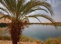
Sabha District borders the following districts, namely, Wadi Al Shatii in north, Al Jufrah in east, Murzuq in south and Wadi Al Hayaa in the west. Sabha District is in the Fezzen region (Libyan Desert), a section of the Sahara Desert. The Sabha Air Base is in the district. The Gaberoun oasis, on a spring fed lake, is a popular tourist attraction in the district. Libya has mostly a flat undulating plain and occasional plateau, with an average elevation of around 423 m (1,388 ft). Around 91 per cent of the land is covered by desert, with only 8.8 per cent agricultural land (with only 1 % arable lands) and 0.1 per cent of forests. The climate is desert in most parts of the district. Dust storms lasting four to eight days is pretty common during Spring.[2] Triplotania is the northwest region, while it is Cyrenacia in the east and Fezzen in southwest.[3] Fezzen is mostly full of deserts. The region receives an annual rainfall of 2.5 in (64 mm). There are no perennial rivers in the region, but the region is abundant with groundwater aquifers.[4]
Demographics
Per the census of 2012, the total population in the region was 157,747 with 150,353 Libyans. The average size of the household in the country was 6.9, while the average household size of non-Libyans being 3.7. There were totally 22,713 households in the district, with 20,907 Libyan ones. The population density of the district was 1.86 persons per sq. km. Per 2006 census, there were totally 43,010 economically active people in the district. There were 18,172 government employees, 5,114 employers, 16,974 first level workers and 001 second level workers. There were 8,114 workers in state administration, 6,733 in agriculture, animal husbandary and forestry, 7,341 in agriculutre & hunting, 7,931 in education, 3,840 in private enterprises, 1,340 in health & social work, 2,277 in production, 8,395 in technical work and 905 service workers. The total enrollment in schools was 45,581 and the number of people above secondary stage and less than graduation was 2,529.[5] As per the report from World Health Organization (WHO), there were one communicable disease centres, 12 dental clinics, one general clinics, four in-patient clinics, seven out-patient clinics, 57 pharmacies, 25 PHC centres and one polyclinic.[6]
Politics
The major settlements of Sabha District include Sabha, Samnu, Tamanhant, Umm al `Abid, Umm al Ahrar and Al Mahdia. Libya became independent in 1951 from the colonial empire and generally known for its oil rich resources.[7] As a part of decentralization in 2012, the country is administratively split into 13 regions from the original 25 municipalities, which were further divided in 1,500 communes.[8] As of 2016, there were 22 administrative divisions in the country in the form of districts.[2] In the Libyan Civil War, Gaddafi forces maintained control of large parts of the district and city longer than elsewhere in the country. The National Transitional Council took control of the city on 11 September 2011.[9]
References
- ↑ "Districts of Libya". statoids.com. Retrieved 27 October 2009.
- 1 2 "Libya profile". 2016. Retrieved 23 November 2016.
- ↑ Otman, Waniss; Karlberg, Erling (2007). The Libyan Economy: Economic Diversification and International Repositioning. Springer Science & Business Media,. pp. 1–3. ISBN 9783540464631.
- ↑ McColl, R. W. (2014). Encyclopedia of World Geography, Volume 1. Infobase Publishing. p. 543. ISBN 9780816072293.
- ↑ "Census of Libya". General Information Authority, Libya. 2012. Retrieved 17 November 2016.
- ↑ "Health statistics of Libya". World Health Organization (WHO). 2007. Retrieved 17 November 2016.
- ↑ "Libya profile - Timeline". BBC. 2 August 2016. Retrieved 20 November 2016.
- ↑ Great Socialist People's Libyan Arag Jamahiriya Public Administration and Country profile (PDF) (Report). Department of Economic and Social Affairs (DESA), United Nations. 2004. p. 9. Retrieved 17 November 2016.
- ↑ BBC News "Libya conflict: Anti-Gaddafi fighters take Sabha" - accessed 23 September 2011.
External links
Coordinates: 27°02′N 14°26′E / 27.033°N 14.433°E
| Capital | ||
|---|---|---|
| Towns and villages |
| |