Wadi al Hayaa District
| Wadi Al Hayaa (وادي الحياة) | |
| District | |
 | |
| Country | |
|---|---|
| Capital | Ubari |
| Area | 31,890 km2 (12,313 sq mi) |
| Population | 76,858 (2006) [1] |
| Density | 2/km2 (5/sq mi) |
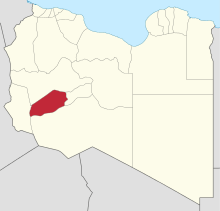 Map of Libya with Wadi Al Hayaa district highlighted | |
Wadi al Hayaa (Arabic: وادي الحياة Wādī al Ḥayāh) is one of the districts of Libya. Its capital is the city of Ubari. As of 2006, it had a population of 72,587, area of 31,890 sq.km and population density of 2.28 persons per sq. km.
The district is bordered by Wadi al Shatii in north, Sabha in east, Murzuq in south and Ghat in the west. The district is part of Fezzen geographical division of Libya which is mostly desert.
Geography
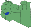
The district is bordered by Wadi al Shatii in north, Sabha in east, Murzuq in south and Ghat in the west. The district is part of Fezzen geographical division of Libya which is mostly full of deserts. The region receives an annual rainfall of 2.5 in (64 mm). There are no perennial rivers in the region, but the region is abundant with groundwater aquifers.[2] Libya has mostly a flat undulating plain and occasional plateau, with an average elevation of around 423 m (1,388 ft). Around 91 per cent of the land is covered by desert, with only 8.8 per cent agricultural land (with only 1 % arable lands) and 0.1 per cent of forests. The major resources found in the area is managanese. Along the coastal regions, the climate is Mediterranean, while it is desert climate in all other parts. Dust storms lasting four to eight days is pretty common during Spring.[3] Triplotania is the northwest region, while it is Cyrenacia in the east and Fezzen in southwest.[4]
Demographics
Per the census estimates of 2012, the total population in the region was 157,747 with 150,353 Libyans. The average size of the household in the country was 6.9, while the average household size of non-Libyans being 3.7. There were totally 22,713 households in the district, with 20,907 Libyan ones. The population density of the district was 1.86 persons per sq. km. Per 2006 census, there were totally 27,322 economically active people in the district. There were 14,650 government employees, 2,644 employers, 8,994 first level workers and 001 second level workers. There were 6,526 workers in state administration, 3,998 in agriculture, animal husbandary and forestry, 4,252 in agriculture & hunting, 6,511 in education, 2,226 in private enterprises, 1,419 in health & social work, 1,267 in production, 5,817 in technical work and 321 service workers. The total enrollment in schools was 26,890 and the number of people above secondary stage and less than graduation was 1,494.[5] As per the report from World Health Organization (WHO), there were no communicable disease centres, two dental clinics, two out-patient clinics, 16 pharmacies, 36 PHC centres, one rural clinics and no specialized clinics.[6]
References
- ↑ "Districts of Libya". statoids.com. Retrieved 27 October 2009.
- ↑ McColl, R. W. (2014). Encyclopedia of World Geography, Volume 1. Infobase Publishing. p. 543. ISBN 9780816072293.
- ↑ "Libya profile". 2016. Retrieved 23 November 2016.
- ↑ Otman, Waniss; Karlberg, Erling (2007). The Libyan Economy: Economic Diversification and International Repositioning. Springer Science & Business Media,. pp. 1–3. ISBN 9783540464631.
- ↑ "Census of Libya". General Information Authority, Libya. 2012. Retrieved 17 November 2016.
- ↑ "Health statistics of Libya". World Health Organization (WHO). 2007. Retrieved 17 November 2016.
External links
| Wikimedia Commons has media related to Wadi al Hayaa District. |
Coordinates: 26°15′N 12°30′E / 26.250°N 12.500°E