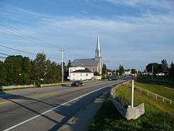
Sacré-Coeur, Quebec
| Sacré-Coeur | |
|---|---|
| Municipality | |
 | |
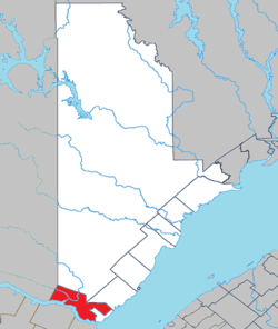 Location within La Haute-Côte-Nord RCM. | |
 Sacré-Coeur Location in Côte-Nord region of Quebec. | |
| Coordinates: 48°14′N 69°48′W / 48.233°N 69.800°WCoordinates: 48°14′N 69°48′W / 48.233°N 69.800°W[1] | |
| Country |
|
| Province |
|
| Region | Côte-Nord |
| RCM | La Haute-Côte-Nord |
| Constituted | June 13, 1973 |
| Government[2] | |
| • Mayor | Gilles Pineault |
| • Federal riding |
Montmorency—Charlevoix —Haute-Côte-Nord |
| • Prov. riding | René-Lévesque |
| Area[2][3] | |
| • Total | 339.90 km2 (131.24 sq mi) |
| • Land | 306.98 km2 (118.53 sq mi) |
| Population (2011)[3] | |
| • Total | 1,881 |
| • Density | 6.1/km2 (16/sq mi) |
| • Pop 2006-2011 |
|
| • Dwellings | 836 |
| Time zone | EST (UTC−5) |
| • Summer (DST) | EDT (UTC−4) |
| Postal code(s) | G0T 1Y0 |
| Area code(s) | 418 and 581 |
| Highways |
|
| Website |
www sacre-coeur |
Sacré-Coeur is a municipality in the Côte-Nord region of the province of Quebec in Canada.
Demographics
Population trend:[4]
- Population in 2011: 1881 (2006 to 2011 population change: -7.1 %)
- Population in 2006: 2024
- Population in 2001: 2053
- Population in 1996: 2081
- Population in 1991: 1992
Private dwellings occupied by usual residents: 745 (total dwellings: 836)
Mother tongue:
- English as first language: 0%
- French as first language: 99.5%
- English and French as first language: 0%
- Other as first language: 0.5%
See also
References
- ↑ Reference number 55394 of the Commission de toponymie du Québec (French)
- 1 2 Ministère des Affaires municipales, des Régions et de l'Occupation du territoire - Répertoire des municipalités: Sacré-Coeur
- 1 2 "Population and dwelling counts, for Canada, provinces and territories, and census subdivisions (municipalities), 2011 and 2001 censuses - 100% data". Statistics Canada, 2011 Census of Population. 2007-03-13. Retrieved 2007-07-20.
- ↑ Statistics Canada: 1996, 2001, 2006, 2011 census
External links
![]() Media related to Sacré-Coeur (Québec) at Wikimedia Commons
Media related to Sacré-Coeur (Québec) at Wikimedia Commons
 |
Lac-au-Brochet | Les Bergeronnes | | |
| Mont-Valin | |
Tadoussac | ||
| ||||
| | ||||
| Saguenay River / Petit-Saguenay, Baie-Sainte-Catherine |
| Cities & Towns | |
|---|---|
| Municipalities | |
| Villages | |
| Unorganized Territories | |
| Native reserves (Unassociated with RCM) | |
| |
This article is issued from Wikipedia - version of the 2/24/2014. The text is available under the Creative Commons Attribution/Share Alike but additional terms may apply for the media files.