Saginaw Township South, Michigan
| Saginaw Township South, Michigan | |
|---|---|
| CDP | |
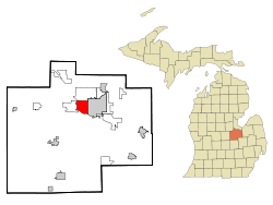 Location of Saginaw Township South within Saginaw County, Michigan | |
 Saginaw Township South, Michigan Location within the state of Michigan | |
| Coordinates: 43°25′02″N 84°01′09″W / 43.41722°N 84.01917°WCoordinates: 43°25′02″N 84°01′09″W / 43.41722°N 84.01917°W | |
| Country | United States |
| State | Michigan |
| County | Saginaw |
| Township | Saginaw Charter Township |
| Area | |
| • Total | 7.0 sq mi (18.2 km2) |
| • Land | 6.9 sq mi (17.9 km2) |
| • Water | 0.1 sq mi (0.4 km2) |
| Population (2000) | |
| • Total | 13,801 |
| • Density | 1,999.1/sq mi (771.8/km2) |
| Time zone | Eastern (EST) (UTC-5) |
| • Summer (DST) | EDT (UTC-4) |
| FIPS code | 26-70550[1] |
| GNIS feature ID | 2393219[2] |
Saginaw Township South is a census-designated place (CDP) in Saginaw County in the U.S. state of Michigan. The CDP is defined for statistical purposes and has no legal status as an incorporated municipality. The population was 13,801 at the 2000 census. The CDP is located within Saginaw Charter Township and consists of the township south of State St., while Saginaw Township North is most of the area north of State St. This division is purely for statistical purposes and does not reflect any present or historical self-identification of the residents in these areas.
Geography
According to the United States Census Bureau, the CDP has a total area of 7.0 square miles (18 km2), of which 6.9 square miles (18 km2) is land and 0.1 square miles (0.26 km2) (1.99%) is water.
Demographics
As of the census[1] of 2000, there were 13,801 people, 6,079 households, and 3,860 families residing in the CDP. The population density was 1,999.1 per square mile (772.3/km²). There were 6,327 housing units at an average density of 916.5/sq mi (354.0/km²). The racial makeup of the CDP was 89.86% White, 5.36% Black or African American, 0.25% Native American, 1.96% Asian, 0.01% Pacific Islander, 1.26% from other races, and 1.30% from two or more races. Hispanic or Latino of any race were 4.41% of the population.
There were 6,079 households out of which 26.0% had children under the age of 18 living with them, 52.7% were married couples living together, 8.5% had a female householder with no husband present, and 36.5% were non-families. 32.0% of all households were made up of individuals and 15.0% had someone living alone who was 65 years of age or older. The average household size was 2.27 and the average family size was 2.88.
In the CDP the population was spread out with 21.8% under the age of 18, 7.6% from 18 to 24, 25.0% from 25 to 44, 26.8% from 45 to 64, and 18.8% who were 65 years of age or older. The median age was 42 years. For every 100 females there were 90.1 males. For every 100 females age 18 and over, there were 86.8 males.
The median income for a household in the CDP was $48,605, and the median income for a family was $64,137. Males had a median income of $49,977 versus $30,968 for females. The per capita income for the CDP was $28,012. About 4.8% of families and 6.0% of the population were below the poverty line, including 6.6% of those under age 18 and 6.7% of those age 65 or over.
References
Municipalities and communities of Saginaw County, Michigan, United States | ||
|---|---|---|
| Cities | 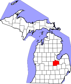 | |
| Villages | ||
| Charter townships | ||
| General law townships | ||
| CDPs | ||
| Other communities |
| |
| Footnotes | ‡This populated place also has portions in an adjacent county or counties | |