Saint Bernard, Louisiana
| Saint Bernard, Louisiana | |
|---|---|
| Unincorporated community | |
|
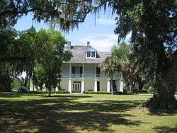
The Kenilworth Plantation House in Saint Bernard | |
 Saint Bernard, Louisiana  Saint Bernard, Louisiana | |
| Coordinates: 29°52′02″N 89°51′31″W / 29.86722°N 89.85861°WCoordinates: 29°52′02″N 89°51′31″W / 29.86722°N 89.85861°W | |
| Country | United States |
| State | Louisiana |
| Parish | St. Bernard |
| Elevation | 3 ft (0.9 m) |
| Time zone | Central (CST) (UTC-6) |
| • Summer (DST) | CDT (UTC-5) |
| Area code(s) | 504 |
| GNIS feature ID | 1628099[1] |
Saint Bernard is an unincorporated community in St. Bernard Parish, Louisiana, United States. The community is located on Louisiana State Highway 300 east of the Mississippi River and 8 miles (13 km) southeast of Chalmette.
Saint Bernard is home to four sites on the National Register of Historic Places: the Dr. Louis A. Ducros House, the Kenilworth Plantation House, Magnolia Mound, and the Sebastopol Plantation House.[2]
References
- ↑ "Saint Bernard". Geographic Names Information System. United States Geological Survey.
- ↑ National Park Service (2010-07-09). "National Register Information System". National Register of Historic Places. National Park Service.
Municipalities and communities of St. Bernard Parish, Louisiana, United States | ||
|---|---|---|
| CDPs | 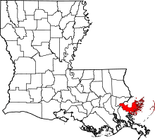 | |
| Unincorporated communities |
| |
| Ghost towns | ||
This article is issued from Wikipedia - version of the 7/31/2016. The text is available under the Creative Commons Attribution/Share Alike but additional terms may apply for the media files.