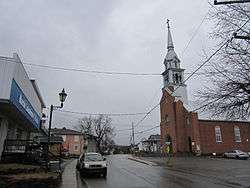
Sainte-Béatrix, Quebec
| Sainte-Béatrix | |
|---|---|
| Municipality | |
 | |
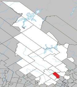 Location within Matawinie RCM | |
 Sainte-Béatrix Location in central Quebec | |
| Coordinates: 46°12′N 73°37′W / 46.200°N 73.617°WCoordinates: 46°12′N 73°37′W / 46.200°N 73.617°W[1] | |
| Country |
|
| Province |
|
| Region | Lanaudière |
| RCM | Matawinie |
| Constituted | May 11, 1864 |
| Government[2] | |
| • Mayor | Normand Montagne |
| • Federal riding | Joliette |
| • Prov. riding | Berthier |
| Area[2][3] | |
| • Total | 83.70 km2 (32.32 sq mi) |
| • Land | 84.00 km2 (32.43 sq mi) |
|
There is an apparent contradiction between two authoritative sources | |
| Population (2011)[3] | |
| • Total | 1,849 |
| • Density | 22.0/km2 (57/sq mi) |
| • Pop 2006-2011 |
|
| • Dwellings | 1,194 |
| Time zone | EST (UTC−5) |
| • Summer (DST) | EDT (UTC−4) |
| Postal code(s) | J0K 1Y0 |
| Area code(s) | 450 and 579 |
| Highways |
|
| Website |
www |
Sainte-Béatrix is a municipality in the Lanaudière region of Quebec, Canada, part of the Matawinie Regional County Municipality.
Demographics
Population
| Historical Census Data - Sainte-Béatrix, Quebec[4] | ||||||||||||||||||||||||||
|---|---|---|---|---|---|---|---|---|---|---|---|---|---|---|---|---|---|---|---|---|---|---|---|---|---|---|
|
|
| ||||||||||||||||||||||||
Private dwellings occupied by usual residents: 852 (total dwellings: 1194)
Language
Mother tongue:[5]
- English as first language: 0.9%
- French as first language: 96.8%
- English and French as first language: 0%
- Other as first language: 2.3%
See also
References
- ↑ Reference number 279287 of the Commission de toponymie du Québec (French)
- 1 2 Geographic code 62020 in the official Répertoire des municipalités (French)
- 1 2 Statistics Canada 2011 Census - Sainte-Béatrix census profile
- ↑ Statistics Canada: 1996, 2001, 2006, 2011 census
- ↑ Statistics Canada 2006 Census - Sainte-Béatrix community profile
 |
Saint-Côme | Sainte-Émélie-de-l'Énergie | | |
| |
Saint-Jean-de-Matha | |||
| ||||
| | ||||
| Saint-Alphonse-Rodriguez | Sainte-Marcelline-de-Kildare | Sainte-Mélanie |
| Municipalities | |
|---|---|
| Parishes | |
| Unorganized Territories | |
| |
This article is issued from Wikipedia - version of the 4/29/2015. The text is available under the Creative Commons Attribution/Share Alike but additional terms may apply for the media files.