Sainte-Marcelline-de-Kildare, Quebec
| Sainte-Marcelline-de-Kildare | |
|---|---|
| Municipality | |
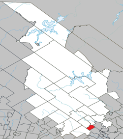 Location within Matawinie RCM. | |
 Sainte-Marcelline-de-Kildare Location in central Quebec. | |
| Coordinates: 46°07′N 73°36′W / 46.117°N 73.600°WCoordinates: 46°07′N 73°36′W / 46.117°N 73.600°W[1] | |
| Country |
|
| Province |
|
| Region | Lanaudière |
| RCM | Matawinie |
| Constituted | January 1, 1956 |
| Government[2] | |
| • Mayor | Gaétan Morin |
| • Federal riding | Joliette |
| • Prov. riding | Berthier |
| Area[2][3] | |
| • Total | 36.30 km2 (14.02 sq mi) |
| • Land | 34.68 km2 (13.39 sq mi) |
| Population (2011)[3] | |
| • Total | 1,567 |
| • Density | 45.2/km2 (117/sq mi) |
| • Pop 2006-2011 |
|
| • Dwellings | 947 |
| Time zone | EST (UTC−5) |
| • Summer (DST) | EDT (UTC−4) |
| Postal code(s) | J0K 2Y0 |
| Area code(s) | 450 and 579 |
| Highways |
|
| Website |
www |
Sainte-Marcelline-de-Kildare is a municipality in the Lanaudière region of Quebec, Canada, part of the Matawinie Regional County Municipality.
Demographics
Population
| Historical Census Data - Sainte-Marcelline-de-Kildare, Quebec[4] | ||||||||||||||||||||||||||
|---|---|---|---|---|---|---|---|---|---|---|---|---|---|---|---|---|---|---|---|---|---|---|---|---|---|---|
|
|
| ||||||||||||||||||||||||
Private dwellings occupied by usual residents: 692 (total dwellings: 947)
Language
Mother tongue:[5]
- English as first language: 3.2%
- French as first language: 95.0%
- English and French as first language: 0.7%
- Other as first language: 1.1%
See also
References
- ↑ Reference number 56262 of the Commission de toponymie du Québec (French)
- 1 2 Geographic code 62030 in the official Répertoire des municipalités (French)
- 1 2 Statistics Canada 2011 Census - Sainte-Marcelline-de-Kildare census profile
- ↑ Statistics Canada: 1996, 2001, 2006, 2011 census
- ↑ Statistics Canada 2006 Census - Sainte-Marcelline-de-Kildare community profile
 |
Saint-Alphonse-Rodriguez | Sainte-Béatrix | Sainte-Mélanie | |
| |
||||
| ||||
| | ||||
| Rawdon | Saint-Ambroise-de-Kildare |
| Municipalities | |
|---|---|
| Parishes | |
| Unorganized Territories | |
| |
This article is issued from Wikipedia - version of the 3/1/2014. The text is available under the Creative Commons Attribution/Share Alike but additional terms may apply for the media files.