Sakuho, Nagano
| Sakuho 佐久穂町 | ||
|---|---|---|
| Town | ||
|
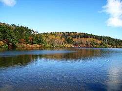
Shirakoma Pond | ||
| ||
 Location of Sakuho in Nagano | ||
 Sakuho Location in Japan | ||
| Coordinates: 36°10′N 138°29′E / 36.167°N 138.483°ECoordinates: 36°10′N 138°29′E / 36.167°N 138.483°E | ||
| Country | Japan | |
| Region |
Chūbu Kōshin'etsu | |
| Prefecture | Nagano | |
| District | Minamisaku | |
| Area | ||
| • Total | 188.15 km2 (72.65 sq mi) | |
| Population (October 1, 2015) | ||
| • Total | 11,192 | |
| • Density | 59.5/km2 (154/sq mi) | |
| Time zone | Japan Standard Time (UTC+9) | |
| City hall address |
569 Ōaza Takano-machi, Sakuho-machi, Minamisaku-gun, Nagano-ken 384-0697 | |
| Website |
town | |
Sakuho (佐久穂町 Sakuho-machi) is a town in Minamisaku District, Nagano Prefecture, Japan.
On March 20, 2005 the town of Saku, and the village of Yachiho, both from Minamisaku District, to form the new town of Sakuho.
As of October 1, 2015, the town had a population of 11,192 and a density of 59.5 per km². The total area is 188.15 km².
Geography
Located in eastern Nagano prefecture, it stretches from west to east. It is situated in the Saku Basin, between the high peaks Mount Arafune and Mount Tateshina. The Chikuma River flows through, and the mountainous parts of the town are located in the Yatsugatake-Chushin Kogen Quasi-National Park and the Myogi-Arafune-Saku Kogen Quasi-National Park.
- Mountains: Mount Morai
- Rivers: Chikuma River, Ōishi River, Nukui River
- Lakes: Futago Pond, Shirakoma Pond
Surrounding municipalities
External links
 Media related to Sakuho, Nagano at Wikimedia Commons
- Sakuho Official Site (Japanese)
This article is issued from Wikipedia - version of the 10/3/2016. The text is available under the Creative Commons Attribution/Share Alike but additional terms may apply for the media files.

