San Isidro, Cabuyao
This article is about the Barangay San Isidro in the City of Cabuyao. For the barangay in San Pablo City, see San Isidro, San Pablo City. For other uses, see San Isidro (disambiguation).
| Barangay San Isidro Barangay Putol-kamao City of Cabuyao | ||
|---|---|---|
| Urbanized Barangay | ||
| ||
| Nickname(s): Nayon ng San Isidro, Barrio San Isidro | ||
| Country |
| |
| Region | CALABARZON (Region IV-A) | |
| Province | Laguna | |
| City | Cabuyao | |
| Incorporated (settlement) | 1571 | |
| Government | ||
| • Type | Sangguniang Barangay, with Chairman as its head supported by seven (7) Barangay Councilors | |
| • Barangay Chairman | Emerson L. Devoma | |
| Area | ||
| • Urbanized Barangay | 3.14 km2 (1.21 sq mi) | |
| Population (May 2010) | ||
| • Urbanized Barangay | 18,145 | |
| • Density | 5,800/km2 (15,000/sq mi) | |
| • Urban | 18,145 | |
| Demonym(s) | San Isidreños | |
| Time zone | PST (UTC+8) | |
| • Summer (DST) | Manila (UTC) | |
| Zip Code | 4025 | |
| Area code(s) | 049 | |
| Languages | Tagalog and English | |
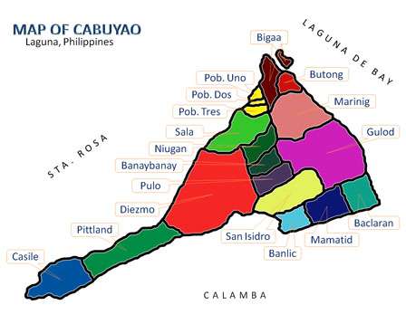
Barangay San Isidro (PSGC: 043404015) is one of the 18 urbanized[1] barangays, comprising the city of Cabuyao in the province of Laguna, Philippines. It is located around three kilometers from Cabuyao City proper, along the national highway. According to the 2010 Census,[2] it has a population of 18,145 (having increased from 15,495 in Census 2007[3]), making it the 5th largest barangay in Cabuyao by population.
The barangay got its name from its patron saint, San Isidro Labrador.
Demography
According to 2010 Census,[2] it has a population of 18,145 inhabitants, decreased from 15,495 in Census 2007.[3]
| No. | Barangay | Rank | Population (2007) | Population (2010) | Population Density (2010) | Annual Growth Rate (Average) |
|---|---|---|---|---|---|---|
| 1 | Baclaran | 9th | 12,683 | 12,192 | 6,985/km2 | |
| 2 | Banay-Banay | 4th | 17,419 | 21,934 | 7.073/km2 | |
| 3 | Banlic | 7th | 9,707 | 12,675 | 5,511/km2 | |
| 4 | Bigaa | 10th | 8,649 | 10,051 | 4,807/km2 | |
| 5 | Butong | 8th | 12,274 | 12,360 | 7,630/km2 | |
| 6 | Casile | 16th | 1,555 | 2,128 | 669/km2 | |
| 7 | Diezmo | 15th | 2,689 | 2,681 | 1,686/km2 | |
| 8 | Gulod | 11th | 10,127 | 9,417 | 2,304/km2 | |
| 9 | Mamatid | 1st | 37,166 | 50,213 | 19,313/km2 | |
| 10 | Marinig | 2nd | 25,619 | 37,169 | 9,494/km2 | |
| 11 | Niugan | 3rd | 21,993 | 26,807 | 7,615/km2 | |
| 12 | Pittland | 18th | 1,627 | 1,740 | 598/km2 | |
| 13 | Pulo | 6th | 13,193 | 15,124 | 5,041/km2 | |
| 14 | Sala | 12th | 7,491 | 8,275 | 5,353/km2 | |
| 15 | San Isidro | 5th | 15,495 | 18,145 | 5,767/km2 | |
| 16 | Barangay I Poblacion | 14th | 2,589 | 2,839 | 12,334/km2 | |
| 17 | Barangay II Poblacion | 17th | 1,947 | 1,840 | 7,886/km2 | |
| 18 | Barangay III Poblacion | 13th | 3,153 | 2,846 | 12,034/km2 | |
| | TOTAL | 6th | 205,376 | 248,436 | 5,700/km2 | |
Barangay Officials (2013-2016)
Barangay Captain: Emerson L. Devoma
Sangguniang Barangay Members:
- Dante "Kalag" M. Emergo
- John Christopher "JC" S. Canceran
- Antonio "Tony" S. Canceran
- Roderick "Boda" L. Cruz
- Joel L. Bautista
- Nelson L. Ramos
- Fernando "Dindo" E. Leoparte
See also
References
- ↑ Philippine Standard Geographic Code
- 1 2 "Final Results - 2010 Census of Population". census.gov.ph. Retrieved 2012-06-16.
- 1 2 2007 Census table for Laguna - National Statistics Office
External links
 |
Brgy. Diezmo, Cabuyao | Brgy. Pulo, Cabuyao | Brgy. Gulod, Cabuyao | |
| Brgy. Diezmo, Cabuyao | |
Brgy. Gulod, Cabuyao | ||
| ||||
| | ||||
| Brgy. Mapagong, Calamba City | Brgy. Banlic, Cabuyao | Brgy. Mamatid, Cabuyao |
| Geography |
|  | |||||
|---|---|---|---|---|---|---|---|
| City | |||||||
| Officials | |||||||
| History |
| ||||||
| Barangays | |||||||
| Notable people | |||||||
| |||||||
Coordinates: 14°16′42″N 121°7′29″E / 14.27833°N 121.12472°E
This article is issued from Wikipedia - version of the 9/13/2016. The text is available under the Creative Commons Attribution/Share Alike but additional terms may apply for the media files.