Pan-Philippine Highway
| |
|---|---|
| Maharlika Highway | |
 | |
| Route information | |
| Length: | 3,517 km (2,185 mi) |
| Component highways: |
|
| Major junctions | |
| North end: | Laoag City, Ilocos Norte |
| South end: | Zamboanga City |
| Highway system | |
| Highways in the Philippines | |
_sign.svg.png)
_sign.svg.png)
_sign.svg.png)
_sign.svg.png)
_sign.svg.png)
_sign.svg.png)
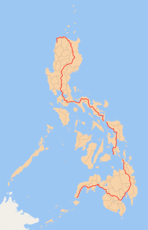
The Pan-Philippine Highway, also known as the Maharlika ("Nobility/freeman") Highway (![]() ) is a 3,517 km (2,185 mi) network of roads, bridges, and ferry services that connect the islands of Luzon, Samar, Leyte, and Mindanao in the Philippines, serving as the country's principal transport backbone.
) is a 3,517 km (2,185 mi) network of roads, bridges, and ferry services that connect the islands of Luzon, Samar, Leyte, and Mindanao in the Philippines, serving as the country's principal transport backbone.
The northern terminus of the highway is in Laoag, Ilocos Norte, and the southern terminus is in Zamboanga City.
Development
The highway was proposed in 1965, and built under President Ferdinand Marcos's governance. Government planners believed that the motorway and other connected roads would stimulate agricultural production by reducing transport costs, encourage social and economic development outside existing major urban centres such as Manila, and expand industrial production for domestic and overseas markets. Construction was supported by loans and grants from foreign aid institutions, including the World Bank.
The highway was rehabilitated and improved in 1997 with assistance from the Japanese government, and dubbed the Philippine-Japan Friendship Highway. In 1998, the Department of Tourism designated 35 sections of the highway as "Scenic Highways", with developed amenities for travellers and tourists.
The future segment of Pan-Philippine Highway within Metro Manila is the Skyway Stage 3 from Balintawak, Quezon City to Buendia, Makati City including the existing portion of Skyway Stage 1 from Buendia to Magallanes. It will also serves an alternate route for the motorists avoiding EDSA from North Luzon Expressway to South Luzon Expressway and vice versa.
Route

.JPG)
Main Route:
- Gen. Segundo Avenue, Laoag
- Bacarra - Tuguegarao
- Cagayan Valley Road: Tuguegarao - Ilagan - Santiago - Bayombong - Muñoz - Cabanatuan - Gapan - San Miguel - Baliuag
- Doña Remedios Trinidad Road: Baliuag - Pulilan - Guiguinto - Santa Rita (Guiguinto)
- NLEX: Santa Rita (Guiguinto) - Balintawak (Quezon City)(still unsigned as part of AH26)
- EDSA (Eastern Route): Balintawak (Quezon City) - Magallanes (Makati)
- SLEX: Magallanes (Makati) - Turbina (Calamba)(partially signed as AH26).
- Daang Maharlika/Manila South Road: Turbina (Calamba) - Santo Tomas - Alaminos - San Pablo - Tiaong - Lucena - Daet - Naga - Legazpi - Sorsogon City - Matnog
- Ferry from Matnog to Allen
- Allen - Catbalogan - Tacloban - Liloan
- Ferry from Liloan to Surigao City
- Surigao City - Butuan - Bayugan - Tagum - Davao City - Digos - General Santos - Koronadal - Tacurong - Sultan Kudarat - Pagadian - Ipil - Zamboanga City
Alternative Route
- C-4 Road, Radial Road 10, Roxas Boulevard, EDSA (Western Route): Balintawak (Quezon City) - Monumento (Caloocan) - Navotas - Ermita (Manila) - Pasay - Magallanes (Makati)
Asian Highway Network
The Pan-Philippine Highway is designated as ![]() in the Asian Highway Network, a cooperative project which seeks to improve highway systems and standards across the continent. It is currently the only highway in the system that is isolated from every other highway; island-based sections of the Asian Highway Network in Japan (
in the Asian Highway Network, a cooperative project which seeks to improve highway systems and standards across the continent. It is currently the only highway in the system that is isolated from every other highway; island-based sections of the Asian Highway Network in Japan (![]() ), Sri Lanka (AH43) and Indonesia (
), Sri Lanka (AH43) and Indonesia (![]() ) are all linked to the mainland sections by ferries to South Korea (
) are all linked to the mainland sections by ferries to South Korea (![]() ), India (Dhanushkodi), and Singapore, respectively.
), India (Dhanushkodi), and Singapore, respectively.
Major junctions
Luzon
- Manila North Road (Laoag)
- Cagayan Valley Road (Lal-lo)
- Santiago–Tuguegarao Road/Cagayan–Apayao Road (Tuguegarao)
- Santiago–Tuguegarao Road (Santiago)
- Cordon–Aurora Road (Cordon)
- Nueva Vizcaya–Ifugao Road (Bagabag)
- Baguio–Nueva Vizcaya Road (Aritao)
- Rizal–San Jose Road (San Jose)
- Pangasinan–Nueva Ecija Road (Santo Domingo)
- Nueva Ecija–Aurora Road (Cabanatuan)
- Tarlac–Santa Rosa Road (Santa Rosa)
- Jose Abad Santos Avenue (Gapan–Olongapo Road) (Gapan)
- North Luzon Expressway (Guiguinto)
- EDSA (Balintawak, Quezon City)
- Quezon Avenue (Diliman, Quezon City)
- Aurora Boulevard (Cubao, Quezon City)
- Ortigas Avenue (Ugong Norte, Quezon City)
- South Luzon Expressway (Makati)
- Alabang–Zapote Road (Muntinlupa)
- National Road/Manila South Road (Muntinlupa)
- Muntinlupa–Cavite Expressway to Daang Hari (Muntinlupa)
- Governor's Drive (Carmona)
- Santa Rosa–Tagaytay Road (Santa Rosa)
- Maharlika Highway/Manila South Road (Calamba)
- STAR Tollway (Santo Tomas)
- President Jose P. Laurel Highway (Santo Tomas)
- Batangas–Quezon Road (Tiaong)
- Lucena–Tayabas–Mauban Road (Lucena)
- Andaya Highway (Tagkawayan)
- Rolando Andaya Highway (Sipocot)
- Magsaysay and Panganiban Avenues (Naga)
- Almeda Highway (Naga)
See also
- Transportation in the Philippines
- Department of Public Works and Highways (Philippines)
- Asian Highway Network
- Philippine Nautical Highway System
References
- http://www.bookrags.com/history/worldhistory/pan-philippine-highway-ema-04/ (404: Page Not Found)
- http://manilarat.blogspot.com/2005/11/philippine-tourism-highway.html (Sorry, the page you were looking for in this blog does not exist.)
- http://www.philippineembassy-usa.org/about/economy.htm (Not Found. The requested URL was not found on this server.)
- http://www.rappler.com/newsbreak/iq/74846-ah26-road-sign
- http://www.dpwh.gov.ph/pdf/issuances/DO/09/DO_015_S2009.pdf (describes AH26 as MOSTLY segments of the Daang Maharlika)
External links
| Wikimedia Commons has media related to Pan-Philippine Highway. |
| Across the whole continent |  | |
|---|---|---|
| Southeast Asia | ||
| East Asia, Northeast Asia and Southeast Asia | ||
| South Asia | ||
| North Asia, Central Asia and Southwest Asia | ||