San Juan–Caguas–Guaynabo metropolitan area
- This article is about the "San Juan–Caguas–Guaynabo metropolitan area" comprising forty-one municipalities. The "San Juan metropolitan area" includes the immediate surrounding municipalities of Bayamón, Carolina, Cataño, Guaynabo, and Trujillo Alto.[1]
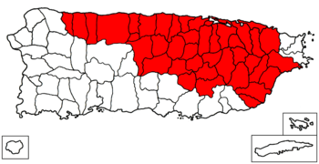
The San Juan-Caguas-Guaynabo Metropolitan Statistical Area[2] is a United States Census Bureau defined Metropolitan Statistical Area (MSA) in northeastern Puerto Rico. A July 1, 2009 Census Bureau estimate placed the population at 2,617,089, a 4.31% increase over the 2000 census figure of 2,509,007.[3]
The San Juan-Caguas-Guaynabo is the largest metropolitan area (by population) in Puerto Rico, covering approximately half of the island. Its principal cities are San Juan, Caguas and Guaynabo.[2]
Municipalities
A total of forty-one municipalities (Spanish: municipios) are included as part of the San Juan-Caguas-Guaynabo Metropolitan Statistical Area.[2][4] The total area for the MSA is 1,902.45 square miles. They are:
Combined Statistical Area

The San Juan-Caguas-Fajardo Combined Statistical Area (CSA) includes two metropolitan areas, one micropolitan area, and forty-five municipalities. A July 1, 2009 Census Bureau estimate placed the population at 2,732,036, a 4.16% increase over the 2000 census figure of 2,622,876. The San Juan-Caguas-Fajardo Combined Statistical Area comprises 68.9% of Puerto Rico's total population.[5]
Components
- Metropolitan Statistical Areas (MSAs)
- Fajardo (3 Municipalities)
- San Juan-Caguas-Guaynabo (41 Municipalities)
- Micropolitan Statistical Areas (USAs)
- Utuado Micropolitan Statistical Area (1 Municipality)
San Juan metropolitan area

The San Juan metropolitan area, (in spanish; área metropolitana de San Juan, abbreviated AMSJ), also referred to as the San Juan Metro Area is the area surrounding the City of San Juan which includes San Juan and its conurbation of the municipalities of Bayamón, Carolina, Cataño, Guaynabo and Trujillo Alto, and in some cases it is also includes Toa Baja, this occurs in all possible directions (South, West and East, the North is bounded by the Atlantic Ocean), without constituting as a whole an administrative unit but are tied together economically. After the municipality of San Juan, together they are also the most populous municipalities in the commonwealth of Puerto Rico.[6]
As per the 2015 United States Census Bureau estimates, the San Juan metropolitan area remains, by a significant margin, the most populous urban agglomeration in Puerto Rico with 1.25 million residents.
Municipalities San Juan Metro Area
Five (5) completely urbanized and integrated municipalities (townships) surrounding the city of San Juan, make up the "San Juan Metro Area":
See also
References
- ↑ www.upr.edu Office of the Dean of Graduate Studies and Research - Metropolitan area. Retrieved 2015-11-09.
- 1 2 3 www.whitehouse.gov Office of Management and Budget I The White House - Puerto Rico Metropolitan Statistical Area - Code 41980 - Revised Delineations of Metropolitan Statistical Areas as of 2013 Census Bureau. Retrieved 2015-11-09.
- ↑ "Table 3. Annual Estimates of the Population of Metropolitan and Micropolitan Statistical Areas in Puerto Rico: April 1, 2000 to July 1, 2009 (CBSA-EST2009-03)" (CSV). 2009 Population Estimates. United States Census Bureau, Population Division. 2010-03-23. Retrieved 2010-03-31.
- ↑ "Update of Statistical Area Definitions and Guidance on Their Uses (OMB Bulletin 08 - 01)" (CSV). 2007 Population Estimates. United States Census Bureau, Population Division. 2007-11-20. Retrieved 2008-11-10.
- ↑ "Table 4. Annual Estimates of the Population of Combined Statistical Areas in Puerto Rico: April 1, 2000 to July 1, 2009 (CBSA-EST2009-04)" (CSV). 2009 Population Estimates. United States Census Bureau, Population Division. 2010-03-23. Retrieved 2010-03-31.
- ↑ www.uprrp.edu.com Census Geography of Puerto Rico. Retrieved 2016-11-01