San Pablo, Colorado
| San Pablo, Colorado | |
|---|---|
| Unincorporated community | |
  Location in Costilla County and the state of Colorado | |
| Coordinates: 37°08′50″N 105°23′41″W / 37.14722°N 105.39472°WCoordinates: 37°08′50″N 105°23′41″W / 37.14722°N 105.39472°W | |
| Country |
|
| State |
|
| County | Costilla County[1] |
| Elevation[1] | 8,094 ft (2,467 m) |
| Time zone | MST (UTC-7) |
| • Summer (DST) | MDT (UTC-6) |
| ZIP code[2] | 81153 |
| Area code(s) | (719) |
| GNIS feature ID | 0193028 |
San Pablo is an unincorporated community and a U.S. Post Office located in Costilla County, Colorado, United States. The San Pablo Post Office has the ZIP Code 81153.[2]
Geography
San Pablo is located at 37°08′50″N 105°23′41″W / 37.14722°N 105.39472°W (37.147182,-105.394764).
Historic Buildings and Areas
- Catholic Church
- School
See also
References
- 1 2 "US Board on Geographic Names". United States Geological Survey. 2007-10-25. Retrieved 2008-01-31.
- 1 2 "ZIP Code Lookup" (JavaScript/HTML). United States Postal Service. January 3, 2007. Retrieved January 3, 2007.
Municipalities and communities of Costilla County, Colorado, United States | ||
|---|---|---|
| Towns | 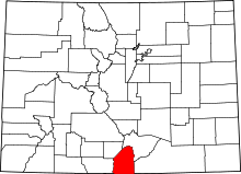 | |
| CDPs | ||
| Unincorporated communities | ||
This article is issued from Wikipedia - version of the 7/31/2016. The text is available under the Creative Commons Attribution/Share Alike but additional terms may apply for the media files.