Sandy Point, Maine
| Sandy Point, Maine | |
|---|---|
| Village | |
 Sandy Point | |
| Coordinates: 44°30′53″N 68°48′46″W / 44.51472°N 68.81278°WCoordinates: 44°30′53″N 68°48′46″W / 44.51472°N 68.81278°W | |
| Country | United States |
| State | Maine |
| County | Waldo |
| Elevation | 89 ft (27 m) |
| Time zone | Eastern (EST) (UTC-5) |
| • Summer (DST) | EDT (UTC-4) |
| ZIP code | 04972 |
| Area code(s) | 207 |
| GNIS feature ID | 574886[1] |
Sandy Point is an unincorporated village in the town of Stockton Springs, Waldo County, Maine, United States. The community is located along U.S. Route 1 on the west bank of the Penobscot River estuary, 4.1 miles (6.6 km) south of Bucksport. Sandy Point has a post office with ZIP code 04972, which opened on January 1, 1795.[2][3]
References
- ↑ "Sandy Point". Geographic Names Information System. United States Geological Survey.
- ↑ United States Postal Service. "USPS - Look Up a ZIP Code". Retrieved July 26, 2015.
- ↑ "Postmaster Finder - Post Offices by ZIP Code". United States Postal Service. Retrieved July 26, 2015.
Municipalities and communities of Waldo County, Maine, United States | ||
|---|---|---|
| City | 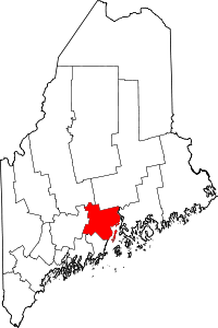 | |
| Towns | ||
| CDPs | ||
| Other villages | ||
This article is issued from Wikipedia - version of the 7/26/2015. The text is available under the Creative Commons Attribution/Share Alike but additional terms may apply for the media files.