Sankt Veit in der Südsteiermark
| Sankt Veit in der Südsteiermark | |
|---|---|
 Sankt Veit in der Südsteiermark Location within Austria | |
| Coordinates: 46°44′52″N 15°37′36″E / 46.74778°N 15.62667°ECoordinates: 46°44′52″N 15°37′36″E / 46.74778°N 15.62667°E | |
| Country | Austria |
| State | Styria |
| District | Murtal |
| Government | |
| • Mayor | Manfred Tatzl (ÖVP) |
| Area | |
| • Total | 68.67 km2 (26.51 sq mi) |
| Elevation | 260 m (850 ft) |
| Population (1 January 2016)[1] | |
| • Total | 4,069 |
| • Density | 59/km2 (150/sq mi) |
| Time zone | CET (UTC+1) |
| • Summer (DST) | CEST (UTC+2) |
| Postal codes | 8423, 8421, 8422, 8435, 8481 |
| Area code | 03453 |
| Website | www.st-veit-suedsteiermark.gv.at |

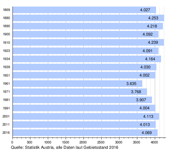
Sankt Veit in der Südsteiermark is a municipality since 2015 in the Leibnitz District of Styria, Austria. The population was 4,069 residents (as of 2016-01-01).
The municipality, Sankt Veit in der Südsteiermark, was created as part of the Styria municipal structural reform,[2] at the end of 2014, by merging the former towns Sankt Veit am Vogau and Sankt Nikolai ob Draßling, both in the political district Leibnitz, plus the town Weinburg am Saßbach in the political Südoststeiermark District.[3]
The borders of the Südoststeiermark District and Leibnitz District were shifted, so that the new municipality would lie completely within Leibnitz District.[4]
The former municipality Weinburg am Saßbach was until the end of 2012 in Radkersburg District and had the Kfz-code "RA“. From the middle of 2013 until the end of 2014, the code had abbreviation "SO"; in 2015 it was set as "LB".
Geography
Municipality arrangement
The municipality territory includes the following 11 Katastralgemeinden and 16 sections (populations as of 1 January 2015[5]):
| Katastralgemeinden | Ortschaften |
|---|---|
|
|
Neighboring municipalities
The municipality is bordered by seven neighboring towns, four were in Südoststeiermark District (SO).
| Schwarzautal | Mettersdorf am Saßbach (SO) and Sankt Peter am Ottersbach (SO) | ||
| Gabersdorf | |
Mureck (SO) | |
| |||
| | |||
| Straß in Steiermark | Murfeld (SO) |

Demographics

Politics
Mayor
Manfred Tatzl (ÖVP) was elected mayor of the newly formed municipality on 20 April 2015, in the inaugural meeting of the Municipal Council.[6] Tatzl was already, at the end of 2014, the mayor of the former municipality of St. Veit am Vogau and led from January 1, 2015, the transactions of the merged municipality as government commissioner.
Josef Pratter, the nearly 25-year mayor of St. Nikolai ob Draßling, was and the former mayor of the municipality of Weinburg am Saßbach, Susanne Lucchesi-Palli, came to the election.[7]
With the results from April 30, 2015, Manfred Tatzl traveled by his council mandate, because he wants to conduct the business of the merged municipality as a "People's Mayor". [7]
The town council also includes the first deputy mayor Gerhard Rohrer, the second Deputy Mayor Harald Schögler, the municipality treasurer Georg Pock and board member Rudolf Reinprecht.[6][8]
Municipality council
The town council has 21 members. After the 2015 election, the council had the following results:[8]
The prior elections brought the following results:
| Party | 2015 | 2010 | ||||||||||
|---|---|---|---|---|---|---|---|---|---|---|---|---|
| St. Veit in der Südsteiermark | St. Veit am Vogau | St. Nikolai ob Draßling | Weinburg am Saßbach | |||||||||
| Votes | % | Mandate | St. | % | M. | St. | % | M. | St. | % | M. | |
| ÖVP | 1458 | 56 | 12 | 767 | 58 | 9 | 588 | 74 | 11 | 497 | 69 | 10 |
| SPÖ | 736 | 28 | 6 | 518 | 39 | 6 | 107 | 13 | 2 | not running | ||
| FPÖ | 421 | 16 | 3 | 43 | 3 | 0 | 99 | 12 | 2 | not running | ||
| Einigkeit lohnt sich | not running | not running | not running | 228 | 31 | 5 | ||||||
| Counts | 3.444 | 1.530 | 927 | 912 | ||||||||
| Percentage | 77% | 87% | 87% | 83% | ||||||||
Coat of arms
- Wappen der Vorgängergemeinden
 Sankt Veit am Vogau
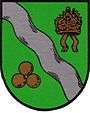 Sankt Nikolai ob Draßling
 Weinburg am Saßbach
All three predecessors had a town crest. Because of the merger, the crests lost their official validity on January 1, 2015. The authorization of the municipal coat of arms for the joined community took effect on 25 October 2016.[9]
Blazon (crest description):
- "Above the silvery shield-foot, over a black, silver-floated wave-beam green three grapes growing from common origin upward and two flat wine leaves, in blue a golden, richly arranged and of window and door fifteenfold black perforated with volute gable and two with Knauf and cross at golden towers; between these, a silver lion's head".
References
- ↑ Statistik Austria - Bevölkerung zu Jahresbeginn 2002-2016 nach Gemeinden (Gebietsstand 1.1.2016) for Sankt Veit in der Südsteiermark.
- ↑ Steiermärkische Gemeindestrukturreform
- ↑ Kundmachung der Steiermärkischen Landesregierung of 28 November 2013, about the union of market town Sankt Veit am Vogau and the municipality Sankt Nikolai ob Draßling, both in Leibnitz District, and the town Weinburg am Saßbach, in political district Südoststeiermark. Landesgesetzblatt für die Steiermark. 26 June 2014. Nr. 72, Jahrgang 2014. Template:ZDB-ID. p. 1.
- ↑ Verordnung der Steiermärkischen Landesregierung vom 10. Juli 2014, mit der die Steiermärkische Bezirkshauptmannschaftenverordnung geändert wird. Landesgesetzblatt für die Steiermark. 10 September 2014. Nr. 99 Jahrgang 2014. Template:ZDB-ID.
- ↑ Einwohner nach Ortschaften (Excel-Datei, 766 KB); accessed 29 July 2015
- 1 2 Gemeinde St. Veit in der Südsteiermark: Gemeindenachrichten Juni 2015 (pdf-Dokument, 367 KB), abgerufen am 15. Juni 2015
- ↑ Gemeinden St. Nikolai ob Draßling, Weinburg am Saßbach und St. Veit am Vogau: Gemeinsam Geschafft – Amtliche Informationszeitung der Gemeinden St. Nikolai ob Draßling, Weinburg am Saßbach und St. Veit am Vogau, 4. Ausgabe 4/2014 (pdf-Dokument, 4,02 MB), abgerufen am 15. Juni 2015
- 1 2 Gemeinde St. Veit in der Südsteiermark: Gemeindenachrichten März 2015 (pdf-Dokument, 500 KB), abgerufen am 15. Juni 2015
- ↑ 124. Verlautbarung der Steiermärkischen Landesregierung vom 13. Oktober 2016 über die Verleihung des Rechtes zur Führung eines Gemeindewappens an die Marktgemeinde Sankt Veit in der Südsteiermark (politischer Bezirk Leibnitz), abgerufen am 28. Oktober 2016
External links
| Wikimedia Commons has media related to Sankt Veit in der Südsteiermark. |
- "Municipal data for Sankt Veit in der Südsteiermark". Statistik Austria.
- Town of St. Veit in der Sudsteiermark: Official Homepage (in German)