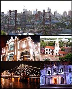
Santa Fe, Argentina
| Santa Fe | ||
|---|---|---|
| Santa Fe de la Vera Cruz City | ||
 | ||
| ||
 Santa Fe Location of Santa Fe in Argentina | ||
| Coordinates: 31°38′S 60°42′W / 31.633°S 60.700°WCoordinates: 31°38′S 60°42′W / 31.633°S 60.700°W | ||
| Country | Argentina | |
| Province | Santa Fe | |
| Department | La Capital | |
| Government | ||
| • Mayor | José Corral (UCR) | |
| Area | ||
| • Total | 748 km2 (289 sq mi) | |
| Elevation | 25 m (82 ft) | |
| Population | ||
| • Total | 653,073 | |
| • Density | 870/km2 (2,300/sq mi) | |
| Demonym(s) | santafesino | |
| Time zone | ART (UTC−3) | |
| CPA base | S3000 | |
| Dialing code | +54 342 | |
| Website | Official website | |
Santa Fe de la Vera Cruz (usually called just Santa Fe) is the capital city of the province of Santa Fe, Argentina. It is situated in north-eastern Argentina, near the junction of the Paraná and Salado rivers. It lies 15 kilometers from the Hernandarias Subfluvial Tunnel that connects it to the city of Paraná. The city is also connected by canal with the port of Colastiné on the Paraná River. Santa Fe has about 500.000 inhabitants as per the 2010 census [INDEC]. The metropolitan area has a population of 653.073, making it the eighth largest in Argentina.
Santa Fe is linked to Rosario (170 km (106 mi) to the south), the largest city in the province, by the Brigadier Estanislao López Highway and by National Route 11, which continues south towards Buenos Aires, and it is home to Sauce Viejo Airport with daily direct flights to Rosario and Aeroparque Jorge Newbery in Buenos Aires.
History
Santa Fe was founded by Captain Juan de Garay in the nearby site of Cayastá in 1573. The site is today a historical park containing the grave of Hernandarias, the first American-born governor in South America. The settlement was moved to the present site in 1653 due to the constant flooding of the Cayastá River. The city became the provincial capital in 1814, when the territory of the province of Santa Fe was separated from the province of Buenos Aires by the National Constituent Assembly, held in the city in 1853.
Santa Fe is the commercial and transportation center for a rich agricultural area that produces grain, vegetable oils, and meats. The city is the site of the National Technological University – Santa Fe Regional Faculty, Catholic University of Santa Fe (inaugurated in 1959), and the National University of the Littoral (first founded as the Provincial University in 1889, and which changed to its current name in 1919).
A suspension bridge was completed in 1924, though severe flooding partially destroyed it in 1983 (a second bridge, the Oroño, was opened in 1971). Santa Fe's location is still not immune to flooding, however. On April 29, 2003, the Salado, which empties into the Paraná near Santa Fe, rose almost 2 m (6.5 ft) in a few hours following heavy rainfall, and caused a catastrophic flood. No fewer than 100,000 people had to be evacuated, and large sections of the city remained under water more than a week later. That year, the suspension bridge was reopened, and in 2008, the city's historic grain silos were converted into the Los Silos Hotel and Casino, and San Martín Street was converted to pedestrian use.
The city's historical role in the Argentine Constitution led national lawmakers to choose it as the site of Constitutional Conventions in 1949, 1957, and 1994.
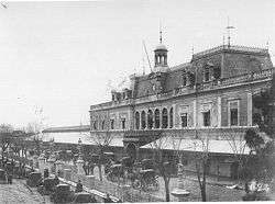 Santa Fe rail station (1905), today the long distance bus station
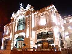
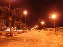
 Pedestrian San Martín Street
Climate
The city has a climate considered as "Humid subtropical" or "Cfa" by Köppen classification. Winters are generally mild, though minimum temperatures can fall below 0 °C (32.0 °F) on cold nights during the winter. Summers are generally hot and humid. During the most extreme heat waves, temperatures have exceeded 45 °C (113.0 °F). Temperatures have exceeded 35 °C (95.0 °F) in every season).[1]
Rainfall can be expected throughout the year though summer is usually the wettest season. Thunderstorms can be intense with frequent lightning, powerful downdraughts and intense precipitation. The lowest record temperature was −8.2 °C (17.2 °F) on July 11, 1988 while the highest recorded temperature was 45.6 °C (114.1 °F) on January 25, 1986.[1][2]
| Climate data for Santa Fe, SF (Sauce Viejo Airport) 1961–1990, extremes 1970–present | |||||||||||||
|---|---|---|---|---|---|---|---|---|---|---|---|---|---|
| Month | Jan | Feb | Mar | Apr | May | Jun | Jul | Aug | Sep | Oct | Nov | Dec | Year |
| Record high °C (°F) | 45.6 (114.1) |
40.9 (105.6) |
38.6 (101.5) |
35.1 (95.2) |
34.3 (93.7) |
29.9 (85.8) |
32.4 (90.3) |
38.6 (101.5) |
39.9 (103.8) |
41.0 (105.8) |
40.1 (104.2) |
41.5 (106.7) |
45.6 (114.1) |
| Average high °C (°F) | 32.1 (89.8) |
30.7 (87.3) |
28.1 (82.6) |
24.5 (76.1) |
21.6 (70.9) |
17.8 (64) |
17.8 (64) |
19.6 (67.3) |
21.8 (71.2) |
25.0 (77) |
27.9 (82.2) |
30.6 (87.1) |
24.8 (76.6) |
| Daily mean °C (°F) | 25.4 (77.7) |
24.3 (75.7) |
22.1 (71.8) |
18.4 (65.1) |
15.6 (60.1) |
11.9 (53.4) |
11.8 (53.2) |
13.1 (55.6) |
15.2 (59.4) |
18.6 (65.5) |
21.5 (70.7) |
24.1 (75.4) |
18.5 (65.3) |
| Average low °C (°F) | 19.5 (67.1) |
18.9 (66) |
17.3 (63.1) |
13.8 (56.8) |
10.7 (51.3) |
7.3 (45.1) |
7.3 (45.1) |
7.9 (46.2) |
9.8 (49.6) |
13.2 (55.8) |
15.9 (60.6) |
18.2 (64.8) |
13.3 (55.9) |
| Record low °C (°F) | 9.3 (48.7) |
8.2 (46.8) |
4.1 (39.4) |
0.2 (32.4) |
−5.0 (23) |
−6.0 (21.2) |
−8.2 (17.2) |
−5.0 (23) |
−2.5 (27.5) |
0.2 (32.4) |
4.9 (40.8) |
5.6 (42.1) |
−8.2 (17.2) |
| Average precipitation mm (inches) | 114 (4.49) |
113 (4.45) |
151 (5.94) |
90 (3.54) |
45 (1.77) |
28 (1.1) |
28 (1.1) |
35 (1.38) |
59 (2.32) |
99 (3.9) |
108 (4.25) |
101 (3.98) |
977 (38.46) |
| Average precipitation days (≥ 0.1 mm) | 8 | 7 | 9 | 7 | 5 | 4 | 5 | 5 | 6 | 8 | 8 | 8 | 80 |
| Average relative humidity (%) | 74 | 79 | 82 | 85 | 85 | 86 | 85 | 82 | 79 | 77 | 77 | 75 | 81 |
| Mean monthly sunshine hours | 269.7 | 240.1 | 210.8 | 180.0 | 167.4 | 135.0 | 148.8 | 179.8 | 171.0 | 217.0 | 240.0 | 241.8 | 2,401.4 |
| Percent possible sunshine | 63 | 64 | 55 | 53 | 50 | 44 | 46 | 54 | 47 | 55 | 58 | 54 | 54 |
| Source #1: NOAA,[3] Oficina de Riesgo Agropecuario (record highs and lows)[2] | |||||||||||||
| Source #2: Servicio Meteorológico Nacional (precipitation days 1961–1990, humidity 1981–1990),[1][4] UNLP (sun only)[5] | |||||||||||||
The city
Santa Fe has a lot of important commercial centres, busy cultural life, interesting options in sports and tourism, numerous artistic and musical events, and an exciting nightlife.
There is important infrastructure for tourism that has been developed: river side bars and nightclubs, chic restaurants, the improvement of the major highways and a subfluvial tunnel and, combine that with the beauty of the landscape and the various attractions that tourists enjoy make this a popular region to spend holidays. Hunting, fishing, excursions, walks by the river, practising water sports on the River Paraná (18 km away via Nº168 National Road), visiting the Space Observation Centre or the Zoo- Experimental Station of "La Esmeralda" Farm, make the tourist feel amazed and eager to know more about the region.
In a nutshell, Santa Fe offers a complete and varied shade of attractions that make one dive into history when visiting monuments, museums or find oneself in the beautiful parks, rivers and streams surrounded by wild flora and fauna.
Transport
Railway
Despite of having had four railway stations, nowadays the city Santa Fe is not served by rail transport. The Mitre Railway station is no longer used since 2007, when defunct company Trenes de Buenos Aires cancelled its services to Santa Fe. Likewise, the Santa Fe Belgrano (built in 1891 and named Cultural Heritage) and Guadalupe stations had been entered into disuse in 1993 when the railway privatisation in Argentina ceased all the long-distance services in the country.
In the 2010s, the local municipality remodelled both stations as Guadalupe would be terminus for a new urban train.[6][7] Nevertheless, the original project was not carried out. On the other hand, the Santa Fe Belgrano station was re-opened as a convention center.[8]
The fourth station (also the oldest of all) had been built by French company Province of Santa Fe Railway in 1885. It was demolished in 1962 and replaced by a bus station.[9]
Railway stations in the city of Santa Fe are:
| Name | Former company | Line | Status (passenger) |
|---|---|---|---|
| Sante Fe (Mitre) | BA & Rosario | Mitre | Closed (2007) 1 |
| Santa Fe (Belgrano) | Central Northern | Belgrano | Closed (1993) 2 |
| Guadalupe | Central Northern | Belgrano | Closed (1993) 3 |
| Central Station | Prov. Santa Fe | Belgrano | Demolished (1962) 4 |
Notes:
- 1 No longer active since TBA cancelled its services.
- 2 Granted in concession to the Municipality of Santa Fe that remodelled it completely. The station re-opened as a convention center.
- 3 Refurbished in 2011 by the Municipality to be terminus of an urban train.[7] Nevertheless, the project was not carried out.
- 4 Also known as "La Francesa", it was demolished in 1962 to build a bus station.
Sports
Santa Fe put itself on the international sports map as one of the host cities of the 1990 FIBA World Championship.[10] The games were played in the Estadio de la Facultad Regional Santa Fe.
Notable natives
- Actor Star System Carlos Thompson
- Actor and theater director Norman Briski
- Actor and Humorist Marcos Mundstock (Les Luthiers)
- Composer/Musician Ariel Ramírez
- Plastic artist Ricardo Supisiche
- Writer Liliana Bodoc
- Writer Osvaldo Bayer
- Journalist and writer Sergio Rubin
- Poet, writer and playwright Francisco Urondo
- Boxer Carlos Baldomir
- Boxer Julio César Vásquez
- Basketball player Carlos Delfino
- Basketball player Tayavek Gallizzi
- Volleyball player Luciano De Cecco
- Pole vaulter Germán Chiaraviglio
- Polo player Arturo Kenny
- Sprint Canoeist Rubén Rézola
- Swimmer Santiago Grassi
- Sport shooter Amelia Fournel
- Football players Enrique García
- Football players René Pontoni
- Football players Leopoldo Luque
- Football players Pedro Pablo Pasculli
- Football players Sebastián Battaglia
- Football players and manager Juan Antonio Pizzi
- Provincial caudillo and governor Estanislao López
- F1 driver and governor Carlos Reutemann
- Diplomat and director OPCW Rogelio Pfirter
See also
- Category:People from Santa Fe, Argentina
- Paraná River steamers
References
- 1 2 3 "Guía Climática para el Turismo (Climate Guide for Tourists)" (in Spanish). Retrieved January 23, 2008.
- 1 2 "Sauce Viejo, Santa Fe". Estadísticas meteorológicas decadiales (in Spanish). Oficina de Riesgo Agropecuario. Retrieved April 13, 2015.
- ↑ "Sauce Viejo AERO Climate Normals 1961–1990 (CLINO)". National Oceanic and Atmospheric Administration. Retrieved July 4, 2015.
- ↑ "Valores Medios de Temperature y Precipitación-Santa Fe: Sauce Viejo" (in Spanish). Servicio Meteorológico Nacional. Retrieved July 4, 2015.
- ↑ "Datos bioclimáticos de 173 localidades argentinas". Atlas Bioclimáticos (in Spanish). Universidad Nacional de La Plata. Retrieved June 15, 2015.
- ↑ "Acondicionan la Estación Guadalupe, en Santa Fe, con vistas al proyecto de tren urbano", El Litoral, 2010
- 1 2 "Puesta en valor de la Estación Guadalupe", El Santafesino, 18 Mar 2011
- ↑ "Estación Belgrano" on Government of Santa Fe website
- ↑ "Ferrocarril en Santa Fe"
- ↑ 1990 World Championship for Men, Archive.FIBA.com, Retrieved 18 March 2016.
External links
- Official website of Santa Fe Municipality (Spanish)
- Santa Fe, Argentina at DMOZ
 Santa Fe, Argentina travel guide from Wikivoyage