Santa Rita, Montana
| Santa Rita, Montana | |
|---|---|
| CDP | |
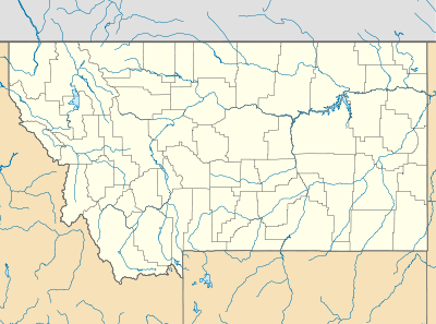 Santa Rita, Montana Location of Santa Rita, Montana | |
| Coordinates: 48°41′52″N 112°19′2″W / 48.69778°N 112.31722°WCoordinates: 48°41′52″N 112°19′2″W / 48.69778°N 112.31722°W | |
| Country | United States |
| State | Montana |
| County | Glacier |
| Area | |
| • Total | 3.20 sq mi (8.28 km2) |
| • Land | 3.20 sq mi (8.28 km2) |
| • Water | 0.00 sq mi (0.00 km2) |
| Elevation | 3,793 ft (1,156 m) |
| Population (2010) | |
| • Total | 113 |
| • Density | 35/sq mi (14/km2) |
| Time zone | Mountain (MST) (UTC-7) |
| • Summer (DST) | MDT (UTC-6) |
| Area code(s) | 406 |
| GNIS feature ID | 2583843[1] |
Santa Rita is a census-designated place (CDP) in Glacier County, Montana, United States. The population was 113 at the 2010 census.[2]
Climate
According to the Köppen Climate Classification system, Santa Rita has a semi-arid climate, abbreviated "BSk" on climate maps.[3]
References
Municipalities and communities of Glacier County, Montana, United States | ||
|---|---|---|
| City | 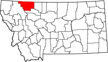 | |
| Town | ||
| CDPs | ||
| Unincorporated communities |
| |
| Indian reservation | ||
| Footnotes | ‡This populated place also has portions in an adjacent county or counties | |
This article is issued from Wikipedia - version of the 7/2/2015. The text is available under the Creative Commons Attribution/Share Alike but additional terms may apply for the media files.