Sar Pass Trek
| Sar Pass सार दर्रा | |
|---|---|
| Mountain Pass | |
 Sar Pass  Sar Pass | |
| Coordinates: 32°04′12″N 77°23′18″E / 32.07°N 77.388455°ECoordinates: 32°04′12″N 77°23′18″E / 32.07°N 77.388455°E | |
| Country | India |
| State | Himachal Pradesh |
| District | Kullu |
| Elevation | 4,220 m (13,850 ft) |
| Languages | |
| • Official | Hindi |
| • Regional | Kulvi |
The Sar Pass is in Parvati Valley of Kullu district of Himachal Pradesh, a state of India. A trek to Sar Pass is organised every year by various groups,Youth Hostels Association of India and many other groups. This is one of the most challenging and difficult treks.
Sar, in local dialect, means a lake. While trekking, across the path from Tila Lotni to Biskeri Ridge, one has to pass by a small, (normally) frozen lake (Sar) and hence the name Sar Pass Trek.
History
Conducted by Kailash Rath',[1] TripHippie,[2] ' & Youth Hostels of India YHAI with Grahan (7,700 ft) being the first camp after Kasol, followed by Padri (8,900 ft), Minh Thatch (10,700 ft), Nagaru (12,500 ft), Biskeri Thatch (11,000 ft), and Bhandak Thatch (8,000 ft). Only since 2007, this route has been changed. Camps were made on the ridge, which could be seen from naked eyes even starting from Grahan. It generally used to be covered in snow with frequent snowfalls even during May.
For the Last 8 years before 2011 the Trek to Sar Pass from the Kasol Valley Base Camp use to go through the Unchdhar, Sheela Village, Gauna Pani, Faul Pani,Zirmi, Tila Lotni - Sar Pass, Biskeri Bandhak Thatch Route, But the Old Trek Route from the Grahan Village restarted from 2011.
Grahan Village
The Village of Grahan is small village located deep inside the Parvati valley tributaries, It falls on route the Sar Pass trek from Kasol. As every village in the region has deity, Grahan’s deity is called ‘Yagya Maharishi’, who is strictly forbids the existence of alcohol in his village. Consumption of alcohol can end you in serious consequences, such as paying heavy fines, etc.
The people of the village originally come from two families and, it is mandatory that the marriage of a villager will happen only with a member of the other family and not his family or an outsider.
Itineraries

Kailash Rath[3]
- DAY 1: Receiving at Rumsu base camp.
- DAY 2: Jeep ride till Kasol and trek to Grahan village. Trek duration 4 –5 hours . Camping at Grahan.
- DAY 3: Trek to Min Thach. Duration 3–4 hours . Overnight stay at Min Thach camp site.
- DAY 4: Trek to Nagaru. Duration 4–6 hours. Overnight stay at Nagari.
- DAY 5:Trek to Biskeri Thach via Sar Pass. Duration 6–8 hours. Overnight stay in tents at Biskeri Thach.
- DAY 6: Trek to Barshaini. Duration : 4–5 hours. Jeep Ride to Rumsu base camp. Duration 2–3 hours. Overnight at Rumsu base camp.
- DAY 7: Departure from Rumsu after breakfast.
Yhai
- Day 1: Kasol Base Camp
- Day 2:Grahan Village
- Day 3: Padri
- Day 4: Mingtatch
- Day 5: Nagaru
- Day 6: Beskari
- Day 7: Bhandak Thatch
How To Reach
Air
The nearest airport Bhuntar Airport (IATA code KUU) is at Bhuntar town, situated on NH21 about 32.3 km (20.1 mi) south of Rumsu and 10 km (6.2 mi) south of Kullu town. The airport is also known as Kullu-Manali airport and has more than a kilometre long runway. Air India and some private airlines have regular flights to the airport. Recently Himalayan Bulls in collaboration with Deccan Charters have started flights on Kullu-Chandigarh-Kullu sector thrice a day http://himalayanbulls.com/ Daily flight service (except Tuesday) has been started by 15May 2013 at Bhunter airport by Air India from Delhi to Bhuntar and vice versa. Chandigarh Airport is the nearest international airport.
Road
Kasol is 30 km from Bhunter, and Bhunter can be reached from Delhi by national highway NH 1 up to Ambala and from there NH 22 to Chandigarh and from there by national highway NH21 that passes through Bilaspur, Sundernagar, Mandi and Kullu towns. The road distance from Chandigarh to Manali is 316 km (196 mi), and the total distance from Delhi to Manali is 566 km (352 mi). Buses (including Volvo and Mercedes Benz) on this route are available from all major bus terminals.
Rail
Kasol is not easily approachable by rail. The nearest broad gauge railheads are at Chandigarh (275 km (171 mi)), Pathankot (325 km (202 mi)) and Kalka (310 km (193 mi)). The nearest narrow gauge railhead is at Joginder Nagar (135 kilometres (84 mi)).
See Bilaspur-Mandi-Leh Railway for the proposed railway line through this area.
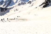
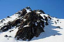
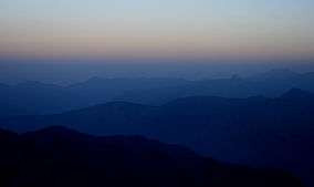
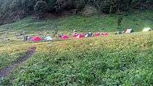
Gallery
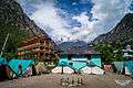 Kasol-Base Camp
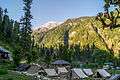 Grahan-Camp 2
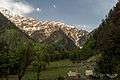 Padri-Camp 3
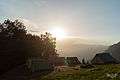 Minh Thatch-Camp 4
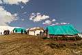 Nagaru-Camp 5
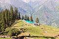 Biskeri-Camp 6
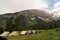 Bhandak Thatch-Camp 7
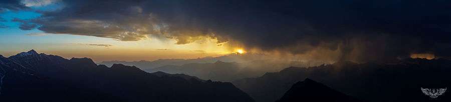
View from Nagaru Camp (12,500ft)
External links
- Base Camp at Kasol To Grahan Trek
- Birds of Sar Pass Trek & Saurkundi Pass Trek
- Butterflies of Sar Pass Trek & Saurkundi Pass Trek
- Landscapes of Sar Pass Trek
| Wikimedia Commons has media related to Sar Pass Trek. |