Savannah metropolitan area
| Savannah, Georgia Metropolitan Statistical Area | |
|---|---|
| Savannah–Hinesville–Statesboro Combined Statistical Area | |
|
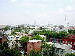
Downtown Savannah
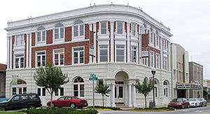 The Averitt Center for the Arts in Downtown Statesboro | |
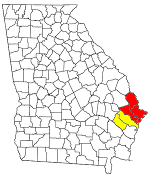 Map outlining the Savannah–Hinesville–Statesboro CSA | |
| Country |
|
| State |
|
| Largest city | Savannah |
| Area | |
| • Metro | 1,569 sq mi (4,060 km2) |
| • CSA | 3,265 sq mi (8,460 km2) |
| Population (2015) | |
| • Density | 238/sq mi (92/km2) |
| • Metro | 379,199(138th)[1] |
| • CSA | 532,048(86th) |
| • CSA density | 161/sq mi (62/km2) |
| Time zone | EST (UTC-5) |
| • Summer (DST) | EDT (UTC-4) |
| Area code(s) | 912 |

The Savannah metropolitan area is a metro area centered on the principal city of Savannah, Georgia. The official name given by the U.S. Office of Management and Budget (OMB) is the Savannah, Georgia Metropolitan Statistical Area, which is used for statistical purposes by the United States Census Bureau and other entities. The OMB defines this area as consisting of Bryan, Chatham, and Effingham counties in Georgia; its total population was estimated at 379,199 in 2015.[2] In the official 2010 census, the Savannah MSA had a population of 347,611, an 18.6 percent increase from the 2000 population of 293,000.[3] The Savannah MSA is the third most populous of fourteen Georgia MSAs (ranked after Atlanta and Augusta) as well as one of the fastest-growing metro areas in the state for the period 2000-2010 (exceeded only by Atlanta, Gainesville, Warner Robins and Brunswick).
Counties
| County | Population (2015) |
|---|---|
| Chatham County | 286,956 |
| Effingham County | 57,106 |
| Bryan County | 35,137 |
| Total: | 379,199 |
Communities
(Note: "census-designated places" are unincorporated)
Places with more than 140,000 inhabitants
- Savannah (principal city)
Places with 10,000 to 25,000 inhabitants
- Georgetown (census-designated place)
- Pooler
- Wilmington Island (census-designated place)
Places with 5,000 to 10,000 inhabitants
- Garden City
- Port Wentworth
- Richmond Hill
- Rincon
- Skidaway Island (census-designated place)
- Whitemarsh Island (census-designated place)
Places with 1,000 to 5,000 inhabitants
- Bloomingdale
- Guyton
- Isle of Hope (census-designated place)
- Montgomery (census-designated place)
- Pembroke
- Springfield
- Thunderbolt
- Tybee Island
Places with less than 1,000 inhabitants
Unincorporated places with less than 1,000 inhabitants
Demographics
| Historical population | |||
|---|---|---|---|
| Census | Pop. | %± | |
| 1960 | 204,669 | — | |
| 1970 | 207,938 | 1.6% | |
| 1980 | 239,196 | 15.0% | |
| 1990 | 258,060 | 7.9% | |
| 2000 | 293,000 | 13.5% | |
| 2010 | 347,611 | 18.6% | |
| Est. 2015 | 379,199 | 9.1% | |
| U.S. Decennial Census [4] "Georgia", Encyclopedia Americana (Scholastic Libr., 2004), vol. 12, 519. 1960 and 1970 figures are based on the Census Bureau's current three-county metro definition. Before 1980, the census definition of Savannah's metro area included only one county: Chatham (1960 pop. 188,299; 1970 pop. 187,767). | |||
As of the census[5] of 2000, there were 293,000 people, 111,105 households, and 76,405 families residing within the MSA. The racial makeup of the MSA was 61.24% White, 34.87% African American, 0.26% Native American, 1.49% Asian, 0.06% Pacific Islander, 0.82% from other races, and 1.26% from two or more races. Hispanic or Latino of any race were 2.18% of the population.
The median income for a household in the MSA was $44,201, and the median income for a family was $50,052. Males had a median income of $37,992 versus $24,777 for females. The per capita income for the MSA was $19,940.
Combined Statistical Area
The Savannah–Hinesville–Statesboro Combined Statistical Area (CSA) is made up of six counties in Georgia. The statistical area includes two metropolitan areas and one micropolitan area. The 2015 U.S. Census estimated population for this area was 532,048, up from 495,745 at the 2010 Census.[6]
CSA Components
Two MSAs form part of the Savannah–Hinesville–Statesboro CSA.
| MSA | Population (2015) |
|---|---|
| Savannah, Georgia Metropolitan Statistical Area | 379,199 |
| Hinesville-Fort Stewart Metropolitan Statistical Area | 80,198 |
| Subtotal: | 459,397 |
One μSA joined the Savannah–Hinesville–Statesboro CSA in 2012.
| μSA | County | Population (2015) |
|---|---|---|
| Statesboro, GA Micropolitan Statistical Area | Bulloch County | 72,651 |
| Subtotal: | 72,651 |
Total CSA population (2015): 532,048
See also
References
- ↑ "Table 1. Annual Estimates of the Population of Metropolitan and Micropolitan Statistical Areas: April 1, 2010 to July 1, 2012" (CSV). 2012 Population Estimates. United States Census Bureau, Population Division. March 2013. Retrieved 2013-06-05.
- ↑
- ↑ http://proximityone.com/metros0010.htm
- ↑ Data Access and Dissemination Systems (DADS). "American FactFinder - Results". census.gov.
- ↑ "American FactFinder". United States Census Bureau. Retrieved 2008-01-31.
- ↑ http://www.census.gov/popest/data/ametro/tables/2012/CBSA-EST2012-02.csv
Template:Georgia