Liberty County, Georgia
| Liberty County, Georgia | |
|---|---|
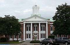 Liberty County Courthouse in Hinesville | |
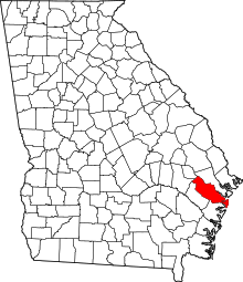 Location in the U.S. state of Georgia | |
 Georgia's location in the U.S. | |
| Founded | February 5, 1777 |
| Seat | Hinesville |
| Largest city | Hinesville |
| Area | |
| • Total | 603 sq mi (1,562 km2) |
| • Land | 490 sq mi (1,269 km2) |
| • Water | 113 sq mi (293 km2), 18.7% |
| Population | |
| • (2010) | 63,453 |
| • Density | 130/sq mi (50/km²) |
| Congressional district | 1st |
| Time zone | Eastern: UTC-5/-4 |
| Website |
www |
Liberty County is a county located in the U.S. state of Georgia. As of the 2010 census, the population was 63,453.[1] The county seat is Hinesville.[2]
Liberty County is part of the Hinesville, Georgia Metropolitan Statistical Area, which is also included in the Savannah-Hinesville-Statesboro, Georgia Combined Statistical Area.
History
Liberty county was established in 1777. It is named for the popular American ideal of liberty.[3] Sunbury was first designated the county seat in 1784. In 1797, the seat was transferred to Riceboro and in 1837 it was transferred again to Hinesville.[4]
Geography
According to the U.S. Census Bureau, the county has a total area of 603 square miles (1,560 km2), of which 490 square miles (1,300 km2) is land and 113 square miles (290 km2) (18.7%) is water.[5]
The eastern and southern portion of Liberty County is located in the Ogeechee Coastal sub-basin of the Ogeechee River basin. The northern and western portion of the county is located in the Canoochee River sub-basin of the Ogeechee River basin.[6]
Major highways
-
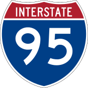 Interstate 95
 -
 U.S. Route 17
 -
 U.S. Route 84
 -
 State Route 25
 -
 State Route 38
 -
 State Route 38 Connector
 -
 State Route 119
 -
 State Route 144
 -
 State Route 196
 -
 State Route 405 (unsigned designation for I-95)
Adjacent counties
- Chatham County - northeast
- Bryan County - north
- McIntosh County - south
- Long County - west
- Evans County - northwest
- Tattnall County - northwest
Demographics
| Historical population | |||
|---|---|---|---|
| Census | Pop. | %± | |
| 1790 | 5,355 | — | |
| 1800 | 5,313 | −0.8% | |
| 1810 | 6,228 | 17.2% | |
| 1820 | 6,695 | 7.5% | |
| 1830 | 7,233 | 8.0% | |
| 1840 | 7,241 | 0.1% | |
| 1850 | 7,926 | 9.5% | |
| 1860 | 8,367 | 5.6% | |
| 1870 | 7,688 | −8.1% | |
| 1880 | 10,649 | 38.5% | |
| 1890 | 12,887 | 21.0% | |
| 1900 | 13,093 | 1.6% | |
| 1910 | 12,924 | −1.3% | |
| 1920 | 12,707 | −1.7% | |
| 1930 | 8,153 | −35.8% | |
| 1940 | 8,595 | 5.4% | |
| 1950 | 8,444 | −1.8% | |
| 1960 | 14,487 | 71.6% | |
| 1970 | 17,569 | 21.3% | |
| 1980 | 37,583 | 113.9% | |
| 1990 | 52,745 | 40.3% | |
| 2000 | 61,610 | 16.8% | |
| 2010 | 63,453 | 3.0% | |
| Est. 2015 | 62,467 | [7] | −1.6% |
| U.S. Decennial Census[8] 1790-1960[9] 1900-1990[10] 1990-2000[11] 2010-2013[1] | |||
2000 census
As of the census[12] of 2000, there were 61,610 people, 19,383 households, and 15,138 families residing in the county. The population density was 119 people per square mile (46/km²). There were 21,977 housing units at an average density of 42 per square mile (16/km²). The racial makeup of the county was 46.64% White, 42.84% Black or African American, 0.52% Native American, 1.76% Asian, 0.43% Pacific Islander, 4.43% from other races, and 3.37% from two or more races. 8.15% of the population were Hispanic or Latino of any race.
According to 2005 Census Estimates Liberty County had a population that was 44.5% African-American, 44.4% Non-Hispanic white, 7.2% Latino, 3.1% non-Hispanics who reported multiple races, 1.9% Asian and 0.5% of both Native Americans and Pacific Islanders.
There were 19,383 households out of which 50.50% had children under the age of 18 living with them, 59.60% were married couples living together, 14.80% had a female householder with no husband present, and 21.90% were non-families. 16.60% of all households were made up of individuals and 3.20% had someone living alone who was 65 years of age or older. The average household size was 2.93 and the average family size was 3.29.
In the county the population was spread out with 32.00% under the age of 18, 17.90% from 18 to 24, 33.90% from 25 to 44, 12.20% from 45 to 64, and 3.90% who were 65 years of age or older. The median age was 25 years. For every 100 females there were 111.30 males. For every 100 females age 18 and over, there were 115.10 males.
The median income for a household in the county was $33,477, and the median income for a family was $35,031. Males had a median income of $25,305 versus $20,765 for females. The per capita income for the county was $13,855. About 13.50% of families and 15.00% of the population were below the poverty line, including 19.20% of those under age 18 and 19.90% of those age 65 or over.
2010 census
As of the 2010 United States Census, there were 63,453 people, 22,155 households, and 16,566 families residing in the county.[13] The population density was 129.5 inhabitants per square mile (50.0/km2). There were 26,731 housing units at an average density of 54.6 per square mile (21.1/km2).[14] The racial makeup of the county was 47.1% white, 42.2% black or African American, 2.0% Asian, 0.6% Pacific islander, 0.6% American Indian, 2.9% from other races, and 4.7% from two or more races. Those of Hispanic or Latino origin made up 9.7% of the population.[13] In terms of ancestry, 8.8% were German, 6.9% were Irish, and 6.0% were American.[15]
Of the 22,155 households, 45.9% had children under the age of 18 living with them, 49.0% were married couples living together, 21.5% had a female householder with no husband present, 25.2% were non-families, and 20.7% of all households were made up of individuals. The average household size was 2.75 and the average family size was 3.18. The median age was 27.9 years.[13]
The median income for a household in the county was $42,674 and the median income for a family was $46,818. Males had a median income of $35,881 versus $31,159 for females. The per capita income for the county was $18,662. About 15.0% of families and 17.8% of the population were below the poverty line, including 26.2% of those under age 18 and 13.4% of those age 65 or over.[16]
Communities
In the media
The 2014 award-winning Independent film, A Promise, was filmed in Liberty County.[17][18]
See also
References
- 1 2 "State & County QuickFacts". United States Census Bureau. Retrieved June 23, 2014.
- ↑ "Find a County". National Association of Counties. Archived from the original on May 31, 2011. Retrieved 2011-06-07.
- ↑ Gannett, Henry (1905). The Origin of Certain Place Names in the United States. U.S. Government Printing Office. p. 186.
- ↑ Hellmann, Paul T. (May 13, 2013). Historical Gazetteer of the United States. Routledge. p. 233. Retrieved 30 November 2013.
- ↑ "US Gazetteer files: 2010, 2000, and 1990". United States Census Bureau. 2011-02-12. Retrieved 2011-04-23.
- ↑ "Georgia Soil and Water Conservation Commission Interactive Mapping Experience". Georgia Soil and Water Conservation Commission. Retrieved 2015-11-22.
- ↑ "County Totals Dataset: Population, Population Change and Estimated Components of Population Change: April 1, 2010 to July 1, 2015". Retrieved July 2, 2016.
- ↑ "U.S. Decennial Census". United States Census Bureau. Archived from the original on May 11, 2015. Retrieved June 23, 2014.
- ↑ "Historical Census Browser". University of Virginia Library. Retrieved June 23, 2014.
- ↑ "Population of Counties by Decennial Census: 1900 to 1990". United States Census Bureau. Retrieved June 23, 2014.
- ↑ "Census 2000 PHC-T-4. Ranking Tables for Counties: 1990 and 2000" (PDF). United States Census Bureau. Retrieved June 23, 2014.
- ↑ "American FactFinder". United States Census Bureau. Archived from the original on September 11, 2013. Retrieved 2011-05-14.
- 1 2 3 "DP-1 Profile of General Population and Housing Characteristics: 2010 Demographic Profile Data". United States Census Bureau. Retrieved 2015-12-30.
- ↑ "Population, Housing Units, Area, and Density: 2010 - County". United States Census Bureau. Retrieved 2015-12-30.
- ↑ "DP02 SELECTED SOCIAL CHARACTERISTICS IN THE UNITED STATES – 2006-2010 American Community Survey 5-Year Estimates". United States Census Bureau. Retrieved 2015-12-30.
- ↑ "DP03 SELECTED ECONOMIC CHARACTERISTICS – 2006-2010 American Community Survey 5-Year Estimates". United States Census Bureau. Retrieved 2015-12-30.
- ↑ "Film company sets premieres". www.bryancountynews.com. Retrieved 2016-03-26.
- ↑ "Georgia hears about local film industry". coastalcourier.com. Retrieved 2016-03-26.
 |
Evans County and Tattnall County | Bryan County | | |
| Long County | |
Atlantic Ocean | ||
| ||||
| | ||||
| McIntosh County |
Municipalities and communities of Liberty County, Georgia, United States | ||
|---|---|---|
| Cities | | |
| CDP | ||
| Unincorporated community | ||
Template:Georgia
Coordinates: 31°48′N 81°28′W / 31.80°N 81.46°W