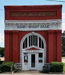
Shady Dale, Georgia
| Shady Dale, Georgia | |
|---|---|
| Town | |
 Location in Jasper County and the state of Georgia | |
| Coordinates: 33°23′58″N 83°35′24″W / 33.39944°N 83.59000°WCoordinates: 33°23′58″N 83°35′24″W / 33.39944°N 83.59000°W | |
| Country | United States |
| State | Georgia |
| County | Jasper |
| Area | |
| • Total | 0.8 sq mi (2.2 km2) |
| • Land | 0.8 sq mi (2.2 km2) |
| • Water | 0 sq mi (0 km2) |
| Elevation | 623 ft (190 m) |
| Population (2000) | |
| • Total | 242 |
| • Density | 302.5/sq mi (110/km2) |
| Time zone | Eastern (EST) (UTC-5) |
| • Summer (DST) | EDT (UTC-4) |
| ZIP code | 31085 |
| Area code(s) | 706 |
| FIPS code | 13-69784[1] |
| GNIS feature ID | 0329643[2] |
Shady Dale is a town in Jasper County, Georgia, United States. The population was 242 at the 2000 census.
History
Shady Dale was founded ca. 1880 on the site of a former Creek Indian settlement.[3]
Geography
Shady Dale is located at 33°23′58″N 83°35′24″W / 33.39944°N 83.59000°W (33.399562, -83.589937).[4]
According to the United States Census Bureau, the town has a total area of 0.8 square miles (2.1 km2), all of it land. It is home to the Silver Bullet Hunting club.
Demographics
| Historical population | |||
|---|---|---|---|
| Census | Pop. | %± | |
| 1890 | 152 | — | |
| 1900 | 300 | 97.4% | |
| 1910 | 344 | 14.7% | |
| 1920 | 294 | −14.5% | |
| 1930 | 243 | −17.3% | |
| 1940 | 159 | −34.6% | |
| 1950 | 253 | 59.1% | |
| 1960 | 201 | −20.6% | |
| 1970 | 190 | −5.5% | |
| 1980 | 155 | −18.4% | |
| 1990 | 180 | 16.1% | |
| 2000 | 242 | 34.4% | |
| 2010 | 249 | 2.9% | |
| Est. 2015 | 240 | [5] | −3.6% |
As of the census[1] of 2000, there were 242 people, 88 households, and 60 families residing in the town. The population density was 290.2 people per square mile (112.6/km²). There were 89 housing units at an average density of 106.7 per square mile (41.4/km²). The racial makeup of the town was 65.29% White, 28.10% African American, 6.61% from other races. Hispanic or Latino of any race were 6.61% of the population.
There were 88 households out of which 29.5% had children under the age of 18 living with them, 56.8% were married couples living together, 10.2% had a female householder with no husband present, and 30.7% were non-families. 28.4% of all households were made up of individuals and 12.5% had someone living alone who was 65 years of age or older. The average household size was 2.75 and the average family size was 3.41.
In the town the population was spread out with 27.7% under the age of 18, 7.9% from 18 to 24, 26.9% from 25 to 44, 25.2% from 45 to 64, and 12.4% who were 65 years of age or older. The median age was 35 years. For every 100 females there were 101.7 males. For every 100 females age 18 and over, there were 88.2 males.
The median income for a household in the town was $35,469, and the median income for a family was $36,042. Males had a median income of $31,000 versus $21,607 for females. The per capita income for the town was $10,791. About 10.5% of families and 14.6% of the population were below the poverty line, including 14.3% of those under the age of eighteen and 19.2% of those sixty five or over.
Arts and culture
The town is well known for an annual professional rodeo the first weekend in June each year since 1983. Sanctioned by the I.P.R.A./S.R.A., this rodeo draws champion cowboys and cowgirls from all over the United States. The entire town comes to life with a rodeo parade, wagon train ride and community festival. This successful event is produced by Walton No. 200 and Jasper No. 50 Masonic Lodges of Jasper County with proceeds benefiting several Masonic charities.
References
- 1 2 "American FactFinder". United States Census Bureau. Retrieved 2008-01-31.
- ↑ "US Board on Geographic Names". United States Geological Survey. 2007-10-25. Retrieved 2008-01-31.
- ↑ Wilson, J. S. (Apr 8, 2010). "The History of Shady Dale". The Monticello News. Retrieved 26 June 2014.
- ↑ "US Gazetteer files: 2010, 2000, and 1990". United States Census Bureau. 2011-02-12. Retrieved 2011-04-23.
- ↑ "Annual Estimates of the Resident Population for Incorporated Places: April 1, 2010 to July 1, 2015". Retrieved July 2, 2016.
- ↑ "Census of Population and Housing". Census.gov. Retrieved June 4, 2015.
External links
- Providence Baptist Church historical marker
Municipalities and communities of Jasper County, Georgia, United States | ||
|---|---|---|
| City | 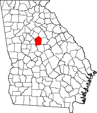 | |
| Town | ||
| Unincorporated community | ||