Shawnee, Colorado
| Shawnee, Colorado | |
|---|---|
| Unincorporated community | |
|
Entering Shawnee from the east | |
 Location in Park County and the state of Colorado | |
| Coordinates: 39°25′12″N 105°33′06″W / 39.42000°N 105.55167°WCoordinates: 39°25′12″N 105°33′06″W / 39.42000°N 105.55167°W | |
| Country |
|
| State |
|
| County | Park County[1] |
| Elevation[1] | 8,120 ft (2,475 m) |
| Time zone | MST (UTC-7) |
| • Summer (DST) | MDT (UTC-6) |
| ZIP code[2] | 80475 |
| GNIS feature ID | 0183232 |
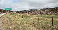
Shawnee is an unincorporated community and a U.S. Post Office located in northern Park County, Colorado, United States. Shawnee is situated in the Platte Canyon, along the North Fork South Platte River, west of Bailey on U.S. Highway 285.
The Shawnee Post Office has the ZIP Code 80475.[2]
Shawnee consists largely of a general store and post office, and well as surrounding houses, on the hillside south of the highway overlooking the river valley.
History
A post office called Shawnee has been in operation since 1900.[3] The community takes its name from nearby Shawnee Peak.[4]
Geography
Shawnee is located at 39°25′12″N 105°33′06″W / 39.42000°N 105.55167°W (39.420017,-105.551662).
References
- 1 2 "US Board on Geographic Names". United States Geological Survey. 2007-10-25. Retrieved 2008-01-31.
- 1 2 "ZIP Code Lookup" (JavaScript/HTML). United States Postal Service. January 3, 2007. Retrieved January 3, 2007.
- ↑ "Post offices". Jim Forte Postal History. Retrieved 9 July 2016.
- ↑ Dawson, John Frank. Place names in Colorado: why 700 communities were so named, 150 of Spanish or Indian origin. Denver, CO: The J. Frank Dawson Publishing Co. p. 46.
Municipalities and communities of Park County, Colorado, United States | ||
|---|---|---|
| Towns | 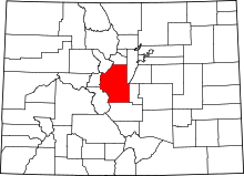 | |
| CDP | ||
| Unincorporated communities | ||
| Ghost towns | ||
This article is issued from Wikipedia - version of the 7/10/2016. The text is available under the Creative Commons Attribution/Share Alike but additional terms may apply for the media files.