Sherman, Wyoming
| Sherman, Wyoming | |
|---|---|
| Ghost town | |
 Sherman, Wyoming | |
| Coordinates: 41°07′52″N 105°23′53″W / 41.13111°N 105.39806°WCoordinates: 41°07′52″N 105°23′53″W / 41.13111°N 105.39806°W | |
| Country | United States |
| State | Wyoming |
| County | Albany |
| Elevation | 8,035 ft (2,449 m) |
| Time zone | Mountain (MST) (UTC-7) |
| • Summer (DST) | MDT (UTC-6) |
| Area code(s) | 307 |
| GNIS feature ID | 1594258[1] |
Sherman is a Ghost town in Albany County, Wyoming, United States. Sherman is 19 miles (31 km) southeast of Laramie in the Laramie Mountains. It is named for William Tecumseh Sherman. The town was located at the summit of the original grade of the First Transcontinental Railroad. Although the railroad has been regraded and relocated through this portion of Wyoming, the name Sherman, or Sherman Summit or Sherman Hill Summit has been applied to the nearby summits of the modern transportation arteries in the Laramie Mountains.
Ghost Town
The town of Sherman was named for William Tecumseh Sherman, purportedly at his own request.[2] It was located about 7.5 miles (12.1 km) south-southeast of the modern Sherman Summit and was the highest point on the original alignment of the First Transcontinental Railroad of the Union Pacific Railroad, at an elevation of 8,247 ft (2,514 m). Prior to being named Sherman, Union Pacific construction crews had called the area Lone Tree Pass and Evans Pass. The original name honored James Evans, who surveyed the area searching for a shorter route through Wyoming than the earlier trails which crossed at South Pass.[3] Because the tracks were later relocated a few miles south, the original town of Sherman no longer exists, but this is still the location of the Ames Monument, erected by the railroad to mark its original high point.[4]
Nearby Summits
Interstate 80
Sherman Summit or Sherman Hill Summit, elevation 8,640 ft (2,630 m),[5] is a mountain pass about 7.5 miles (12.1 km) north-northwest of the ghost town of Sherman at 41°14′11″N 105°26′12″W / 41.23635°N 105.43655°W. While not a particularly rugged mountain crossing, it holds special significance as the highest point along the entire length of transcontinental Interstate 80.[6]
Lincoln Highway
Just southwest of present-day Sherman Summit at 41°13′59″N 105°26′29″W / 41.23308°N 105.44127°W , at an elevation of about 8,820 ft (2,690 m),[5] is the highest point on the original transcontinental Lincoln Highway and its successor, U.S. 30. This location, where the pavement is still in place, is known simply as The Summit. A huge bronze bust of Abraham Lincoln once stood here; it has since been relocated to Sherman Summit.
Overland Route
As a result of the track relocation, the high point on the railroad, today known as the Overland Route, is now about 3.4 miles (5.5 km) southeast of the Ames Monument at 41°05′52″N 105°21′03″W / 41.09778°N 105.35083°W, at an elevation of 8,014 ft (2,443 m).[7] There is no town here, but the official railroad name for this location is, perhaps not surprisingly, Sherman. However, this point (like the Ames Monument) is not actually on the crest of the Laramie Mountains, which is now surmounted via the nearby Hermosa Tunnel at the slightly lower elevation of 7,960 ft (2,430 m).[8]
See also
- Buford, Wyoming - Town near Sherman Summit that claims to be the highest town on Interstate 80
References
- ↑ "Sherman". Geographic Names Information System. United States Geological Survey.
- ↑ Robert G. Athearn (1956). William T. Sherman and the Settlement of the West. p. 201.
- ↑ "The Union Pacific Reaches its Highest Elevation". Union Pacific Railroad. Retrieved January 20, 2016.
- ↑ "Sherman Mountains West, Wyoming, USGS 7.5 minute topographic map via Topoquest". USGS. Retrieved 2013-08-04.
- 1 2 "Sherman Mountains West, Wyoming, USGS 7.5 minute topographic map via Topoquest". USGS. Retrieved 2013-08-04.
- ↑ Official State Highway Map of Wyoming (Map). Wyoming Department of Transportation. 2014.
- ↑ "Buford, Wyoming, USGS 7.5 minute topographic map via Topoquest". USGS. Retrieved 2013-08-04.
- ↑ "Dale Creek, Wyoming, USGS 7.5 minute topographic map via TopoQuest". USGS. Retrieved 2013-12-23.
Municipalities and communities of Albany County, Wyoming, United States | ||
|---|---|---|
| City | 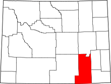 | |
| Town | ||
| CDPs | ||
| Unincorporated communities | ||