Laramie, Wyoming
| Laramie, Wyoming | |
|---|---|
| City | |
|
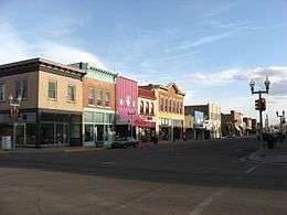
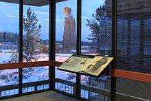
Downtown Laramie Historic District | |
| Motto: Gem City of the Plains | |
 Location in Albany County and the state of Wyoming. | |
| Coordinates: 41°19′N 105°35′W / 41.317°N 105.583°WCoordinates: 41°19′N 105°35′W / 41.317°N 105.583°W | |
| Country | United States |
| State | Wyoming |
| County | Albany |
| Government | |
| • Mayor | Dave Paulekas |
| Area[1] | |
| • City | 17.76 sq mi (46.00 km2) |
| • Land | 17.74 sq mi (45.95 km2) |
| • Water | 0.02 sq mi (0.05 km2) |
| Elevation | 7,165 ft (2,184 m) |
| Population (2010)[2] | |
| • City | 30,816 |
| • Estimate (2012[3]) | 31,681 |
| • Density | 1,700/sq mi (670/km2) |
| • Metro | 37,956 [4] |
| Time zone | MST (UTC-7) |
| • Summer (DST) | MDT (UTC-6) |
| ZIP Code | 82070-82073 |
| Area code | 307 |
| FIPS code | 56-45050[5] |
| GNIS feature ID | 1590526[6] |
| Website |
www |
Laramie /ˈlærəmi/ is a city and the county seat of Albany County, Wyoming, United States. The population was 30,816 at the 2010 census.[7] Located on the Laramie River in southeastern Wyoming, the city is west of Cheyenne, at the junction of Interstate 80 and U.S. Route 287.
Laramie was settled in the mid-19th century along the Union Pacific Railroad line, which crosses the Laramie River at Laramie. It is home to the University of Wyoming, Wyoming Technical Institute, and a branch of Laramie County Community College. Laramie Regional Airport serves Laramie. The ruins of Fort Sanders, an army fort predating Laramie, lie just south of the city along Route 287. Located in the Laramie Valley between the Snowy Range and the Laramie Range, the city draws outdoor enthusiasts with its abundance of outdoor activities.
In 2011, Laramie was named as one of the best cities in which to retire by Money Magazine, which cited its scenic location, low taxes, and educational opportunities.[8]
History
Laramie was named for Jacques LaRamie, a French or French-Canadian trapper who disappeared in the Laramie Mountains in the late 1810s and was never heard from again. He was one of the first Europeans to visit the area. European-American settlers named a river, mountain range, peak, US Army fort, county, and city for him. More Wyoming landmarks are named for him than for any other trapper but Jim Bridger.[9] Because the name was used so frequently, the town was called Laramie City for decades to distinguish it from other uses.
Laramie was founded in the mid-1860s as a tent city near the Overland Stage Line route, the Union Pacific portion of the first transcontinental railroad, and just north of Fort Sanders army post. The rails reached Laramie on May 4, 1868 when construction crews worked through town. A few passengers arrived on that same day.[10][11] The first regular passenger service began on May 10, 1868, by which time entrepreneurs were building more permanent structures. Laramie City (as it was known in early years) soon had stores, houses, a school, and churches.[12] Laramie's fame as the western terminal of the Union Pacific Railroad, acquired when the 268-mile (431 km) section from North Platte, Nebraska was opened in May ended in early August 1868 when a 93-mile (150 km) section of track was opened to Benton, 6 miles (9.7 km) east of present-day Sinclair, Wyoming.
Laramie suffered initially from lawlessness. Its first mayor, M. C. Brown, resigned his office on June 12, 1868 after six turbulent weeks, saying that the other officials elected alongside him on May 2 were guilty of "incapacity and laxity" in dealing with the city's problems.[13] This was due to the threat to the community from three half-brothers, early Old West gunman "Big" Steve Long, Con Moyer and Ace Moyer. Long was Laramie's first marshal, and with his brothers owned the saloon Bucket of Blood. The three began harassing settlers, forcing them to sign over the deeds to their property to them. Any who refused was killed, usually goaded into a gunfight by Long. By October 1868, Long had killed 13 men.
The first Albany County sheriff, rancher N. K. Boswell, organized a "Vigilance Committee" in response. On October 28, 1868, Boswell led the committee into the Bucket of Blood, overwhelmed the three brothers, and lynched them at an unfinished cabin down the street. Through a series of other lynchings and other forms of intimidation, the vigilantes reduced the "unruly element" and established a semblance of law and order.[14]
In 1869, Wyoming was organized as Wyoming Territory, the first legislature of which passed a bill granting equal political rights to women in the territory. In March 1870, five Laramie residents became the first women in the world to serve on a jury.[15] As Laramie was the first town in Wyoming to hold a municipal election, on September 6, 1870, a Laramie resident was the first woman in the United States to cast a legal vote in a general election.[12]
Early businesses included rolling mills, a railroad-tie treatment plant, a brick yard, a slaughterhouse, a brewery, a glass manufacturing plant, and a plaster mill, as well as the railroad yards. In 1886, a plant to produce electricity was built.[12] Several regional railroads were based in Laramie, including the Laramie, North Park and Pacific Railroad and Telegraph Company founded in 1880 and the Laramie, North Park and Western Railroad established in 1901.
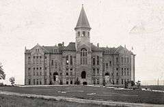
Governor Francis E. Warren signed a bill that established the University of Wyoming (UW) in 1886, the only public university in the state. Laramie was chosen as its site, and UW opened there in 1887. Under the terms of the Morrill Act, also known as the Land Grant College Act, in 1891 UW added an agricultural college and experiment station to gain benefits as a land grant college.[16]
Late 20th century to present
The city was covered by international media in 1998 after the murder of Matthew Shepard, a gay student at the University of Wyoming. His murder generated an international outcry.[17] It became the symbolic focus for a nationwide campaign against gay hate crimes. Federal hate crimes legislation was signed into law in 2009.[18] As of January 2011, Wyoming does not have a hate crimes law.[19] Shepard's murder was the subject of the award-winning play, later adapted as a movie, The Laramie Project.[20]
In 2004, Laramie became the first city in Wyoming to pass a law to prohibit smoking in enclosed workplaces, including bars, restaurants and private clubs. Opponents of the clean indoor air ordinance, funded in part by the R.J. Reynolds Tobacco Company, immediately petitioned to have the ordinance repealed. However, the voters upheld the ordinance in a citywide referendum which was conducted concurrently with the 2004 general election. The opponents challenged the validity of the election in court, claiming various irregularities. However, the judge ruled that the opponents had failed to meet their burden of showing significant problems with the election, and the ordinance, which had become effective in April 2005, remained in effect.[21] In August 2005, Laramie's City Council defeated an attempt to amend the ordinance to allow smoking in bars and private clubs.

Geography and climate
Laramie is located at 41°18′47″N 105°35′14″W / 41.31306°N 105.58722°W (41.312927, −105.587251).[22] According to the United States Census Bureau, the city has a total area of 17.76 square miles (46.00 km2), of which 17.74 square miles (45.95 km2) is land and 0.02 square miles (0.05 km2) is water.[1]
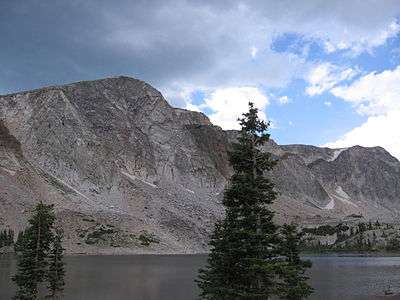
Laramie is on a high plain between two mountain ranges, the Snowy Range, about 30 miles (48 km) to the west, and the Laramie Range, 7 miles (11 km) to the east. The city's elevation above sea level is about 7,165 feet (2,184 m). The Laramie River runs through Laramie toward its confluence with the North Platte River east of the Laramie Range.
The city is about 50 miles (80 km) west of Cheyenne, Wyoming, and 130 miles (209 km) north of Denver, Colorado. Laramie lies along U.S. Route 30, Interstate 80, and U.S. Route 287, and it remains an important junction on the Union Pacific Railroad line.
Laramie's total precipitation averages about 11 inches (279 mm) a year, and the average number of rainy days per year is about 86. The city experiences a day that is 90 °F (32 °C) or warmer 2.2 times a year. The average temperature in December is 21.1 °F (−6.1 °C), and in July it is 64.0 °F (17.8 °C). Annual snowfall averages 48 inches (122 cm). Because of the high elevation, winters are long, and summers are short and relatively cool. The growing season is short, as the average window for freezing temperatures is September 14 through June 6, while for accumulating (≥0.1 inches or 0.25 centimetres) it is October 5 through May 12.
Laramie has a semi-arid climate (Köppen climate classification BSk) with long, cold, dry winters and short, warm, somewhat wetter summers.
| Climate data for Laramie, Wyoming (Laramie Regional Airport), 1981–2010 normals | |||||||||||||
|---|---|---|---|---|---|---|---|---|---|---|---|---|---|
| Month | Jan | Feb | Mar | Apr | May | Jun | Jul | Aug | Sep | Oct | Nov | Dec | Year |
| Record high °F (°C) | 59 (15) |
63 (17) |
71 (22) |
77 (25) |
87 (31) |
94 (34) |
94 (34) |
94 (34) |
90 (32) |
79 (26) |
70 (21) |
61 (16) |
94 (34) |
| Average high °F (°C) | 33.3 (0.7) |
35.2 (1.8) |
43.0 (6.1) |
51.1 (10.6) |
61.5 (16.4) |
72.5 (22.5) |
80.1 (26.7) |
77.9 (25.5) |
68.6 (20.3) |
55.7 (13.2) |
41.3 (5.2) |
32.2 (0.1) |
54.4 (12.4) |
| Average low °F (°C) | 10.1 (−12.2) |
11.9 (−11.2) |
18.7 (−7.4) |
24.6 (−4.1) |
33.7 (0.9) |
41.9 (5.5) |
48.0 (8.9) |
46.7 (8.2) |
37.9 (3.3) |
28.0 (−2.2) |
17.4 (−8.1) |
10.0 (−12.2) |
27.4 (−2.6) |
| Record low °F (°C) | −50 (−46) |
−39 (−39) |
−25 (−32) |
−14 (−26) |
5 (−15) |
22 (−6) |
30 (−1) |
28 (−2) |
−2 (−19) |
−18 (−28) |
−26 (−32) |
−34 (−37) |
−50 (−46) |
| Average precipitation inches (mm) | .27 (6.9) |
.34 (8.6) |
.59 (15) |
1.08 (27.4) |
1.69 (42.9) |
1.53 (38.9) |
1.43 (36.3) |
1.25 (31.8) |
1.11 (28.2) |
.80 (20.3) |
.58 (14.7) |
.37 (9.4) |
11.03 (280.2) |
| Average snowfall inches (cm) | 7.4 (18.8) |
8.3 (21.1) |
9.3 (23.6) |
9.5 (24.1) |
3.3 (8.4) |
.2 (0.5) |
0 (0) |
0 (0) |
.2 (0.5) |
2.4 (6.1) |
6.7 (17) |
6.5 (16.5) |
53.8 (136.6) |
| Average precipitation days (≥ 0.01 in) | 4.6 | 5.1 | 6.0 | 7.8 | 10.5 | 8.5 | 9.2 | 9.8 | 7.1 | 6.4 | 5.7 | 5.2 | 86.0 |
| Average snowy days (≥ 0.1 in) | 5.0 | 5.0 | 6.0 | 5.5 | 2.3 | .2 | 0 | 0 | .6 | 2.5 | 5.4 | 5.5 | 37.9 |
| Source: NOAA (extremes 1948–present)[23] | |||||||||||||
Demographics
| Historical population | |||
|---|---|---|---|
| Census | Pop. | %± | |
| 1870 | 828 | — | |
| 1880 | 2,696 | 225.6% | |
| 1890 | 6,388 | 136.9% | |
| 1900 | 8,207 | 28.5% | |
| 1910 | 8,237 | 0.4% | |
| 1920 | 6,301 | −23.5% | |
| 1930 | 8,609 | 36.6% | |
| 1940 | 10,627 | 23.4% | |
| 1950 | 15,581 | 46.6% | |
| 1960 | 17,520 | 12.4% | |
| 1970 | 23,143 | 32.1% | |
| 1980 | 24,410 | 5.5% | |
| 1990 | 26,687 | 9.3% | |
| 2000 | 27,204 | 1.9% | |
| 2010 | 30,816 | 13.3% | |
| Est. 2015 | 32,158 | [24] | 4.4% |
| source:[25][26][27] | |||
2010 census
As of the census[2] of 2010, there were 30,816 people, 13,394 households, and 5,843 families residing in the city. The population density was 1,737.1 inhabitants per square mile (670.7/km2). There were 14,307 housing units at an average density of 806.5 per square mile (311.4/km2). The racial makeup of the city was 89.5% White, 1.3% African American, 0.7% Native American, 3.2% Asian, 0.1% Pacific Islander, 2.5% from other races, and 2.8% from two or more races. Hispanic or Latino of any race were 9.2% of the population.
There were 13,394 households of which 20.4% had children under the age of 18 living with them, 33.0% were married couples living together, 6.9% had a female householder with no husband present, 3.7% had a male householder with no wife present, and 56.4% were non-families. 36.9% of all households were made up of individuals and 6.2% had someone living alone who was 65 years of age or older. The average household size was 2.14 and the average family size was 2.85.
The median age in the city was 25.4 years. 15.9% of residents were under the age of 18; 32.7% were between the ages of 18 and 24; 26.5% were from 25 to 44; 17.4% were from 45 to 64; and 7.5% were 65 years of age or older. The gender makeup of the city was 52.0% male and 48.0% female.
2000 census
As of the census[5] of 2000, there were 27,204 people, 11,336 households, and 5,611 families residing in the city. The population density was 2,442.5 people per square mile (942.9/km²). There were 11,994 housing units at an average density of 1,076.9 per square mile (415.7/km²). The racial makeup of the city was 90.81% White, 1.24% African American, 0.89% Native American, 1.92% Asian, 0.06% Pacific Islander, 2.89% from other races, and 2.19% from two or more races. Hispanic or Latino of any race were 7.94% of the population.
There were 11,336 households out of which 23.0% had children under the age of 18 living with them, 38.3% were married couples living together, 8.0% had a female householder with no husband present, and 50.5% were non-families. 33.2% of all households were made up of individuals and 6.4% had someone living alone who was 65 years of age or older. The average household size was 2.19 and the average family size was 2.83.
In the city the population was spread out with 17.5% under the age of 18, 31.8% from 18 to 24, 25.8% from 25 to 44, 16.8% from 45 to 64, and 8.1% who were 65 years of age or older. The median age was 25 years. For every 100 females there were 107.0 males. For every 100 females age 18 and over, there were 106.7 males.
The median income for a household in the city was $27,319, and the median income for a family was $43,395. Males had a median income of $30,888 versus $22,009 for females. The per capita income for the city was $16,036. About 11.1% of families and 22.6% of the population were below the poverty line, including 15.7% of those under age 18 and 8.3% of those age 65 or over.
Arts and culture
Annual cultural events
Laramie Jubilee Days started in 1940 to celebrate Wyoming Statehood Day on July 10. Since then, Jubilee Days has expanded to include several days around the Fourth of July. Events typically include food, live music, games, carnival rides, a street fair, a parade, a softball tournament, and rodeo events.[28]
Museums and concert halls
The Geological Museum at the University of Wyoming is open to the public and houses more than 50,000 catalogued mineral, rock, and fossil specimens, including a dinosaur exhibit.[29] The university's art museum offers gallery exhibits, lectures, workshops, classes, and public tours year-round.[30] The Fine Arts Concert Hall on campus presents frequent concerts and recitals during the school year.[31] Housed in the Ivinson Mansion near the center of town is the Laramie Plains Museum.[32] The Wyoming Children's Museum and Nature Center has interactive exhibits and pottery classes for children aged 3 and older.[33]
Libraries
The central library of the Albany County Library system, with a wide range of materials for adults and children, is near downtown Laramie; the system's branch libraries are in Centennial, 28 miles (45 km) west of Laramie and Rock River, 32 miles (51 km) northwest of Laramie.[34] William Robertson Coe Library, the main library of the University of Wyoming, has materials for general research in business, education, fine arts, science, humanities, and the social sciences as well as audio visual and government documents collections. The Brinkerhoff Geology Library specializes in geology, geophysics, physical geography, mining and petroleum geology, and geological engineering. Also at the university are the George W. Hooper Law Library, the Library Annex, a high-density storage facility located in the basement of the UW Science Complex, the Rocky Mountain Herbarium Library, a learning resources center with materials for teachers and children, and an archives, rare book, and manuscript repository known as the American Heritage Center.[35]
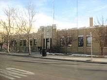
National Register sites
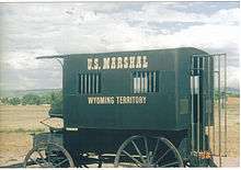
Twenty-one sites in Laramie, including the Wyoming Territorial Penitentiary, are included on the National Register of Historic Places (NRHP). The prison site includes buildings and other exhibits from a frontier community of the late 19th century. The other sites are the Downtown Laramie Historic District, the Ivinson Mansion and Grounds, Old Main on the University of Wyoming campus, the Barn at Oxford Horse Ranch, Bath Ranch, Bath Row, Charles E. Blair House, John D. Conley House, Cooper Mansion, East Side School, Fort Sanders Guardhouse, William Goodale House, Lehman-Tunnell Mansion, Lincoln School, Richardson's Overland Trail Ranch, St. Matthew's Cathedral Close, St. Paulus Kirche, Snow Train Rolling Stock, Union Pacific Athletic Club, and the Vee Bar Ranch Lodge.[36]
.jpg)
Two other Albany County sites near Laramie are on the NRHP. About 20 miles (32 km) east of the city is the Ames Monument, a large granite pyramid dedicated to brothers Oakes Ames, a Republican member of the United States House of Representatives from Massachusetts, and Oliver Ames, Jr., who were influential in building the Union Pacific portion of the First Transcontinental Railroad. Oakes Ames was also implicated in the Credit Mobilier scandal and censured by the U.S. House. The other site is Como Bluff, a long ridge extending east–west between Rock River and Medicine Bow. Geologic formations in the ridge contain fossils, including dinosaurs, from the Late Jurassic.[36]
Sports
College
The University of Wyoming Cowboys compete at the NCAA Division I level (FBS-Football Bowl Subdivision for football) as a member of the Mountain West Conference. UW offers 17 NCAA-sanctioned sports teams – nine women’s sports and eight men’s sports. Wyoming’s nine NCAA sports for women include basketball; cross country; golf; soccer; swimming and diving; tennis; indoor track & field; outdoor track and field; and volleyball. UW’s eight NCAA sports for men include basketball; cross country; football; golf; swimming and diving; indoor track and field; outdoor track and field; and wrestling.
Outdoor
Sports enthusiasts find much to do in and near Laramie, nestled at 7,165 feet (2,184 m) above sea level between the Laramie Range (Laramie Mountains) and the Snowy Range (Medicine Bow Mountains). Popular activities include skiing, snowmobiling, mountain biking, hunting, fishing, and hiking.

Rock climbing, hiking, and camping are among the attractions of Vedauwoo, an assemblage of weathered granite slabs, boulders, and cliffs covering 10 square miles (26 km2) in the Medicine Bow – Routt National Forest, about 16 miles (26 km) east of Laramie off Interstate 80.[37]
Volunteers from the Medicine Bow Nordic Association, in cooperation with the Forest Service, maintain groomed cross-country ski trails in a sector of the Laramie Range about 10 miles (16 km) east of the city.[38] To the west, Snowy Range cross-country trails run through the national forest west of Centennial, and other trails follow gentle terrain 32 miles (51 km) southwest of Laramie near Woods Landing. Miles of snowmobile trails wind through the forests, and many forest areas are open to travel by snowshoe.[39] The Snowy Range Ski Area, about 30 miles (48 km) west of Laramie off Wyoming Highway 130, offers downhill skiing and snowboarding on 27 trails ranging in difficulty from beginner to expert.[40]
Laramie is a center for mountain biking. Mountain bike trails meander through forests in the Laramie Range and the Snowy Range. The Medicine Bow Mountain Bike Patrol, part of the Laramie Bicycling Network, is a non-profit volunteer organization that works with the Forest Service to patrol and maintain biking trails east of Laramie. The Medicine Bow Rail–Trail is a mountain bike trail, 21 miles (34 km) long, built between 2005 and 2007 on the bed of an abandoned railroad southwest of Laramie. It starts near the town of Albany and Lake Owen and extends south to the town of Mountain Home near the Wyoming–Colorado border. The Laramie Enduro 111K, an endurance mountain bike race of 111 kilometres (69 mi) is held annually on Laramie Range trails.[41]
Other annual events include the Poker Run recreational ski race held in the Snowy Mountains each February, and the Tour De Laramie, a bicycle rally with stops at local pubs held in April. The Wyoming Marathon Races, a series of running and ultra-running events held in Medicine Bow National Forest, are held annually each Memorial Day weekend.
Trout fishing is another popular sport in and near Laramie. The Laramie River, which flows north into Wyoming from Colorado, is fished as are the smaller streams in both mountain ranges and the many small plains lakes in the Laramie Basin.[42]
Other outdoor activities popular near Laramie include camping, picnicking, rafting on the Laramie River and the North Platte River, viewing of wildlife such as mule deer, elk, moose, and pronghorn, and general sightseeing. For 27 miles (43 km) of its length as it crosses the Snowy Range, the Highway 130 corridor has been designated a National Forest Scenic Byway.[43]
Parks and recreation
Laramie has 14 city parks that, among them, include playgrounds, seasonal wading pools, jogging and biking paths, baseball and softball fields, a skateboard park, horseshoe pits, tennis courts, volleyball courts, a fitness circuit court, soccer fields, picnic tables, river fishing, and a seasonally stocked fishing pond.[44] Laramie residents also have access to the University of Wyoming's 18-hole golf course,[45] as well as a wide variety of university recreation sites including squash courts, handball courts, baseball diamonds, basketball courts, a climbing wall, and fields for football, soccer, and track.[46]
The Community Recreation Center has an outdoor swimming pool, an indoor pool, an eight-lane lap pool, water slides, a full-court gymnasium, cardio equipment, circuit weights, and an indoor playground, and it offers programs in adult fitness, youth volleyball, junior basketball, and aquatics.[47] The Community Ice Arena is open for ice skating, skating lessons, hockey, synchronized skating, adult co-ed broomball, and other ice-related activities from October through mid-March. A children's hockey club, a figure skating club, university hockey teams, and adult non-check hockey teams as well as the general public use the ice arena.[48]
Environmental problems
According to a 2012 report by the Wyoming Department of Environmental Quality (DEQ), a former industrial site for the production of aluminum, arsenic acid, strategic metals and cement now owned by L.C. Holdings, 2 miles (3.2 km) south of Laramie had arsenic concentrations in on-site water well samples 3,100-times higher than DEQ cleanup levels.[49] The site has been storing a 1,000-ton pile of contaminated flue dust from Bunker Hill Mine and Smelting Complex, an Idaho superfund site, under a tarp since the 1980s.[49] In 2011 L.C. Holdings entered the DEQ's "Voluntary Remediation Program".
Government and laws
Laramie has a council-manager form of government. The council, the city's legislative body, consists of nine members who serve overlapping four-year terms. The council members set policy, approve budgets, pass ordinances, appoint citizen volunteers to advisory boards, and oversee the city staff.[50] Two members of the council hold at-large seats, and seven are elected from city wards, one per ward. The council picks a mayor and vice-mayor once every two years at the first council meeting in January.[50] Laramie is the county seat of Albany County and houses county offices, courts,[51] and the county library.
In 2015, Laramie passed an LGBT anti-discrimination bill.[52] The ordinance bans discrimination against LGBT people in employment, housing and public accommodations such as bars and restaurants.[52]
Education
Albany County School District#1, headquartered in Laramie, governs 19 public schools in an area of 4,000 square miles (10,000 km2) including Laramie, Centennial, Rock River, and rural locations. A total of about 3,400 students attend these schools, the Laramie fraction of which includes seven elementary schools, two middle schools, Laramie High School, and Whiting High School.[53] Snowy Range Academy, a charter school, serves children in grades K–7,[54] and St. Laurence, a Catholic school, serves children in grades K–6.[55] The University of Wyoming also offers a Lab School (colloquially referred to as "Prep") for K–9 students.[56]
The main campus of the University of Wyoming is in Laramie. In 2009, about 13,400 students were enrolled there at the undergraduate, graduate, and professional levels.[57] The Laramie County Community College is also in Laramie. WyoTech also has a campus in Laramie, offering career training in the automotive, diesel, and collision-repair industries.[58]
Media
The Laramie Boomerang is Laramie's main newspaper. The Branding Iron is a student-run newspaper at the University of Wyoming. Wyoming Public Television station KCWC-DT, licensed to Central Wyoming College in Riverton, has a transmitter near Laramie known as KWYP-DT.[59]
Many radio stations broadcast from Laramie. Three are Wyoming Public Radio stations: KUWR, 91.9 FM; KUWY, 88.5 FM, classical, and KUWL, 90.1 FM, jazz.[60] The others are KOCA-LP, 93.5 FM, Spanish; KCGY, 95.1 FM, country; KIMX, 96.7 FM, top 40 (CHR); KRQU, 98.7 FM, classic rock; KARS, 102.9 FM, classic rock; KHAT, 1210 AM, sports; and KOWB, 1290 AM, news and talk.[61][62]
In popular culture
From 1958 to 1962, Laramie was the setting for ABC TV series Lawman, starring John Russell and Peter Brown, and from 1959 to 1963, Laramie was also the name of an NBC western television series, starring John Smith and Robert Fuller as ranch partners who operate a stagecoach station 12 miles (19 km) east of the city. Laramie in its early days is also featured in Season 5 of the AMC western television drama series, Hell On Wheels, set in California and in Laramie.[63]
Infrastructure and transportation
Major highways
 I-80 East-West Interstate running from California to New Jersey. Intersects US 287 in Laramie.
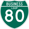 I-80 Bus. Alternate Business Route running from I-80 just east of Laramie, concurrent with Grand Avenue, through the city to North 3rd Street, US 287.
 US 30 (Lincoln Highway)
 US 287 (Yellowstone Highway)
 WYO 130 (Snowy Range Road)
 WYO 230 (Meg the Mumbler Road)
Airport
SkyWest Airlines (United) provides daily commercial flights between Laramie Regional Airport and Denver, Colorado.[64] The airport, 3 miles (5 km) west of the central business district, is operated and financed by the City of Laramie and Albany County. In addition to commercial flights, the airport serves private and corporate planes and atmospheric research aircraft from the University of Wyoming.[65]
Ground Transportation
Laramie has one taxi company, Snowy Range Taxi, LLC (formerly Here and There Shuttle, LLC), which has operated since 2011. The city is also served by Greyhound Lines, with service to and from Cheyenne and Fort Collins. Greenride of Northern Colorado provides service from Laramie to Fort Collins and Denver International Airport.
Utilities
The city's drinking water comes from the Big Laramie River, the largest single source, and wellfields in the Casper Aquifer, and it is treated in a modern plant.[66] The city's wastewater plant, which replaced an older plant, began operation in 1998.[67] The Solid Waste Division operates the city-owned landfill, about 1 mile (1.6 km) north of the city.[68] Laramie has 135 miles (217 km) of streets and 31 miles (50 km) of alleys.[69]
Notable people
Academics and writers who live or have lived in Laramie include poets Craig Arnold and H.L. (Harvey) Hix, archeologists George Frison and William Mulloy, historian Grace Raymond Hebard, and author Chip Rawlins. Attorneys with ties to Laramie include Thurman Arnold, Richard Honaker, Gerry Spence, and Tom Lubnau, who in 2013 became Speaker of the Wyoming House of Representatives.
Actors Jim Beaver and Wayde Preston are from Laramie as are Olympic athlete Jesseca Cross and professional basketball player Jaycee Carroll. Broadcaster Larry Birleffi covered University of Wyoming sports for many years. Sheridan H. Downey, born in Laramie, became a U.S. Senator from California.
Other notables with Laramie connections are the Wyoming Superintendent of Public Instruction Jillian Balow
- The aviation pioneer Raymond A. Johnson,[70] *Timothy Mellon, chairman and majority owner of Pan Am Systems
- Matthew Shepard, a murdered gay University of Wyoming student
- Pete Simpson, a university administrator
- Teenage Bottlerocket, a punk rock band.
- William L. Carlisle, one of America's last train robbers, lived in the town.
References
- 1 2 "US Gazetteer files 2010". United States Census Bureau. Retrieved 2012-12-14.
- 1 2 "American FactFinder". United States Census Bureau. Retrieved 2012-12-14.
- ↑ "Population Estimates". United States Census Bureau. Retrieved 2013-06-01.
- ↑ http://factfinder.census.gov/faces/tableservices/jsf/pages/productview.xhtml?pid=PEP_2015_PEPANNRES&prodType=table
- 1 2 "American FactFinder". United States Census Bureau. Retrieved 2008-01-31.
- ↑ "US Board on Geographic Names". United States Geological Survey. 2007-10-25. Retrieved 2008-01-31.
- ↑ "Profile of General Population and Housing Characteristics: 2010 Demographic Profile Data (DP-1): Laramie city, Wyoming". U.S. Census Bureau, American Factfinder. Retrieved June 10, 2012.
- ↑ http://laramielive.com/money-magazine-recognizes-laramie-as-a-great-place-to-retire/
- ↑ Parkin, Patsy, "Jacques LaRamie History", 2000. Retrieved on April 14, 2008.
- ↑ Frontier Index. 5 May 1868. Missing or empty
|title=(help) - ↑ Cheyenne Leader. 5 May 1868. Missing or empty
|title=(help) - 1 2 3 "Laramie History" Laramie Plains Museum. Retrieved on August 11, 2007.
- ↑ Frontier Index. 16 June 1868. Missing or empty
|title=(help) - ↑ "Chapter 3: Coming of Rails" Roberts, Phil (editor), University of Wyoming History Department, Readings in Wyoming History. Retrieved on August 11, 2007.
- ↑ "Chapter 4: Establishing the Territory and Granting Women Equal Rights Roberts, Phil (editor), University of Wyoming History Department, Readings in Wyoming History. Retrieved on August 11, 2007.
- ↑ "Fact Book: Historical Highlights" University of Wyoming. Retrieved on August 12, 2007.
- ↑ "Americans mourn gay hate-crime victim". BBC News. 1998-10-17.
- ↑ Matthew Shepard Hate Crimes Act passes Congress, finally
- ↑ US State Hate Crimes Legislation Summary
- ↑ Matthew Shepard and Laramie: A crime that lingers, New York Times. Retrieved on January 22, 2011.
- ↑ Laramie Smoking Ban Subject of Television Program Tuesday" University of Wyoming news release, October 16, 2006. Retrieved on August 10, 2007.
- ↑ "US Gazetteer files: 2010, 2000, and 1990". United States Census Bureau. 2011-02-12. Retrieved 2011-04-23.
- ↑ "NowData - NOAA Online Weather Data". National Oceanic and Atmospheric Administration. Retrieved 2013-07-01.
- ↑ "Annual Estimates of the Resident Population for Incorporated Places: April 1, 2010 to July 1, 2015". Retrieved July 2, 2016.
- ↑ "Historical Decennial Census Population for Wyoming Counties, Cities, and Towns". Wyoming Department of State / U.S. Census Bureau. Retrieved 2008-06-30.
- ↑ Moffatt, Riley. Population History of Western U.S. Cities & Towns, 1850-1990. Lanham: Scarecrow, 1996, 341.
- ↑ "Subcounty population estimates: Wyoming 2000-2007" (CSV). United States Census Bureau, Population Division. March 3, 2009. Retrieved May 8, 2009.
- ↑ "Laramie Jubilee Days". Laramie Jubilee Days. 2012. Retrieved January 13, 2013.
- ↑ "Geological Museum". University of Wyoming. Retrieved 2007-10-23.
- ↑ "Art Museum: General Information". University of Wyoming. Retrieved 2007-10-23.
- ↑ "Concerts, Events, Recitals". University of Wyoming. Retrieved 2007-10-27.
- ↑ "Historic Ivinson Mansion". The Laramie Plains Museum. Retrieved 2007-10-23.
- ↑ "Wyoming Children's Museum & Nature Center". Wyoming State Historical Society. Archived from the original on 2007-10-14. Retrieved 2007-10-23.
- ↑ "Albany County Public Library". Albany County Public Library. Retrieved 2007-10-24.
- ↑ "Libraries at UW". The University of Wyoming. Retrieved 2008-03-12.
- 1 2 "National Register of Historic Places: State listings: Wyoming: Albany County". National Park Service, U.S. Department of the Interior. Retrieved 2008-02-11.
- ↑ "Vedauwoo Campground". U.S. Department of Agriculture, Forest Service. Retrieved 2007-10-28.
- ↑ "Medicine Bow Nordic Association". Medicine Bow Nordic Association. Retrieved 2007-10-27.
- ↑ "Winter Activities". U.S. Department of Agriculture, Forest Service. Retrieved 2007-10-28.
- ↑ "The Mountain". Snowy Range Ski Area. Retrieved 2007-10-28.
- ↑ "Medicine Bow Mountain Bike Patrol". Cycle Wyoming. Retrieved 2007-10-28.
- ↑ Kristopherson, K. "Laramie River from Colorado into Wyoming". Wyoming Fishing Net. Archived from the original on 2007-07-02. Retrieved 2007-10-28.
- ↑ "Recreation". U.S. Department of Agriculture, Forest Service. Retrieved October 28, 2007.
- ↑ "City Parks". City of Laramie. Archived from the original on 2008-01-01. Retrieved 2007-10-27.
- ↑ "Glenn "Red" Jacoby Golf Course". University of Wyoming. Retrieved 2007-10-29.
- ↑ "Campus Recreation". University of Wyoming. Retrieved 2007-10-29.
- ↑ "Recreation Center". City of Laramie. Archived from the original on 2007-08-19. Retrieved 2007-10-27.
- ↑ "Laramie Community Ice Arena". City of Laramie. Archived from the original on 2007-08-19. Retrieved 2007-10-27.
- 1 2 CHILTON TIPPIN (April 12, 2014). "DEQ overseeing cleanup of site south of Laramie". Laramie Boomerang. Cheyenne Newspapers Inc. Retrieved 27 August 2014.
- 1 2 "City Council". City of Laramie. Retrieved January 13, 2013.
- ↑ "Find a County". National Association of Counties. Retrieved 2011-06-07.
- 1 2 http://www.npr.org/2015/11/02/453954078/patchwork-of-protection-in-rural-areas-for-lgbt-community-has-limits
- ↑ "Albany County School District One". Albany County School District One. Retrieved 2007-10-25.
- ↑ "Snowy Range Academy". Great Schools, Inc. Retrieved 2008-02-11.
- ↑ "Welcome to St. Laurence School". St. Laurence School. Retrieved 2007-10-25.
- ↑ "University Lab School". Retrieved 2012-05-17.
- ↑ "Fact Book". University of Wyoming. Retrieved 2007-10-27.
- ↑ "About WyoTech". Corinthian Colleges, Inc. Retrieved 2008-05-25.
- ↑ "About Wyoming Public Television". Wyoming Public Television. Retrieved 2007-10-23.
- ↑ "Wyoming Public Radio". WPR.org. Archived from the original on March 17, 2008. Retrieved March 18, 2008.
- ↑ "Radio Stations Near the City of Laramie, Wyoming". On The Radio.Net. Retrieved October 23, 2007.
- ↑ "Radio Stations in Laramie, Wyoming". Theodric Technologies. Retrieved February 1, 2013.
- ↑ "Hell on Wheels: Truth or Fiction". Wyoming Postscripts. Wyoming State Archives. July 23, 2015. Retrieved 2016-01-04.
Hell on Wheels, a television series with the backdrop of the construction of the transcontinental railroad in the 1860s..., Season 5, set in California and Laramie, Wyoming, premiered last Saturday.
- ↑ "Flight Information". Laramie Regional Airport. Retrieved February 1, 2013.
- ↑ "About Us". Laramie Regional Airport. Archived from the original on September 27, 2007. Retrieved October 29, 2007.
- ↑ "Water Sources". City of Laramie. Retrieved February 1, 2013.
- ↑ "Water and Wastewater". City of Laramie. Retrieved February 1, 2013.
- ↑ "Landfill". City of Laramie. Retrieved February 1, 2013.
- ↑ "Streets". City of Laramie. Retrieved February 1, 2013.
- ↑ "James Chilton * Hall of Fame inductee grew alongside aviation industry, September 26, 2013". Wyoming Tribune-Eagle. Retrieved September 26, 2013. line feed character in
|title=at position 14 (help)
Further reading
- Emmett D. Chisum, "Boom Towns on the Union Pacific: Laramie, Benton, and Bear River City." Annals of Wyoming 53#1 (1981): 2-13.
External links
| Wikimedia Commons has media related to Laramie, Wyoming. |
| Wikivoyage has a travel guide for Laramie. |
- City of Laramie, official website
- Laramie Chamber of Commerce
- 1868 Lynching of Steve Long and Moyer brothers, Laramie City, Wyoming, Legends of America
 "Laramie". Encyclopædia Britannica (11th ed.). 1911.
- Laramie, Wyoming at DMOZ
Municipalities and communities of Albany County, Wyoming, United States | ||
|---|---|---|
| City | 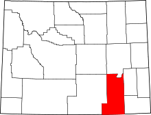 | |
| Town | ||
| CDPs | ||
| Unincorporated communities | ||