Shiga District, Shiga
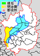
Map of Shiga District with Meiji period (1890) area in yellow.
Shiga (滋賀郡 Shiga-gun) was a district located in Shiga Prefecture, Japan.
As of 2003, the district has an estimated population of 21,964 and a density of 306.20 persons per km². The total area is 71.73 km².
On March 20, 2006, the town of Shiga was merged into the expanded city of Ōtsu. Shiga District was dissolved as a result of this merger. Historically, most of Ōtsu is now co-teminous with this district.
Transition
Light blue autonomies are Shiga District's town, deep blue autonomies are Shiga District's village, and gray autonomies are others.
| April 1, 1889 | 1889 - 1929 | 1930 - 1944 | 1945 - 1954 | 1955 - 1989 | 1990 - | Now | ||
|---|---|---|---|---|---|---|---|---|
| Ōtsu (大津) | October 1, 1898 Ōtsu City |
Ōtsu | April 1, 1933 Ōtsu |
Ōtsu | Ōtsu | Ōtsu | Ōtsu | |
| Shiga (滋賀) | Shiga | May 10, 1932 incorporation into Ōtsu | ||||||
| Zeze (膳所) | July 20, 1901 Zeze |
Zeze | ||||||
| Ishiyama (石山) | Ishiyama | January 1, 1930 Ishiyama | ||||||
| Sakamoto (坂本) | Sakamoto | Sakamoto | April 1, 1951 incorporation into Ōtsu | |||||
| Shimosakamoto (下阪本) | Shimosakamoto | Shimosakamoto | ||||||
| Ogoto (雄琴) | Ogoto | Ogoto | ||||||
| Katata (堅田) | July 20, 1901 Katata |
Katata | Katata | April 1, 1955 Katata |
April 1, 1967 incorporation into Ōtsu | |||
| Ōgi (仰木) | Ōgi | Ōgi | Ōgi | |||||
| Mano (真野) | Mano | Mano | Mano | |||||
| Ikadachi (伊香立) | Ikadachi | Ikadachi | Ikadachi | |||||
| Katsuragawa (葛川) | Katsuragawa | Katsuragawa | Katsuragawa | |||||
| Wani (和邇) | Wani | Wani | Wani | October 1, 1955 Shiga (志賀) |
March 20, 2006 incorporation into Ōtsu | |||
| Kido (木戸) | Kido | Kido | Kido | |||||
| Komatsu (小松) | Komatsu | Komatsu | Komatsu | |||||
This article is issued from Wikipedia - version of the 6/22/2015. The text is available under the Creative Commons Attribution/Share Alike but additional terms may apply for the media files.