Shipshewana, Indiana
| Shipshewana, Indiana | |
|---|---|
| Town | |
 | |
| Motto: "A Town Of Character"[1] | |
 Location of Shipshewana in the state of Indiana | |
| Coordinates: 41°40′37″N 85°34′48″W / 41.67694°N 85.58000°WCoordinates: 41°40′37″N 85°34′48″W / 41.67694°N 85.58000°W | |
| Country | United States |
| State | Indiana |
| County | LaGrange |
| Township | Newbury |
| Area[2] | |
| • Total | 1.18 sq mi (3.06 km2) |
| • Land | 1.18 sq mi (3.06 km2) |
| • Water | 0 sq mi (0 km2) |
| Elevation | 892 ft (272 m) |
| Population (2010)[3] | |
| • Total | 658 |
| • Estimate (2012[4]) | 666 |
| • Density | 557.6/sq mi (215.3/km2) |
| Time zone | Eastern (EST) (UTC-5) |
| • Summer (DST) | EDT (UTC-4) |
| ZIP code | 46565 |
| Area code(s) | 260 |
| FIPS code | 18-69480[5] |
| GNIS feature ID | 0443413[6] |
| Website | http://www.shipshewana.org/ |
Shipshewana is a town in Newbury Township, LaGrange County, Indiana, United States. The population was 658 at the 2010 census. It is the location of the Menno-Hof Amish & Mennonite Museum, which showcases the history of the Amish and Mennonite peoples.[7]
History
Shipshewana was named after a local Potawatomi Indian.[8] The Shipshewana post office was established in 1889.[9]
Geography
According to the 2010 census, Shipshewana has a total area of 1.18 square miles (3.06 km2), all land.[2]
Demographics
| Historical population | |||
|---|---|---|---|
| Census | Pop. | %± | |
| 1920 | 248 | — | |
| 1930 | 262 | 5.6% | |
| 1940 | 286 | 9.2% | |
| 1950 | 277 | −3.1% | |
| 1960 | 312 | 12.6% | |
| 1970 | 448 | 43.6% | |
| 1980 | 466 | 4.0% | |
| 1990 | 524 | 12.4% | |
| 2000 | 536 | 2.3% | |
| 2010 | 658 | 22.8% | |
| Est. 2015 | 684 | [10] | 4.0% |
2010 census
As of the census[3] of 2010, there were 658 people, 297 households, and 177 families residing in the town. The population density was 557.6 inhabitants per square mile (215.3/km2). There were 339 housing units at an average density of 287.3 per square mile (110.9/km2). The racial makeup of the town was 98.3% White, 0.2% African American, 0.5% Native American, 0.2% Asian, 0.3% from other races, and 0.6% from two or more races. Hispanic or Latino of any race were 0.8% of the population.
There were 297 households of which 26.9% had children under the age of 18 living with them, 47.1% were married couples living together, 9.8% had a female householder with no husband present, 2.7% had a male householder with no wife present, and 40.4% were non-families. 36.4% of all households were made up of individuals and 14.8% had someone living alone who was 65 years of age or older. The average household size was 2.22 and the average family size was 2.86.
The median age in the town was 37.7 years. 24.2% of residents were under the age of 18; 9.8% were between the ages of 18 and 24; 22.6% were from 25 to 44; 21.5% were from 45 to 64; and 22% were 65 years of age or older. The gender makeup of the town was 44.7% male and 55.3% female.
2000 census
As of the census[5] of 2000, there were 536 people, 235 households, and 149 families residing in the town. The population density was 582.7 people per square mile (224.9/km²). There were 251 housing units at an average density of 272.9 per square mile (105.3/km²). The racial makeup of the town was 97.57% White, 0.37% African American, 0.19% Native American, 0.19% from other races, and 1.68% from two or more races. Hispanic or Latino of any race were 1.12% of the population.
There were 235 households out of which 29.4% had children under the age of 18 living with them, 48.1% were married couples living together, 12.3% had a female householder with no husband present, and 36.2% were non-families. 33.6% of all households were made up of individuals and 17.4% had someone living alone who was 65 years of age or older. The average household size was 2.28 and the average family size was 2.86.
In the town the population was spread out with 24.1% under the age of 18, 12.7% from 18 to 24, 21.3% from 25 to 44, 23.9% from 45 to 64, and 18.1% who were 65 years of age or older. The median age was 36 years. For every 100 females there were 79.3 males. For every 100 females age 18 and over, there were 79.3 males.
The median income for a household in the town was $30,156, and the median income for a family was $53,214. Males had a median income of $36,875 versus $22,750 for females. The per capita income for the town was $26,270. About 6.0% of families and 8.0% of the population were below the poverty line, including 2.9% of those under age 18 and 20.8% of those age 65 or over.
Economy

In 2014, the Shipshewana-LaGrange County Convention and Visitor's Bureau commissioned a CERTEC study to gauge the impact of tourism. According to that study the tourism and travel industry contributed nearly $137.2 million[12] to the LaGrange County economy in 2013. Welcoming over 1 million visitors per year to the various attractions. Shipshewana is also a large producer of handcrafted Amish furniture. Amish furniture is noted for its durability, solid wood construction and simple elegance.
Arts and culture
Annual cultural events
- Pajama Sale (First Saturday each February)
- Mayfest (First Friday and Saturday each May)
- Pumpkinvine Bike Ride (Third Saturday in June)
- Shipshewana Antique Festival (First Saturday each August)
- Fall Crafters Fair (Second Friday and Saturday each October)
- Camp Shipshewana Summer camp (June through August)
- Shipshewana Quilt Festival (Fourth week each June)
Museums and other points of interest
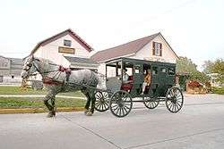
Shipshewana is perhaps most famous for its Miscellaneous and Antique Auction, held every Wednesday throughout the year. It also features the largest flea market in the midwest (Tuesday and Wednesday in season) as well as the Friday horse auction.

Although a very small town, Shipshewana is home to numerous antique and country-style decor shops and restaurants, especially with a strong Amish flavor. Attractions in Shipshewana include the Shipshewana Flea Market, Menno-Hof Amish History Museum , Blue Gate Restaurant and Theatre, The Davis Mercantile, Yoder's Department Store, Over 105 Specialty Stores in the Downtown Area, Hostetler's Hudson Museum and many events and festivals. These attractions, the Amish culture and the natural beauty of the area draw approximately 1.2 million visitors each year. Shipshewana is the only Indiana site listed in 1,000 Places to See Before You Die.
Parks and recreation
The town maintains a park system, including a soccer field complex, softball/baseball diamonds, and a general park/playground adjacent to the Wolfe Building on Morton Street.
Education
The town is served by the Westview School Corporation, in nearby Topeka, home of the Westview Warriors.[13]
References
- ↑ "Town of Shipshewana Indiana". Town of Shipshewana Indiana. Retrieved September 29, 2012.
- 1 2 "G001 - Geographic Identifiers - 2010 Census Summary File 1". United States Census Bureau. Retrieved 2015-07-25.
- 1 2 "American FactFinder". United States Census Bureau. Retrieved 2012-12-11.
- ↑ "Population Estimates". United States Census Bureau. Retrieved 2013-06-25.
- 1 2 "American FactFinder". United States Census Bureau. Retrieved 2008-01-31.
- ↑ "US Board on Geographic Names". United States Geological Survey. 2007-10-25. Retrieved 2008-01-31.
- ↑ "Menno-Hof - Amish/Mennonite Information Center". Menno-Hof - Amish/Mennonite Information Center. Retrieved September 29, 2012.
- ↑ "Profile for Shipshewana, Indiana, IN". ePodunk. Retrieved September 29, 2012.
- ↑ "LaGrange County". Jim Forte Postal History. Retrieved 9 December 2014.
- ↑ "Annual Estimates of the Resident Population for Incorporated Places: April 1, 2010 to July 1, 2015". Retrieved July 2, 2016.
- ↑ "Census of Population and Housing". Census.gov. Retrieved June 4, 2015.
- ↑ "Tourism in LaGrange County, Indiana". LaGrange County EDC. Shipshewana-LaGrange CVB. Retrieved 17 February 2016.
- ↑ "Westview School Corporation". Westview School Corporation. Retrieved September 29, 2012.
External links
| Wikimedia Commons has media related to Shipshewana, Indiana. |
- Shipshewana.com - Links to All Things Shipshewana!
- Municipal info for Town of Shipshewana, Indiana
- Pumpkinvine Nature Trail
- Westview School Corporation
- City-Data.com
Municipalities and communities of LaGrange County, Indiana, United States | ||
|---|---|---|
| Towns | ||
| Townships | ||
| CDP | ||
| Other unincorporated communities |
| |
| Footnotes | ‡This populated place also has portions in an adjacent county or counties | |