Siege of Fort-Louis (1793)
| Siege of Fort-Louis (1793) | |||||||
|---|---|---|---|---|---|---|---|
| Part of War of the First Coalition | |||||||
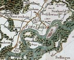
 Map of Fort-Louis by Cassini (1756–1815) | |||||||
| |||||||
| Belligerents | |||||||
|
|
| ||||||
| Commanders and leaders | |||||||
|
|
| ||||||
| Strength | |||||||
| 4,700, 55 guns | 4,500, 111 guns | ||||||
| Casualties and losses | |||||||
| unknown | 4,500, 5 colors | ||||||
The Siege of Fort-Louis (14 October – 14 November 1793) saw a force composed of Habsburg Austrians, Hessians and Bavarians led by Franz von Lauer lay siege to Fort-Louis which was held by a Republican French garrison under Michel Durand. The French capitulated after a defense lasting exactly one month. The siege occurred during the War of the First Coalition, part of the French Revolutionary Wars. In 1793 the fortress was sited on an island in the Rhine River, but today Fort-Louis is a village in the Bas-Rhin department in France.
Siege
General of Brigade Michel Durand's 4,500-strong garrison consisted of the 1st Battalions of the 4th Light, 37th Line and 40th Line Infantry Demi Brigades and the Strasbourg Volunteers, 3rd Battalions of the Gard and Saône-et-Loire Volunteers, and the 12th Battalion of the Vosges Volunteers. Dominique-André_de_Chambarlhac supervised the technical elements of the defense.[1] Altogether, Fort-Louis mounted 111 artillery pieces. General-major Franz von Lauer commanded the 4,700-man besieging force which included a siege train of 55 guns. Lauer commanded three battalions of the Combined Bavarian Regiment, one battalion from the Hessian Lieb Regiment, the Hessian Lieb Grenadier Battalion, one Austrian battalion from an unknown regiment and two squadrons of the Szekler Hussar Regiment.[2]
Notes
- ↑ (French) Jean-Baptiste-Pierre Courcelles,Dictionnaire universel de la noblesse de France, Au Bureau général de la noblesse de France,1822, pp. 73–74.
- ↑ Smith, Digby (1998). The Napoleonic Wars Data Book. London: Greenhill. p. 61. ISBN 1-85367-276-9.
References
- Smith, Digby (1998). The Napoleonic Wars Data Book. London: Greenhill. ISBN 1-85367-276-9.
- "The Fortifications of Vauban: Fort-Louis". Unesco World Heritage. 2010. Retrieved 1 March 2014.
Coordinates: 48°48′7″N 8°3′26″E / 48.80194°N 8.05722°E