Sirdal
| Sirdal kommune | |||
|---|---|---|---|
| Municipality | |||
|
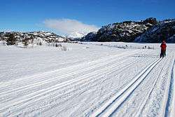
Ski-tracks in Sirdal | |||
| |||
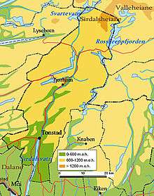
 Sirdal within Vest-Agder | |||
| Coordinates: 58°51′43″N 06°48′48″E / 58.86194°N 6.81333°ECoordinates: 58°51′43″N 06°48′48″E / 58.86194°N 6.81333°E | |||
| Country | Norway | ||
| County | Vest-Agder | ||
| District | Lister | ||
| Administrative centre | Tonstad | ||
| Government | |||
| • Mayor (2015) | Thor Jørgen Tjørhom (Sp) | ||
| Area | |||
| • Total | 1,554.83 km2 (600.32 sq mi) | ||
| • Land | 1,375.18 km2 (530.96 sq mi) | ||
| • Water | 179.65 km2 (69.36 sq mi) | ||
| Area rank | 47 in Norway | ||
| Population (2016) | |||
| • Total | 1,832 | ||
| • Rank | 343 in Norway | ||
| • Density | 1.3/km2 (3/sq mi) | ||
| • Change (10 years) | 5.3 % | ||
| Demonym(s) | Sirdøl[1] | ||
| Time zone | CET (UTC+1) | ||
| • Summer (DST) | CEST (UTC+2) | ||
| ISO 3166 code | NO-1046 | ||
| Official language form | Neutral | ||
| Website |
www | ||
|
| |||


Sirdal is a municipality in Vest-Agder county, Norway. It is located in the northwestern part of the traditional district of Lister. The administrative centre of the municipality is the village of Tonstad. Other villages in Sirdal include Bjørnestad, Haughom, Kvæven, Lunde, and Tjørhom.
General information

The old parish of Sirdal was first established as a municipality in 1849 when it was separated from the large municipality of Bakke. Initially, Sirdal had 1,804 residents. On 1 January 1903, a small area of Sirdal (population: 63) was transferred to the neighboring municipality of Fjotland. On 1 January 1905, the municipality of Sirdal was dissolved and its territories were divided into two new municipalities: Tonstad (population: 828) and Øvre Sirdal (population: 753). These large, sparsely populated municipalities merged along with the Øksendal area of Bakke municipality to recreate the municipality of Sirdal on 1 January 1960. This time, Sirdal started out with a population of 1,426. On 1 January 1987, the Virak and Espetveit areas of northern Flekkefjord (population: 41) were transferred to Sirdal municipality.[2]
Name
The municipality is named after the Sirdalen valley which runs through it. The Old Norse form of the name was Sírudalr. The first element is the genitive case of the river name Síra (now the Sira river). The last element is dalr which means "valley" or "dale". The meaning of the river name is unknown (maybe "strong stream").[3]
Coat-of-arms
The coat-of-arms is from modern times; they were granted on 17 January 1986. The arms show three white-colored willow ptarmigans (Lagopus lagopus) on a green background. The birds were chosen as a symbol for the hills and moors which make up the largest part of the municipality. The willow ptarmigan is a typical bird for the area.[4]
Churches
The Church of Norway has one parish (sokn) within the municipality of Sirdal. It is part of the Lister deanery in the Diocese of Agder og Telemark.
| Parish (Sokn) | Church Name | Location of the Church | Year Built |
|---|---|---|---|
| Sirdal | Haughom Chapel | Haughom | 1930 |
| Kvævemoen Chapel | Kvæven | 1962 | |
| Lunde Church | Lunde | 1873 | |
| Tonstad Church | Tonstad | 1852 |
Geography
Sirdal municipality includes the northernmost valley in Vest-Agder county, bordering Aust-Agder county to the northeast and Rogaland county to the west. To the south, it borders on the municipality of Flekkefjord and to the east is Kvinesdal. Sirdal is the largest area municipality in Vest-Agder. Lakes in the region include Gravatnet, Kulivatnet, Kvifjorden, Øyarvatnet, Rosskreppfjorden, Sirdalsvatnet, and Valevatn. The mountain Urddalsknuten lies at the northern end of the municipality.
In 1990, the mountain road opened between the Sirdalen valley and the Setesdal valley over the Suleskard mountain pass. It connected Sirdal to Brokke in the neighboring municipality of Valle to the east. It shortened the distance from Oslo to Stavanger by 110 kilometres (68 mi) in the summer, and the road passes through barren, glacier-scoured highland. As it passes by the Rosskreppfjorden, it ascends to over 1,000 metres (3,300 ft) above sea level.[5]
Climate
| Climate data for Tonstad | |||||||||||||
|---|---|---|---|---|---|---|---|---|---|---|---|---|---|
| Month | Jan | Feb | Mar | Apr | May | Jun | Jul | Aug | Sep | Oct | Nov | Dec | Year |
| Daily mean °C (°F) | −2.0 (28.4) |
−2.2 (28) |
0.8 (33.4) |
4.4 (39.9) |
9.8 (49.6) |
13.4 (56.1) |
15.0 (59) |
14.4 (57.9) |
10.7 (51.3) |
6.9 (44.4) |
2.3 (36.1) |
−1.3 (29.7) |
6.0 (42.8) |
| Average precipitation mm (inches) | 185 (7.28) |
131 (5.16) |
139 (5.47) |
74 (2.91) |
102 (4.02) |
99 (3.9) |
109 (4.29) |
147 (5.79) |
213 (8.39) |
248 (9.76) |
239 (9.41) |
204 (8.03) |
1,890 (74.41) |
| Source: Norwegian Meteorological Institute[6] | |||||||||||||
Government


All municipalities in Norway, including Sirdal, are responsible for primary education (through 10th grade), outpatient health services, senior citizen services, unemployment and other social services, zoning, economic development, and municipal roads. The municipality is governed by a municipal council of elected representatives, which in turn elect a mayor.
Municipal council
The municipal council (Kommunestyre) of Sirdal is made up of 19 representatives that are elected to every four years. Currently, the party breakdown is as follows:[7]
| Party Name | Name in Norwegian | Number of representatives | |
|---|---|---|---|
| Labour Party | Arbeiderpartiet | 6 | |
| Conservative Party | Høyre | 3 | |
| Christian Democratic Party | Kristelig Folkeparti | 3 | |
| Centre Party | Senterpartiet | 4 | |
| Liberal Party | Venstre | 1 | |
| Local Lists | Lokale lister | 2 | |
| Total number of members: | 19 | ||
Economy
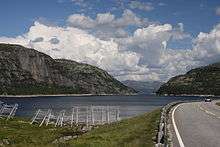

The main source of income for Sirdal is the Sira-Kvina Power Company which gets its power from the big Sira and Kvina rivers. The waterfalls on the river Sira are utilized in four power stations owned by Sira-Kvina power company. The company also owns three power stations in the Kvina river system, hence the company's name. Total annual production is 6,000 gigawatt-hours (22,000 TJ), total installation is 1,760 megawatts (2,360,000 hp). The largest power station, Tonstad Hydroelectric Power Station, was inaugurated in 1968, with two units, each producing 160 megawatts (210,000 hp). The power station has now 4 units, each 160 MW, and one unit at 320 megawatts (430,000 hp), giving a total output of 960 megawatts (1,290,000 hp). Total annual production in this station is approximately 4,000 gigawatt-hours (14,000 TJ), which makes Tonstad the largest power station in Norway in terms of production. Sira-Kvina power company applied in 2007 for concession to expand the power station with two new units (reversible turbines), each containing 480 megawatts (640,000 hp), and the concession is pending.[8]
Tourism is also an important source of income for the Sirdal economy, taking advantage of the extensive mountains, mountainous plateaus, lakes, and great views. There are multiple alpine resorts and hotels in the valley, as well as cottages and camping spots. Winter activities include six ski resorts for winter enjoyment. Downhill ski areas include Tjørhomfjellet, Bjørnestad Ski Centre, Ålsheia Ski Centre, Fidjeland Ski Centre, and Ådneram Ski lift. Cross-country skiers can enjoy dozens of trails over spectacular terrain. Summer activities include hiking, horseback riding, and river rafting.[8]
History
From the oldest times the Sirdalen valley was divided by the river Sira with Rogaland county controlling the west side and Vest-Agder county controlling the east side. The two sides of the valley, however, was established as one single parish in Christian times, even though it crossed county lines, something that was not very common in Norway.
In 1837, it was decided that every parish should be a municipality, but no municipality should belong to more than one county (see formannskapsdistrikt). Sirdal parish was therefore first divided in two municipalities. This was a bad decision because they had very few inhabitants separately. A new solution was found in 1839 when the two municipalities were re-joined together, and the county border was moved so that all of Sirdalen was in Vest-Agder county.
At Kvæven, in northern Sirdal one finds the Sirdal Mountain Museum. This museum has a collection of old Sirdal buildings. Former lifestyles are visible in the farmhouse, a schoolhouse, stable, blacksmith's shop, barn, and mountain farm cottage as well as original equipment.
Notable residents
- Linda Grubben, a female World Cup biathlete
- Arild Haugen, a boxer and former strongman
International relations
Twin towns — Sister cities
 Väike-Maarja Parish, Estonia (since 1994)[9]
References
- ↑ "Navn på steder og personer: Innbyggjarnamn" (in Norwegian). Språkrådet. Retrieved 2015-12-01.
- ↑ Jukvam, Dag (1999). "Historisk oversikt over endringer i kommune- og fylkesinndelingen" (PDF) (in Norwegian). Statistisk sentralbyrå.
- ↑ Rygh, Oluf (1912). Norske gaardnavne: Lister og Mandals amt (in Norwegian) (9 ed.). Kristiania, Norge: W. C. Fabritius & sønners bogtrikkeri. pp. 328–329.
- ↑ "Civic heraldry of Norway - Norske Kommunevåpen". Heraldry of the World. Retrieved 2016-08-18.
- ↑ Welle-Strand, Erling (1996). Adventure Roads in Norway. Nortrabooks. ISBN 9788290103717.
- ↑ "eKlima Web Portal". Norwegian Meteorological Institute.
- ↑ "Table: 04813: Members of the local councils, by party/electoral list at the Municipal Council election (M)" (in Norwegian). Statistics Norway. 2015.
- 1 2 Stagg, Frank Noel (1958). South Norway. George Allen & Unwin, Ltd.
- ↑ "Sõprusvallad" (in Estonian). Väike-Maarja vald. Retrieved 21 March 2011.
External links
| Wikimedia Commons has media related to Sirdal. |
| Look up Sirdal in Wiktionary, the free dictionary. |
 Vest-Agder travel guide from Wikivoyage
- Map of Sirdal
- Sirdal Mountain Museum
- Sirdal Mountain Museum, Official Website (Norwegian)
- SirdalsNett - All you need to know about Sirdal (Norwegian)
- Sirdalsferie - Information for tourists
- Sirdal kommune (Norwegian)
- To & From Sirdal Transport Map