Sironko District
| Sironko District | |
|---|---|
| District | |
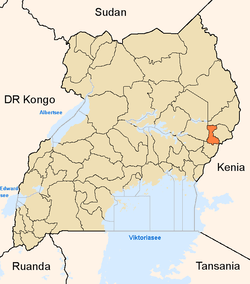 District location in Uganda | |
| Coordinates: 01°14′N 34°15′E / 1.233°N 34.250°ECoordinates: 01°14′N 34°15′E / 1.233°N 34.250°E | |
| Country |
|
| Region | Eastern Uganda |
| Sub-region | Bugisu sub-region |
| Capital | Sironko |
| Area | |
| • Land | 446.1 km2 (172.2 sq mi) |
| Elevation | 1,420 m (4,660 ft) |
| Population (2012 Estimate) | |
| • Total | 239,600 |
| • Density | 537.1/km2 (1,391/sq mi) |
| Time zone | EAT (UTC+3) |
| Website |
www |
Sironko District is a district in Eastern Uganda. The district was created in 2000 and had previously been part of Mbale District. Like most Ugandan districts, it is named after its main commercial town, Sironko.
Location
Sironko District is bordered by Bulambuli District to the north, Kapchorwa District and Kween District to the northeast, the Republic of Kenya to the east, Bududa District to the southeast, Mbale District to southwest and Bukedea District to the west. Its 'chief town', Sironko, is located approximately 22 kilometres (14 mi), by road, northeast of Mbale, the largest city in the sub-region.[1] The coordinates of the district are:01 14N, 34 15E.
Population
In 1991, the national population census estimated the district population at about 147,700. The national census in 2002 estimated the population of the district at about 185,800, with an annual population growth rate of 2.6%. It is estimated that the population of the district in 2012 was approximately 239,600.[2] The majority of the people in Sironko District belong to the Bagisu ethnic group, and Lugisu is the most widely spoken language.
Geography
The district has a total area of 446.1 square kilometres (172.2 sq mi).[3] The district lies between approximately 1,299 metres (4,262 ft) and 1,524 metres (5,000 ft) above sea level.
Major towns
Sironko is the largest town and the administrative headquarters. Mafuni, Nakaloke, Mutufu and Budadiri are the main trading centers within the district.
Counties, sub-counties and constituencies
Budadiri County is the only county in the district.[4][5] The district is divided into two parliamentary constituencies: Budadiri East and Budadiri West. Budadiri County is subdivided into the following sub-counties:
- Bugusege
- Buhugu
- Buteza
- Buyobo
- Bukhulo
- Bumasifwa
- Busulani
- Butandiga
- Buwalasi
- Zesui
Economy
The primary activity is agriculture with a focus on food crops such as beans, groundnuts, sorghum, millet, cassava, potatoes and sweet potatoes. Coffee and cotton are the main cash crops. Fruits and vegetables grown in the district include passion fruit, tomatoes, onions and cabbage.[6]
Tourist attractions
Part of Mount Elgon National Park lies within Sironko district. One of the two main trails in the park, Sasa trail, starts near the Budadiri trading center located within the district.[7]
See also
References
- ↑ "Map Showing Mbale And Sironko With Distance Marker". Globefeed.com. Retrieved 20 May 2014.
- ↑ "Estimated Population of Sironko District In 1991, 2002 & 2012". Citypopulation.de. Retrieved 20 May 2014.
- ↑ ., . (2012). "Estimated Land Area In Sironko District". Citypopulation.de. Retrieved 20 May 2014.
- ↑ Districts of Uganda, Statoids, accessed 3 August 2015
- ↑ Counties of Uganda, Statoids, accessed 3 August 2015
- ↑ "Economic Activity In Sironko District". Uganda Travel Bureau. Retrieved 20 May 2014.
- ↑ Spectrum guide to Uganda, Interlink Books, 1998, p. 156. ISBN 1-56656-270-8.