Smyrna Airport (Tennessee)
| Smyrna Airport | |||||||||||||||
|---|---|---|---|---|---|---|---|---|---|---|---|---|---|---|---|
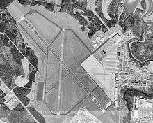 USGS aerial image, February 1999 | |||||||||||||||
| IATA: MQY – ICAO: KMQY – FAA LID: MQY | |||||||||||||||
| Summary | |||||||||||||||
| Airport type | Public | ||||||||||||||
| Owner | Smyrna / Rutherford County Airport Authority | ||||||||||||||
| Serves | Smyrna, Tennessee | ||||||||||||||
| Elevation AMSL | 543 ft / 166 m | ||||||||||||||
| Coordinates | 36°00′32″N 086°31′12″W / 36.00889°N 86.52000°WCoordinates: 36°00′32″N 086°31′12″W / 36.00889°N 86.52000°W | ||||||||||||||
| Map | |||||||||||||||
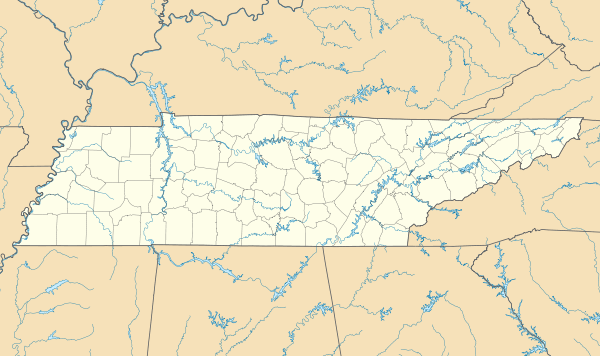 MQY  MQY Location of airport in Tennessee/United States | |||||||||||||||
| Runways | |||||||||||||||
| |||||||||||||||
| Helipads | |||||||||||||||
| |||||||||||||||
| Statistics (2010) | |||||||||||||||
| |||||||||||||||
Smyrna Airport (IATA: MQY, ICAO: KMQY, FAA LID: MQY) is a public general aviation and military use airport located two nautical miles (4 km) north of the central business district of Smyrna, a town in Rutherford County, Tennessee, United States. It is owned by Smyrna / Rutherford County Airport Authority.[1] Smyrna Airport is the third largest airport in Tennessee and is the state's busiest general aviation airport. Prior to March 1971, the facility was an active military installation known as Sewart Air Force Base.
This airport is included in the National Plan of Integrated Airport Systems for 2011–2015, which categorized it as a reliever airport[2] for Nashville International Airport, which is located twelve nautical miles (22 km) to the north.
Military use
Smyrna Airport currently operates as a joint use facility with a Tennessee Army National Guard helicopter unit, Army Aviation Support Facility #1 (AASF#1), which operates 60 helicopters with 300 full-time Army National Guard personnel.
The airport previously served as an outlying Air National Guard training facility for C-130 Hercules aircraft of the 118th Airlift Wing (now redesignated the 118th Wing) of the Tennessee Air National Guard at Berry Field Air National Guard Base at Nashville International Airport until the wing's termination of C-130 operations in 2012. The airport also continues to support training operations by C-17 Globemaster III aircraft of the Tennessee Air National Guard's 164th Airlift Wing at Memphis Air National Guard Base at the Memphis International Airport.
The Tennessee Army National Guard also leases part of the airport to maintain the Grubbs/Kyle Training Center. This facility supports 24 different units and 1,270 assigned Army National Guard personnel, 162 of which are full-time, as well as numerous military aircraft.
Facilities and aircraft
Smyrna Airport covers an area of 1,700 acres (688 ha) at an elevation of 543 feet (166 m) above mean sea level. It has two asphalt paved runways 14/32 is 8,048 by 150 feet (2,453 x 46 m) and 1/19 is 5,546 by 100 feet (1,690 x 30 m). It also has one helipad designated H1 with a concrete surface measuring 40 by 40 feet (12 x 12 m).[1]
For the 12-month period ending December 31, 2010, the airport had 61,597 aircraft operations, an average of 168 per day: 84% general aviation, 14% military, 2% air taxi, and <1% scheduled commercial. At that time there were 199 aircraft based at this airport: 48% single-engine, 21% multi-engine, 14% jet, 1% helicopter, 1% glider, and 15.% military.[1]
The airport has an operational control tower twelve (12) hours a day, precision instrument landing system (ILS) approaches to Runway 14 and Runway 32, and DoD Into-Plane Contract jet fuel for military and other US Government aircraft provided by the on-site civilian fixed-base operator (FBO), Smyrna Air Center.
Airlines and Destinations
| Airlines | Destinations |
|---|---|
| Sun Country Airlines | Charter: Gulfport/Biloxi |
References
- 1 2 3 4 FAA Airport Master Record for MQY (Form 5010 PDF). Federal Aviation Administration. Effective August 25, 2011.
- ↑ "2011–2015 NPIAS Report, Appendix A (PDF, 2.03 MB)" (PDF). National Plan of Integrated Airport Systems. Federal Aviation Administration. October 4, 2010. External link in
|work=(help)
External links
| Wikimedia Commons has media related to Smyrna Airport, Tennessee. |
- Smyrna/Rutherford County Airport
- Smyrna Air Center FBO
- Aerial image as of February 1999 from USGS The National Map
- FAA Terminal Procedures for MQY, effective December 8, 2016
- FAA Airport Diagram (PDF), effective December 8, 2016
- Resources for this airport:
- FAA airport information for MQY
- AirNav airport information for KMQY
- ASN accident history for MQY
- FlightAware airport information and live flight tracker
- NOAA/NWS latest weather observations
- SkyVector aeronautical chart, Terminal Procedures