Snillfjord
| Snillfjord kommune | |||
|---|---|---|---|
| Municipality | |||
| |||
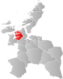 Snillfjord within Sør-Trøndelag | |||
| Coordinates: 63°25′29″N 9°26′5″E / 63.42472°N 9.43472°ECoordinates: 63°25′29″N 9°26′5″E / 63.42472°N 9.43472°E | |||
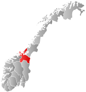
| Country | Norway | ||
| County | Sør-Trøndelag | ||
| District | Fosen | ||
| Administrative centre | Krokstadøra | ||
| Government | |||
| • Mayor (2007) | John Lernes (H) | ||
| Area | |||
| • Total | 508.31 km2 (196.26 sq mi) | ||
| • Land | 489.12 km2 (188.85 sq mi) | ||
| • Water | 19.19 km2 (7.41 sq mi) | ||
| Area rank | 207 in Norway | ||
| Population (2010) | |||
| • Total | 998 | ||
| • Rank | 407 in Norway | ||
| • Density | 2.0/km2 (5/sq mi) | ||
| • Change (10 years) | -8.7 % | ||
| Demonym(s) | Snillfjording[1] | ||
| Time zone | CET (UTC+1) | ||
| • Summer (DST) | CEST (UTC+2) | ||
| ISO 3166 code | NO-1613 | ||
| Official language form | Neutral | ||
| Website |
www | ||
|
| |||

Snillfjord is a municipality in Sør-Trøndelag county, Norway. It is part of the Fosen region. The administrative centre of the municipality is the village of Krokstadøra. Other villages in Snillfjord include Ytre Snillfjord, Hemnskjela, and Vutudal.
General information
The municipality of Snillfjord was established on 1 July 1924 when it was separated from Hemne. The initial population was 776. On 1 January 1964, the eastern part of Heim (population: 724) and the western part of Agdenes (population: 196) was merged with Snillfjord (population: 681) to form a new, larger municipality of Snillfjord. On 1 January 1995, the Midtun area of Agdenes (population: 21) was transferred to Snillfjord. A road to the area had recently been built, but it connected to Snillfjord and not Agdenes, so it was decided to switch to the other municipality due to the newly opened road connection.[2]
Name
The municipality is named after the Snillfjorden. The first element is probably an old river name of the Snilldalselva. The river name is derived from snild which comes from the word snjallr which means "fast" (related to German schnell).[3][4]
Coat-of-arms
The coat-of-arms is from modern times. They were adopted on 19 September 1990. The arms show a silver pitchfork pointing down on a green background. It symbolizes the importance of agriculture in the municipality.[5]
Churches
The Church of Norway has one parish (sokn) within the municipality of Snillfjord. It is part of the Deanery (prosti) of Orkdal and the Diocese of Nidaros.
| Parish (Sokn) | Church Name | Year Built | Location of the Church |
|---|---|---|---|
| Snillfjord | Snillfjord kirke | 1898 | Krokstadøra |
Geography
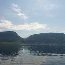
The municipality of Snillfjord lies south of the Trondheimsleia and east of the Hemnfjorden. The Åstfjorden and Snillfjorden flow east from the Hemnfjorden into the municipality. The lake Våvatnet lies on the border with Orkdal in the southeast. The island of Hemnskjela lies in the Trondheimsleia in the north, and it is the southern entrance to the Hitra Tunnel.
The 508-square-kilometre (196 sq mi) municipality of Snillfjord is surrounded by four municipalities. The municipality of Hemne lies to the southwest, Hitra is to the northwest, Agdenes to the northeast, and Orkdal to the southeast.
References
- ↑ "Navn på steder og personer: Innbyggjarnamn" (in Norwegian). Språkrådet. Retrieved 2015-12-01.
- ↑ Jukvam, Dag (1999). "Historisk oversikt over endringer i kommune- og fylkesinndelingen" (PDF) (in Norwegian). Statistisk sentralbyrå.
- ↑ Rygh, Oluf (1901). Norske gaardnavne: Søndre Trondhjems amt (in Norwegian) (14 ed.). Kristiania, Norge: W. C. Fabritius & sønners bogtrikkeri. pp. 91+92.
- ↑ Store norske leksikon. "Snillfjord" (in Norwegian). Retrieved 2011-01-24.
- ↑ "Faktaopplysninger" (in Norwegian). Snillfjord kommune. Retrieved 2008-10-29.
External links
| Wikimedia Commons has media related to Snillfjord. |
 Sør-Trøndelag travel guide from Wikivoyage
- Municipal fact sheet from Statistics Norway