Rissa, Norway
| Rissa kommune | |||
|---|---|---|---|
| Municipality | |||
 | |||
| |||
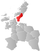 Rissa within Sør-Trøndelag | |||
| Coordinates: 63°39′20″N 10°2′23″E / 63.65556°N 10.03972°ECoordinates: 63°39′20″N 10°2′23″E / 63.65556°N 10.03972°E | |||
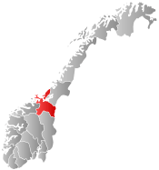
| Country | Norway | ||
| County | Sør-Trøndelag | ||
| District | Fosen | ||
| Administrative centre | Årnset | ||
| Government | |||
| • Mayor (2011) | Ove Vollan (H) | ||
| Area | |||
| • Total | 621.61 km2 (240.00 sq mi) | ||
| • Land | 588.05 km2 (227.05 sq mi) | ||
| • Water | 33.56 km2 (12.96 sq mi) | ||
| Area rank | 178 in Norway | ||
| Population (2010) | |||
| • Total | 6,442 | ||
| • Rank | 157 in Norway | ||
| • Density | 11.0/km2 (28/sq mi) | ||
| • Change (10 years) | -0.9 % | ||
| Demonym(s) | Rissværing[1] | ||
| Time zone | CET (UTC+1) | ||
| • Summer (DST) | CEST (UTC+2) | ||
| ISO 3166 code | NO-1624 | ||
| Official language form | Neutral | ||
| Website |
www | ||
|
| |||

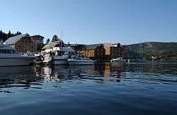
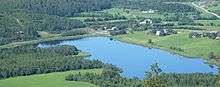
Rissa is a municipality in Sør-Trøndelag county, Norway. It is part of the Fosen region. The administrative centre of the municipality is the village of Årnset. Other villages in the municipality include Askjem, Hasselvika, Husbysjøen, Rørvika, Råkvåg, and Stadsbygd.
General information
The municipality of Rissen was established in 1860 when it was separated from the big municipality of Stadsbygd. Initially, Rissen had 3,733 residents. The spelling was later changed to Rissa. On 1 January 1905, the district of Lensvik (population: 1,019) on the west side of the Trondheimsfjord was separated from Rissa to form a municipality of its own. This left Rissa with 3,394 residents. On 1 January 1964, most of Stadsbygd (except the Ingdalen area) and the southern part of Stjørna were merged with Rissa to form a new, enlarged municipality of Rissa.[2]
Name
The Old Norse form of the name was Rissi. This was probably the old name of the brackish basin of Botn (literally "the bottom" of the fjord). Even though this is a heavily land-locked fjord with a river-like inlet from the Trondheimsfjord (it was probably a shallow bay in prehistoric times). The name is probably derived from the verb rísa which means "raise" or "rise". (The average water level of Botnen is today about 1.7 metres (5 ft 7 in) above mean sea level and the surface water is almost fresh from accumulated internal runoff.) The name of the municipality was historically spelled Rissen.[3]
Coat-of-arms
The coat-of-arms is from modern times. They were granted on 23 January 1987. The arms show a silver crown on a green background. The crown is that of Skule Bårdsson as it is depicted on an old tombstone at the Nidaros Cathedral. Bårdsson was the founder of Rein kloster and the accompanying farm and Rein estate, which lies in the municipality. The crown is a typical headdress used by the medieval Norwegian Dukes.[4]
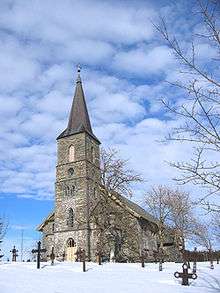
Churches
The Church of Norway has four parishes (sokn) within the municipality of Rissa. It is part of the Deanery (prosti) of Fosen and the Diocese of Nidaros.
| Parish (Sokn) | Church Name | Year Built | Location of the Church |
|---|---|---|---|
| Hasselvika | Hasselvika kirke | 1951 | Hasselvika |
| Rissa | Rissa kirke | 1888 | Leira |
| Rein kirke | 1932 | Reinsgrenda | |
| Stadsbygd | Stadsbygd kirke | 1842 | Stadsbygd |
| Sør-Stjørna | Ramsvik kirke | 1909 | Råkvåg |
| Frengen kirke | 1972 | Frengen |
History
In April 1978, Rissa was home to a quick-clay landslide which encompassed an area of 330,000 square metres (3,600,000 sq ft) and sent 6,000,000 cubic metres (7,800,000 cu yd) of clay from the Årnset area on the shore into Botn, causing a miniature tsunami on the north shore in Leira. This slide is particularly famous because a large portion of the slide happened to be recorded on film by two amateur photographers.
Geography
The municipality is located on the southern end of the Fosen peninsula along the Trondheimsfjord and the Stjørnfjord. The large lake Storvatnet lies on the eastern border with Lensvik. To the north lie the municipalities of Åfjord, Bjugn, and Ørland.
The Flakk–Rørvik Ferry crosses the Trondheimsfjord and connects Rørvik with Trondheim.
References
- ↑ "Navn på steder og personer: Innbyggjarnamn" (in Norwegian). Språkrådet. Retrieved 2015-12-01.
- ↑ Jukvam, Dag (1999). "Historisk oversikt over endringer i kommune- og fylkesinndelingen" (PDF) (in Norwegian). Statistisk sentralbyrå.
- ↑ Rygh, Oluf (1901). Norske gaardnavne: Søndre Trondhjems amt (in Norwegian) (14 ed.). Kristiania, Norge: W. C. Fabritius & sønners bogtrikkeri. p. 101.
- ↑ Norske Kommunevåpen (1990). "Nye kommunevåbener i Norden". Retrieved 27 October 2008.
External links
| Wikimedia Commons has media related to Rissa (Sør-Trøndelag). |
 Sør-Trøndelag travel guide from Wikivoyage
- Municipal fact sheet from Statistics Norway