Sokndal
| Sokndal kommune | |||
|---|---|---|---|
| Municipality | |||
|
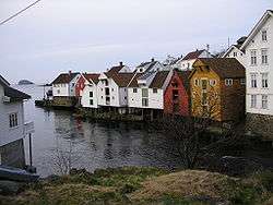
View of Sogndalsstranda | |||
| |||
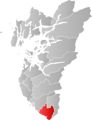 Sokndal within Rogaland | |||
| Coordinates: 58°21′54″N 06°18′37″E / 58.36500°N 6.31028°ECoordinates: 58°21′54″N 06°18′37″E / 58.36500°N 6.31028°E | |||
| Country | Norway | ||
| County | Rogaland | ||
| District | Dalane | ||
| Administrative centre | Hauge i Dalene | ||
| Government | |||
| • Mayor (2011) | Trond Arne Pedersen (KrF) | ||
| Area | |||
| • Total | 294.97 km2 (113.89 sq mi) | ||
| • Land | 267.15 km2 (103.15 sq mi) | ||
| • Water | 27.82 km2 (10.74 sq mi) | ||
| Area rank | 280 in Norway | ||
| Population (2016) | |||
| • Total | 3,313 | ||
| • Rank | 255 in Norway | ||
| • Density | 12.4/km2 (32/sq mi) | ||
| • Change (10 years) | 0.4 % | ||
| Demonym(s) | Sokndøl[1] | ||
| Time zone | CET (UTC+1) | ||
| • Summer (DST) | CEST (UTC+2) | ||
| ISO 3166 code | NO-1111 | ||
| Official language form | Neutral | ||
| Website |
www | ||
|
| |||

Sokndal is the southernmost municipality in Rogaland county, Norway. It is located in the traditional district of Dalane. The administrative centre of the municipality is the village of Hauge. Other villages in Sokndal include Li, Rekefjord, Sogndalsstranda, and Åna-Sira.
Sogndalsstranda is a picturesque, old fishing village, which may have inspired the municipality in becoming Norway's first member of Cittaslow. The Jøssingfjorden, known for the Altmark Incident, is also located in Sokndal.
General information

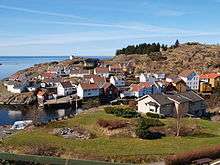
_(6005538066).jpg)
The parish of Soggendal (later Sokndal) was established as a municipality on 1 January 1838 (see formannskapsdistrikt). In 1845, the small lading place of Sogndal (population: 348) was separated from Sokndal as a municipality of its own. This left Sokndal with 2,819 residents. On 12 December 1868, a small part of Sokndal (population: 41) was transferred to neighboring Eigersund municipality. On 1 July 1944, the small lading place of Sogndal (population: 311) was reincorporated into Sokndal. In 1947, a small area in Sokndal (population: 7) was transferred to Eigersund. On 1 January 1967, the Tjørn farm (population: 10) was transferred from Eigersund to Sokndal.[2]
Name
The Old Norse form of the name was Sóknardalr. The first element is the genitive case of the river name Sókn (now Sokno) and the last element is dalr which means "valley" or "dale". The river name is derived from the Old Norse verb sœkja which means "seek" and so the meaning is "the river which seeks (finds/forces) its way". Before 1918, the name was written "Sogndal" or "Soggendahl".[3]
Coat-of-arms
The coat-of-arms is from modern times; they were granted on 8 July 1988. The arms show three black pickaxes on a yellow background. These were chosen to symbolize the importance of mining and agriculture in the municipality. It was designed by Johan Digernes of Haugesund.[4]
Churches
The Church of Norway has one parish (sokn) within the municipality of Sokndal. It is part of the Dalane deanery in the Diocese of Stavanger.
| Parish (Sokn) | Church Name | Location of the Church | Year Built |
|---|---|---|---|
| Sokndal | Sokndal Church | Hauge | 1803 |
| Åna-Sira Church | Åna-Sira | 1888 |
Geography
The municipality is the southernmost in Rogaland county. The North Sea lies to the south and west, the river Sira and the Åna fjord lie to the southeast (separating it from Flekkefjord in Vest-Agder county), the municipality of Lund lies to the east and north, and the municipality of Eigersund lies to the northwest. The lakes Grøsfjellvatnet and Eiavatnet both lie on the northern border of the municipality. The coastline of Sokndal is fairly smooth, although there are two larger fjords which cut into the municipality: the Rekefjorden and Jøssingfjorden. The Lille Presteskjær Lighthouse marks the entrance to the Rekefjorden. The southeastern part of the municipality is very rocky and rugged. It is the site of the large Tellnes mine, a large producer of titanium.[5]
Climate
| Climate data for Hauge | |||||||||||||
|---|---|---|---|---|---|---|---|---|---|---|---|---|---|
| Month | Jan | Feb | Mar | Apr | May | Jun | Jul | Aug | Sep | Oct | Nov | Dec | Year |
| Daily mean °C (°F) | −0.3 (31.5) |
−0.5 (31.1) |
1.6 (34.9) |
4.7 (40.5) |
9.7 (49.5) |
13.1 (55.6) |
14.6 (58.3) |
14.4 (57.9) |
11.3 (52.3) |
8.2 (46.8) |
3.9 (39) |
0.9 (33.6) |
6.8 (44.2) |
| Average precipitation mm (inches) | 150 (5.91) |
105 (4.13) |
120 (4.72) |
85 (3.35) |
93 (3.66) |
98 (3.86) |
118 (4.65) |
150 (5.91) |
190 (7.48) |
210 (8.27) |
193 (7.6) |
163 (6.42) |
1,675 (65.94) |
| Source: Norwegian Meteorological Institute[6] | |||||||||||||
Economy

At Tellnes, just east of Hauge i Dalane, there is an ilmenite mine run by Titania AS, supplying 10% of the world production of ilmenite (a type of titanium). It's also the world's largest opencast ilmenite mine.
Government
All municipalities in Norway, including Sokndal, are responsible for primary education (through 10th grade), outpatient health services, senior citizen services, unemployment and other social services, zoning, economic development, and municipal roads. The municipality is governed by a municipal council of elected representatives, which in turn elect a mayor.
Municipal council
The municipal council (Kommunestyre) of Sokndal is made up of 21 representatives that are elected to every four years. Currently, the party breakdown is as follows:[7]
| Party Name | Name in Norwegian | Number of representatives | |
|---|---|---|---|
| Labour Party | Arbeiderpartiet | 7 | |
| Progress Party | Fremskrittspartiet | 2 | |
| Conservative Party | Høyre | 3 | |
| Christian Democratic Party | Kristelig Folkeparti | 6 | |
| Centre Party | Senterpartiet | 1 | |
| Liberal Party | Venstre | 2 | |
| Total number of members: | 21 | ||
References
- ↑ "Navn på steder og personer: Innbyggjarnamn" (in Norwegian). Språkrådet. Retrieved 2015-12-01.
- ↑ Jukvam, Dag (1999). "Historisk oversikt over endringer i kommune- og fylkesinndelingen" (PDF) (in Norwegian). Statistisk sentralbyrå.
- ↑ Rygh, Oluf (1915). Norske gaardnavne: Stavanger amt (in Norwegian) (10 ed.). Kristiania, Norge: W. C. Fabritius & sønners bogtrikkeri. p. 1.
- ↑ "Civic heraldry of Norway - Norske Kommunevåpen". Heraldry of the World. Retrieved 2016-07-05.
- ↑ Store norske leksikon. "Sokndal" (in Norwegian). Retrieved 2016-07-21.
- ↑ "eKlima Web Portal". Norwegian Meteorological Institute.
- ↑ "Table: 04813: Members of the local councils, by party/electoral list at the Municipal Council election (M)" (in Norwegian). Statistics Norway. 2015.
External links
| Wikimedia Commons has media related to Sokndal. |
| Look up Sokndal in Wiktionary, the free dictionary. |
| Wikivoyage has a travel guide for Rogaland. |
- Sokndal (Norwegian)
- A presentation of Sokndal Municipality
- cittaslow.no
- Google map satellite views:
- Hauge i Dalane, also clearly visible is the large rock quarry on both sites of the Rekefjord.
- The Titania open pit mine (top right) and the Jøssingfjord (bottom left)