Farra di Soligo
| Farra di Soligo | ||
|---|---|---|
| Comune | ||
| Comune di Farra di Soligo | ||
| ||
 Farra di Soligo Location of Farra di Soligo in Italy | ||
| Coordinates: 45°53′N 12°7′E / 45.883°N 12.117°ECoordinates: 45°53′N 12°7′E / 45.883°N 12.117°E | ||
| Country | Italy | |
| Region | Veneto | |
| Province / Metropolitan city | Treviso (TV) | |
| Frazioni | Soligo, Col San Martino | |
| Government | ||
| • Mayor | Domenico Citron | |
| Area | ||
| • Total | 28.2 km2 (10.9 sq mi) | |
| Elevation | 163 m (535 ft) | |
| Population (Dec. 2004)[1] | ||
| • Total | 7,877 | |
| • Density | 280/km2 (720/sq mi) | |
| Demonym(s) | Farresi | |
| Time zone | CET (UTC+1) | |
| • Summer (DST) | CEST (UTC+2) | |
| Postal code | 31010 | |
| Dialing code | 0438 | |
| Website | Official website | |
Farra di Soligo is a comune (municipality) in the Province of Treviso in the Italian region Veneto, located about 50 kilometres (31 miles) northwest of Venice and about 25 km (16 mi) northwest of Treviso.
Farra di Soligo borders the following municipalities: Follina, Miane, Moriago della Battaglia, Pieve di Soligo, Sernaglia della Battaglia, Valdobbiadene, Vidor. Main sights include the small church of San Vigilio, built around 1100, and that of Santa Maria Nova, with 14th-century frescoes.
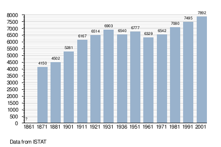
Demographic evolution

References
This article is issued from Wikipedia - version of the 2/15/2015. The text is available under the Creative Commons Attribution/Share Alike but additional terms may apply for the media files.
