Southeast Expressway (Massachusetts)
| |
|---|---|
|
Map of eastern Massachusetts with Southeast Expressway highlighted in red | |
| Route information | |
| Length: | 8.3 mi (13.4 km) |
| Major junctions | |
| South end: |
|
|
Furnace Brook Parkway in Quincy | |
| North end: |
|
| Location | |
| Counties: | Norfolk, Suffolk |
| Highway system | |


_Map.svg.png)
The Southeast Expressway is a limited-access road located between the Braintree Split and the Thomas P. O'Neill Jr. Tunnel in the suburbs of Boston, Massachusetts as well as the city itself. It carries Interstate 93, U.S. Route 1 and Massachusetts Route 3.
History
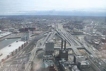
The Southeast Expressway was constructed between 1954 and 1959, at the same time the John F. Fitzgerald Expressway (Central Artery) was built. Its northern terminus is at Exit 18 (Massachusetts Avenue) in South Boston, a former Y-interchange where the cancelled Inner Belt (I-695) was to meet with the expressway and the Central Artery. The southern terminus is at the Y-interchange (the "Braintree Split") at Exit 7 in Braintree (where Route 128 "unofficially" begins).
A section of the Expressway, beginning south of the Savin Hill overpass and ending just before the Braintree Split interchange at the original southern terminus of Route 128 in Braintree, Massachusetts utilizes a zipper lane, in which a movable barrier carves out a reversible high occupancy vehicle lane on the non-peak side of the highway during rush hour.