U.S. Route 1 in Massachusetts
| |||||||
|---|---|---|---|---|---|---|---|
 | |||||||
| Route information | |||||||
| Maintained by MassDOT | |||||||
| Length: | 85.60 mi[1] (137.76 km) | ||||||
| Existed: | 1926 – present | ||||||
| Major junctions | |||||||
| South end: |
| ||||||
| North end: |
| ||||||
| Location | |||||||
| Counties: | Bristol, Norfolk, Suffolk, Middlesex, Essex | ||||||
| Highway system | |||||||
| |||||||

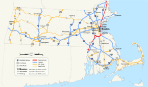
In the U.S. state of Massachusetts, U.S. Route 1 is a major north–south highway through Boston. The portion of US 1 south of Boston is also known as the Norfolk and Bristol Turnpike (more commonly known as Boston-Providence Turnpike), and portions north of the city are known as the Northeast Expressway and the Newburyport Turnpike.
Route description
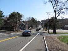
US 1 enters the state from Rhode Island at Attleboro. It closely parallels Interstate 95 as it goes through the towns of North Attleborough, Plainville, Wrentham, Foxborough(where Gillette Stadium is), Walpole, Sharon, Norwood (where a segment is known as the Norwood Automile due to the many car dealerships that line the road), and Westwood. US 1 then has a wrong-way concurrency with Interstate 95 up to the junction with Interstate 93 then travels along with Interstate 93 from Canton through downtown Boston. The two highways separate just after passing through the Thomas P. O'Neill Jr. Tunnel and crossing the Leonard P. Zakim Bunker Hill Memorial Bridge. The route crosses the Tobin Bridge traveling over Chelsea and Revere as a freeway known as Boston's Northeast Expressway, then as a four to six lane RIRO expressway (surface road without at-grade intersections or traffic lights) through Malden, Saugus and Lynnfield. From Lynnfield, US 1 again closely parallels Interstate 95 going through the towns of Peabody, Danvers, Topsfield, Ipswich, Rowley, Newbury, Newburyport, and Salisbury, before it enters the state of New Hampshire.
Route 1A runs alongside Route 1 in four parts of the state.
History
Route 1 in Massachusetts was constructed in sections throughout the 1930s, partly by widening existing roads and also by constructing new right of ways to bypass more congested areas. Originally most of the highway was two or three lanes in each direction, with numerous widening and improvements made over the years.
Turnpike era
Most of US 1 consists of two former turnpike roads — the Norfolk and Bristol Turnpike and the Newburyport Turnpike. The older roads that these turnpikes were meant to bypass are now mostly Route 1A.
Massachusetts Route C1

In the early 1930s, Route C1 was designated as an alternate route of US 1 through downtown Boston. The "C" indicated a city route. The C designation was apparently distinct to the Boston area. Route C1 ran along Brookline Avenue, Beacon Street, Embankment Road (modern Route 28), Charles Street, Lowell Street, Merrimac Street, and Cross Street to the west end of the Sumner Tunnel. In East Boston, it went via Porter Street to Chelsea Street then shifted to the William McClellan Highway (modern Route 1A). As Storrow Drive and the Central Artery opened in the 1950s, Route C1 was rerouted to follow portions of these highways. The Route C1 designation was removed in 1971, with US 1 taking over most of the alignment south of the Charles River, and Route 1A taking over most of the alignment north of the river. US 1 was later moved onto the Southeast Expressway leaving most of the former alignment of C1 south of the river as having no number.
Relocation in Boston
US 1 replaced the cancelled I-95 on the Northeast Expressway, north of downtown Boston, in the 1970s.[2] In the late 1980s, at the request of the Metropolitan District Commission (now the DCR) in an attempt to reduce the incidence of overheight vehicles finding their way onto Storrow Drive [3] US 1 was moved onto I-93 south of and through Boston, leaving the old route - VFW Parkway, Jamaicaway, Riverway, and Storrow Drive through Dedham, Brookline, West Roxbury and several other Boston neighborhoods - without a number. There are still some street signs incorrectly indicating the former alignment as US 1, and many local residents still refer to parts of VFW Parkway and Jamaicaway as "Route 1", as if it still runs along its old trajectory.
Major intersections
| County | Location | mi | km | Destinations | Notes | ||
|---|---|---|---|---|---|---|---|
| Bristol | Attleboro | 0.0 | 0.0 | Continuation into Rhode Island | |||
| 0.3 | 0.48 | Northbound exit and southbound entrance, exit 1 on I-95 | |||||
| 1.8 | 2.9 | ||||||
| 2.0 | 3.2 | North end of Route 1A (Bristol County section) | |||||
| North Attleborough | 4.0 | 6.4 | Exits 1A-B on I-295 | ||||
| 5.2 | 8.4 | Eastern end of Route 120 | |||||
| 7.4 | 11.9 | South end of Route 1A (Norfolk County section) | |||||
| Norfolk | Plainville | 8.4 | 13.5 | ||||
| 10.0 | 16.1 | Northern end of Route 152 | |||||
| 10.6 | 17.1 | Exits 14A-B on I-495 | |||||
| Foxborough | 13.6 | 21.9 | Connection via local roads | ||||
| Sharon | 19.2 | 30.9 | exit 9 on I-95 | ||||
| 20.6 | 33.2 | Southbound exit and northbound entrance | |||||
| Walpole | 21.2 | 34.1 | South end of freeway | ||||
| Westwood | 25.9 | 41.7 | |||||
| Dedham | 25.9 | 41.7 | South end of overlap with I-95 / Route 128, exit 15 on I-95 / Route 128 South end of limited-access highway | ||||
| See Route 128 exits 15-12 and I-93 exits 1-26 | |||||||
| Suffolk | Boston | 46.5 | 74.8 | North end of overlap with I-93, exit 27 on I-93 | |||
| 47.1 | 75.8 | Via Route 99 | |||||
| Mystic River | Maurice J. Tobin Memorial Bridge | ||||||
| Suffolk | Chelsea | 48.4 | 77.9 | Beacon Street / Everett Avenue | Northbound exit to Beacon, southbound entrance from Everett | ||
| 49.0– 49.3 | 78.9– 79.3 | Fourth Street / Fifth Street | Northbound exit to Fourth and southbound entrance from Fifth | ||||
| 49.7 | 80.0 | Sixth Street | Northbound entrance only | ||||
| 49.9 | 80.3 | Carter Street – Chelsea, East Boston | Southbound exit and entrance; | ||||
| 50.1 | 80.6 | Southern terminus of Route 38; No Southbound entrance | |||||
| 50.3 | 81.0 | Webster Avenue – Chelsea, Everett | Northbound exit and Southbound entrance | ||||
| 50.5 | 81.3 | Northbound exit and entrance | |||||
| Revere | 50.8 | 81.8 | Southbound exit and entrance | ||||
| 51.8 | 83.4 | Sargent Street – West Revere | Northbound exit and southbound entrance | ||||
| 52.4– 52.8 | 84.3– 85.0 | Copeland Circle | |||||
| 53.1 | 85.5 | Lynn Street east – Saugus Lynn | |||||
| Middlesex | Malden | 53.3 | 85.8 | Lynn Street west – Malden Everett | |||
| Essex | Saugus | 54.5 | 87.7 | No northbound exit, northern end of Route 99 | |||
| 54.8 | 88.2 | Essex Street – Saugus, Melrose | |||||
| 55.3 | 89.0 | Main Street – Saugus, Wakefield | |||||
| 56.5 | 90.9 | Lynn Fells Parkway west – Melrose, Stoneham | East end of the Lynn Fells Parkway | ||||
| 57.8 | 93.0 | South end of overlap with Route 129 | |||||
| Lynnfield | 58.8 | 94.6 | North end of overlap with Route 129 | ||||
| Peabody | 59.5– 60.1 | 95.8– 96.7 | Exit 44 on I-95 / Route 128 | ||||
| 61.0 | 98.2 | Northbound exit and southbound entrance | |||||
| 61.6 | 99.1 | Lowell Street – Peabody | |||||
| Danvers | 62.5 | 100.6 | |||||
| 63.2 | 101.7 | Centre Street – Danvers | |||||
| 64.2 | 103.3 | ||||||
| 65.0 | 104.6 | Exit 50 on I-95; North end of freeway | |||||
| Topsfield | 68.1 | 109.6 | |||||
| Rowley | 73.1 | 117.6 | |||||
| Newburyport | 80.9 | 130.2 | Summer Street / Winter Street – Downtown Newburyport | Northbound exit (Summer) and southbound entrance (Winter) | |||
| 81.1 | 130.5 | North end of with Route 1A (Essex and Suffolk County sections), southbound exit and northbound entrance, north end of limited-access highway | |||||
| Salisbury | 83.0 | 133.6 | Eastern end of Route 110 | ||||
| 83.1 | 133.7 | South end of Route 1A (Essex and Rockingham County sections) | |||||
| 85.3 | 137.3 | ||||||
| 86.2 | 138.7 | Continuation into New Hampshire | |||||
1.000 mi = 1.609 km; 1.000 km = 0.621 mi
| |||||||
Widening project
The Massachusetts Department of Transportation was proposing a $137 million project to widen the existing 2.4-mile four-lane highway section to six lanes, from north of Route 99 in Saugus to south of Route 60 in Revere. The project consisted of adding a twelve-foot travel lane and ten-foot shoulder in each direction. Work also include reconstruction of the Copeland Circle interchange by eliminating the existing rotary, and demolition of the existing 1957 bridges from the never-built highway extension. The Lynn Street/Salem Street interchange in Malden, and the Route 99 interchange in Saugus, were slated to be reconstructed. Major rock blasting will be required for the project due to a massive ledge next to the highway. Seven bridges will be replaced and three others upgraded to handle the new lanes.
In 2012, $10 million was added to the state budget with the intent to be used for design costs and pulling permits for Route 1. [4] The project was expected to begin in 2012, but no further movement by the state has been implemented. Since then, town officials have made the push to ask the Massachusetts Department of Transportation to revisit the project and begin development. [5]
References
- ↑ itd. "Executive Office of Transportation - Office of Transportation Planning Roads". Administration and Finance. Retrieved 1 October 2014.
- ↑ "Northeast Expressway (US 1)". Bostonroads.com. Retrieved 2012-08-15.
- ↑ Personal Conservation 3-2016 with Steve Timmins, MassDOT Highway Signing Engineer
- ↑ "Revere, Malden, Saugus call for relief to Route 1 gridlock". Boston Globe. 2014-01-09. Retrieved 2015-01-05.
- ↑ "Joint Letter 12-10-13 Route 1 - Improvement MPO". Gary Christenson, Daniel Rizzo, Scott Crabtree. 2013-12-10. Retrieved 2015-01-05.
| Previous state: Rhode Island |
Massachusetts | Next state: New Hampshire |