Speen, Berkshire
| Speen | |
 St Mary the Virgin parish church |
|
.jpg) Maize fields and the Lambourn, Woodspeen, Speen |
|
 Speen |
|
| Area | 14.53 km2 (5.61 sq mi) |
|---|---|
| Population | 2,635 (2011 census)[1] |
| – density | 181/km2 (470/sq mi) |
| OS grid reference | SU4568 |
| Civil parish | Speen |
| Unitary authority | West Berkshire |
| Ceremonial county | Berkshire |
| Region | South East |
| Country | England |
| Sovereign state | United Kingdom |
| Post town | Newbury |
| Postcode district | RG14 |
| Dialling code | 01635 |
| Police | Thames Valley |
| Fire | Royal Berkshire |
| Ambulance | South Central |
| EU Parliament | South East England |
| UK Parliament | Newbury |
Coordinates: 51°24′35″N 1°20′30″W / 51.40976°N 1.34165°W
Speen is a village and civil parish in West Berkshire, England. Centred 2 miles (3 km) north west of the largest town in the district, Newbury, Speen has clustered settlements, the largest of which is Speen village (which is contiguous with Newbury) and the others are buffered from the town by the A34 road and named Bagnor, Stockcross, Woodspeen and Marsh Benham.
Its other land is an approximately even mixture of woodland and agricultural fields (including cultivated crops, hay meadow for livestock feed and pasture) and varies greatly in elevation, having the Reading to Taunton Line alongside the north bank of the River Kennet as its southern boundary and both banks of the Lambourn in its north with elevated ground in between.
Benham Park in the south-west of the area is a listed landscape garden and house under the national statutory scheme.
History
Speen has the frequently broken-up footpath marking the Ermin Street/Ermin Way, the main Roman road from Corinium Dobunnorum (Cirencester, Gloucestershire) to Calleva Atrebatum (Silchester, Hampshire).
The English Civil War Second Battle of Newbury was fought at Speen on 27 October 1644. Speenhamland in the parish, now part of Newbury, was the eponymous home of the Speenhamland system of outdoor (poor) relief.[2]
Landmarks
Parish church
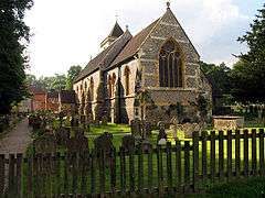
The Church of England parish church of Saint Mary the Virgin is late Saxon and is the oldest church in Berkshire.[3] It is the burial place of Giovanni Battista Castiglione (1515–97), Queen Elizabeth I's Italian tutor and servant, who was given nearby (in the parish) Benham Valence house and park in 1570.[4]
The Ladywell or lady well
The church, as stated to Our Lady (an alternative name for the Virgin Mary, generally deprecated from the reign of Elizabeth I among Anglicans) was built near one of the holy wells of Christendom, which is as with many wells, an enlarged spring. Tenuous local tradition says its water is able to cure eye diseases and other ills, and there have been reports it is haunted. Some of the village people have seen an old woman with white hair and wearing a blue rain mac wandering around the grave yard and up the path the well is situated on. The Ladywell was fenced off in the Victorian era.[5]
Speen House
Next to the above sites are ramparts around elevated Speen House, the latest incarnation of Speen manor house, which is mostly late 18th century, but incorporates a minority of building materials from its 17th century precursor. Early historians have dated a few stones among the foundations to the Roman village of Spinae, but it is more likely that these oldest stones were sourced and hewn for the late medieval manor house, nothing else of which survives.[6]
Benham Park
Benham Park or Benham Valence Manor is a landscape garden centred on its house (also officially, currently known as Benham Park) built by Henry Holland and Capability Brown for William, 6th Baron Craven in 1775. It was later the home of his widow, Elizabeth, and her second husband, the Margrave of Anspach. The building is Grade II* listed (the mid category) and park is Grade II listed (the initial category),[7] One of its pairs of grand and ornate gate piers (pilasters) is separately Grade I listed.[8][9]
Demography
| Output area | Homes owned outright | Owned with a loan | Socially rented | Privately rented | Other | km² roads | km² water | km² domestic gardens | Usual residents | km² |
|---|---|---|---|---|---|---|---|---|---|---|
| Civil parish | 378 | 338 | 168 | 173 | 28 | 0.340 | 0.350 | 0.623 | 2635 | 14.53 |
Geography
.jpg)
Speen has clustered settlements, the largest of which is Speen village (which is contiguous with Newbury) and the others are buffered from the town by the A34 road and named Bagnor, Stockcross, Woodspeen and Marsh Benham.
Its other land is an approximately even mixture of woodland and agricultural fields (including cultivated crops, hay meadow for livestock feed and pasture) and varies greatly in elevation, having the Reading to Taunton Line alongside the north bank of the River Kennet as its southern boundary and both banks of the Lambourn in its north with elevated ground in between.
Transport
- Buses
- Rail
Speen railway station served the parish until it was closed in 1960. The nearest railway station now is Newbury which is connected by bus.
- Roads
A trunk route dual carriageway cuts through the middle of the parish in a roughly straight line north-south: the A34 road it has the nucleus of the village to its east closest to one of the three Newbury junctions and the roads proceeds to a full (i.e. grade-separated) intersection with the M4 corridor at Chieveley, Berkshire before passing Didcot and Oxford.
References
- 1 2 Key Statistics: Dwellings; Quick Statistics: Population Density; Physical Environment: Land Use Survey 2005
- ↑ Page, William; Ditchfield, P.H., eds. (1924). "Speen with Speenhamland, Bagnor and Benham". A History of the County of Berkshire. Victoria County History. 4. pp. 97–110.
- ↑ "St Mary's Church, Speen, Newbury". St-mary-speen.org. Retrieved 21 February 2013.
- ↑ "Speen". Speenpc.org.uk. Retrieved 2013-02-21.
- ↑ Living springs sites The University of Bath. Retrieved 2014-12-12.
- ↑ Historic England. "Details from listed building database (1220635)". National Heritage List for England. Speen House - Grade II listing entry.
- ↑ Historic England. "Benham Park, Bath Road (Grade II*) (1220740)". National Heritage List for England. Retrieved 2 September 2014.
- ↑ National Monuments Record
- ↑ Historic England. "Gate piers and gates at Benham Park, West Lodge (Grade I) (1220645)". National Heritage List for England. Retrieved 2 September 2014.
- ↑ Heyfordian Travel Route 4 timetable
- ↑ Go-Ride Routes 5 & 5A timetable
External links
| Wikimedia Commons has media related to Speen, Berkshire. |