Spencer Township, DeKalb County, Indiana
| Spencer Township | |
|---|---|
| Township | |
|
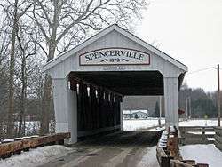
West portal of the Spencerville, Indiana covered bridge. | |
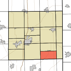 Location of Spencer Township in DeKalb County | |
| Coordinates: 41°17′32″N 84°54′16″W / 41.29222°N 84.90444°WCoordinates: 41°17′32″N 84°54′16″W / 41.29222°N 84.90444°W | |
| Country | United States |
| State | Indiana |
| County | DeKalb |
| Government | |
| • Type | Indiana township |
| Area | |
| • Total | 18.01 sq mi (46.6 km2) |
| • Land | 17.95 sq mi (46.5 km2) |
| • Water | 0.07 sq mi (0.2 km2) |
| Elevation[1] | 797 ft (243 m) |
| Population (2010) | |
| • Total | 1,233 |
| • Density | 68.7/sq mi (26.5/km2) |
| FIPS code | 18-71918[2] |
| GNIS feature ID | 453859 |
Spencer Township is one of fifteen townships in DeKalb County, Indiana. As of the 2010 census, its population was 1,233 and it contained 452 housing units.[3]
History
The Spencerville Covered Bridge was added to the National Register of Historic Places in 1981.[4]
Geography
According to the 2010 census, the township has a total area of 18.01 square miles (46.6 km2), of which 17.95 square miles (46.5 km2) (or 99.67%) is land and 0.07 square miles (0.18 km2) (or 0.39%) is water.[3]
Unincorporated towns
Adjacent townships
- Concord Township (north)
- Newville Township (east)
- Scipio Township, Allen County (southeast)
- Springfield Township, Allen County (south)
- Cedar Creek Township, Allen County (southwest)
- Jackson Township (west)
Major highways
Cemeteries
The township contains two cemeteries: Riverside and White City.
References
- ↑ "US Board on Geographic Names". United States Geological Survey. 2007-10-25. Retrieved 2008-01-31.
- ↑ "American FactFinder". United States Census Bureau. Retrieved 2008-01-31.
- 1 2 "Population, Housing Units, Area, and Density: 2010 - County -- County Subdivision and Place -- 2010 Census Summary File 1". United States Census. Retrieved 2013-05-10.
- ↑ National Park Service (2010-07-09). "National Register Information System". National Register of Historic Places. National Park Service.
External links
Municipalities and communities of DeKalb County, Indiana, United States | ||
|---|---|---|
| Cities | ||
| Towns | ||
| Townships | ||
| Unincorporated communities | ||
| Footnotes | ‡This populated place also has portions in an adjacent county or counties | |
This article is issued from Wikipedia - version of the 9/7/2015. The text is available under the Creative Commons Attribution/Share Alike but additional terms may apply for the media files.