St. Augustine Town Plan Historic District
|
St Augustine Town Plan Historic District | |
|
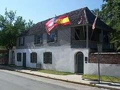
Gonzalez-Alvarez House, an NHL itself and contributing property to the district | |
 | |
| Location | Roughly bounded by Grove Ave, the Matanzas River, and South and Washington Sts., St. Augustine, Florida |
|---|---|
| Coordinates | 29°53′31″N 81°18′51″W / 29.89194°N 81.31417°WCoordinates: 29°53′31″N 81°18′51″W / 29.89194°N 81.31417°W |
| Area | 113 acres (0.46 km2)[1] |
| NRHP Reference # | 70000847[2] |
| Significant dates | |
| Added to NRHP | April 15, 1970[2] |
| Designated NHLD | April 15, 1970[3] |
| Wikimedia Commons has media related to St. Augustine Town Plan Historic District. |
The St Augustine Town Plan Historic District is a U.S. National Historic Landmark District (designated as such on April 15, 1970) located in St. Augustine, Florida. The district is bounded by Grove Ave, the Matanzas River, and South and Washington Streets. It contains 220 historic buildings, 1 structure and 1 object.
References
- ↑ ["St. Augustine Historic District", by Diana Primelles "National Register of Historic Places Inventory-Nomination"] Check
|url=value (help) (PDF). National Park Service. - 1 2 National Park Service (2010-07-09). "National Register Information System". National Register of Historic Places. National Park Service.
- ↑ St. Augustine Town Plan Historic District at National Historic Landmarks Program
External links
- "St. Augustine Town Plan Historic District". National Register of Historic Places Travel Itinerary. National Park Service.
- "Inventory of Buildings" (PDF). City of St. Augustine - Department of Heritage Tourism. 2008-10-17.

This article is issued from Wikipedia - version of the 11/26/2016. The text is available under the Creative Commons Attribution/Share Alike but additional terms may apply for the media files.