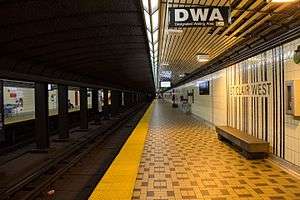
St. Clair West (TTC)
 | ||||||||||||||||
| Location |
370 St. Clair Avenue West Toronto, Ontario Canada | |||||||||||||||
| Coordinates | 43°41′02″N 79°24′54″W / 43.683888°N 79.415113°WCoordinates: 43°41′02″N 79°24′54″W / 43.683888°N 79.415113°W | |||||||||||||||
| Platforms | side platforms | |||||||||||||||
| Tracks | 2 | |||||||||||||||
| Connections |
| |||||||||||||||
| Construction | ||||||||||||||||
| Structure type | underground | |||||||||||||||
| Disabled access | No | |||||||||||||||
| Architect | TTC in house architects[1] | |||||||||||||||
| History | ||||||||||||||||
| Opened | 28 January 1978 | |||||||||||||||
| Traffic | ||||||||||||||||
| Passengers (2014[2]) | 29,480 | |||||||||||||||
| Services | ||||||||||||||||
| ||||||||||||||||
St. Clair West is a subway station on the Yonge–University line in Toronto, Ontario, Canada. It spans the block north of St. Clair Avenue West to Heath Street, between Bathurst Street and Tweedsmuir Avenue. The station serves the local communities of Forest Hill South, Humewood, Bracondale Hill and Casa Loma.
During weekday morning rush hours, half of all northbound trains on the Yonge–University line are short-turned here,[3] resulting in more frequent service south of the station. Although the station is not wheelchair-accessible, there is an elevator at the Heath Street exit. Work is underway to make the station wheelchair-accessible by 2016. This work will include three elevators to access street, bus and streetcar level, concourse, and northbound/southbound platforms, automatic sliding doors and an accessible fare gate.[4]
History
This station was opened in 1978, as part of the subway line extension from St. George Station to Wilson Station. Its south end was then in the City of Toronto while its north end was in the Borough of York.
The sports field of St. Michael's College School is directly above the length of the station and a Loblaws supermarket is located over the entrance on the north side of St. Clair Avenue.
The 1995 Russell Hill subway incident occurred on August 11, 1995, between this station and Dupont Station to the south on the southbound line. The impact site was closer to Dupont Station than to St. Clair West Station.
Architecture and art
St. Clair West, designed by the TTC's in-house architects,[5] is a colourful station featuring a wide variety of interior finishes such as ceramic tiles, brick and sculptural concrete surfaces. Backlit orange panels and an abstract tile pattern resembling a barcode at platform level distinguish the station from others in the system. The TTC built its first underground streetcar loop at this station circling an exceptionally spacious waiting area for connections to surface routes. Wilson is the one other station on the line which, due to its complexity, the TTC chose to design themselves.[5]
The abstract enamel mural Tempo by Gordon Rayner[6] is on the mezzanine-level bridge crossing the tracks. Buskers often take advantage of the acoustics caused by the station's open architecture.
Subway infrastructure in the vicinity
South of the station, the subway tunnel cuts southeast through the Nordheimer Ravine, where the emergency exit used in the Russell Hill accident is located,[7] then continues in a bored tunnel south beneath Spadina Road and under Casa Loma to Dupont Station.
Also constructed by cut-and-cover north of the station, the tunnel runs northwest through the Cedarvale Ravine to Eglinton West Station.
Surface connections
These routes[8] can be boarded in the underground loop:
- 33 Forest Hill via Spadina Road to Eglinton Avenue
- 90A Vaughan to Oakwood Avenue
- 90B to Eglinton Avenue
- 126 Christie to Christie Station
- 512 St. Clair streetcar eastbound to St. Clair subway station (Yonge Street); westbound to Gunns Loop (west of Keele Street)
- 312 Blue Night St. Clair West eastbound to St. Clair subway station and westbound to Jane subway station. Overnight service stops on St. Clair Avenue and does not enter the station
To connect to this bus route passengers can walk outside the station to Bathurst Street and use a valid paper transfer.[9]
- 7 Bathurst between Bathurst Station and Steeles Avenue
References
- ↑ http://archindont.torontopubliclibrary.ca/ArchindontWeb/buildingType.do?type=Subway+Stations&typeID=112
- ↑ "Subway ridership, 2014" (PDF). Toronto Transit Commission. Retrieved September 12, 2015.
This table shows the typical number of customer-trips made on each subway on an average weekday and the typical number of customers travelling to and from each station platform on an average weekday.
- ↑ Kane, Laura (2014-03-31). "Big Ideas: Bring back Bay Lower Station to relieve Yonge-University line". Toronto Star.
- ↑ "St. Clair West Station Easier Access Project" (PDF). TTC. June 25, 2013. Retrieved November 2014. Check date values in:
|access-date=(help) - 1 2 Robert Moffatt (28 October 2010). "Art and architecture on the Yonge–University subway". Toronto Modern. Retrieved August 2012. Check date values in:
|access-date=(help) - ↑ "Gordon Rayner". Centre for Contemporary Canadian Art. Retrieved August 2012. Check date values in:
|access-date=(help) - ↑ Lost River Walks: Nordheimer Reach
- ↑ St Clair West Station: Connections to
- ↑ TTC: Walking Transfers
External links
![]() Media related to St. Clair West Station at Wikimedia Commons
Media related to St. Clair West Station at Wikimedia Commons