St Ann's, London
| St Ann's | |
 St Ann's |
|
| Population | 14,638 (2011 Census. Ward)[1] |
|---|---|
| OS grid reference | TQ314872 |
| London borough | Haringey |
| Ceremonial county | Greater London |
| Region | London |
| Country | England |
| Sovereign state | United Kingdom |
| Post town | LONDON |
| Postcode district | N15 |
| Dialling code | 020 |
| Police | Metropolitan |
| Fire | London |
| Ambulance | London |
| EU Parliament | London |
| UK Parliament | Tottenham |
| London Assembly | Enfield and Haringey |
Coordinates: 51°34′53″N 0°05′07″W / 51.5813°N 0.0852°W
St Ann's is a neighbourhood in England, in the south of the London Borough of Haringey to the east of Harringay and West Green. It is located within, but is distinct from, St Ann's ward.
Location
St Ann's extends from Chestnuts Park in the west to Seven Sisters Road in the east. To the south, its boundary is defined by the London Overground railway line.
History
St. Ann's Church was built in a rural setting in the middle of the nineteenth century and consecrated in 1861. A hamlet soon began to grow up around the church. However, it was quickly swallowed up by the northward march of London. By the mid-1890s, it could no longer be distinguished as a separate hamlet.[2]
Education
- For details of education in St Ann's, see the London Borough of Haringey article.
Nearest places
Transport
Nearest tube and rail stations
- Seven Sisters tube and railway station
- South Tottenham railway station
- Stamford Hill railway station
- Harringay Green Lanes railway station
References
- ↑ "Haringey Ward population 2011". Neighbourhood Statistics. Office foe National Statistics. Retrieved 23 October 2016.
- ↑ 'Tottenham: Growth after 1850', A History of the County of Middlesex: Volume 5: Hendon, Kingsbury, Great Stanmore, Little Stanmore, Edmonton Enfield, Monken Hadley, South Mimms, Tottenham (1976), pp. 317-324. URL: http://www.british-history.ac.uk/report.aspx?compid=26986&strquery=ann's
| Districts | 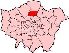 | |
|---|---|---|
| Attractions | ||
| Parks and open spaces |
| |
| Constituencies | ||
| Tube and railway stations | ||
| Other topics | ||
This article is issued from Wikipedia - version of the 10/23/2016. The text is available under the Creative Commons Attribution/Share Alike but additional terms may apply for the media files.