St Leonards, New South Wales
| St Leonards Sydney, New South Wales | |||||||||||||
|---|---|---|---|---|---|---|---|---|---|---|---|---|---|
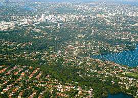 Aerial view of Longueville, Riverview, St Leonards | |||||||||||||
| Population | 4,467 (2011 census)[1] | ||||||||||||
| • Density | 3,873.68/km2 (10,032.8/sq mi) | ||||||||||||
| Established | 1853 | ||||||||||||
| Postcode(s) | 2065 | ||||||||||||
| Area | 0.8 km2 (0.3 sq mi) | ||||||||||||
| Location | 5 km (3 mi) north of Sydney CBD | ||||||||||||
| LGA(s) | Municipality of Lane Cove, North Sydney Council, City of Willoughby | ||||||||||||
| State electorate(s) | Lane Cove, North Shore, Willoughby | ||||||||||||
| Federal Division(s) | North Sydney | ||||||||||||
| |||||||||||||
St Leonards is a suburb on the lower North Shore of Sydney, in the state of New South Wales, Australia. St Leonards is located 5 km north-west of the Sydney central business district and lies across the local government areas of Municipality of Lane Cove, North Sydney Council and the City of Willoughby.
History
St Leonards was named after English statesman Thomas Townshend, 1st Viscount Sydney of St Leonards. Originally, St Leonards applied to the whole area from the present suburb of North Sydney to Gore Hill. The township of St Leonards in 1883 is now North Sydney.
The oldest railway station on the North Shore line opened in 1890 in St Leonards and originally only ran to Hornsby.[2]
The Gore Hill cemetery was established on the Pacific Highway in 1868 and was the main burial site for the area until its closure in 1975. It is still maintained as a heritage site by the Department of Local Government and Lands, Willoughby Municipal Council and the Heritage Council of New South Wales.
Commercial area
St Leonards has a commercial centre that complements the role of Chatswood, Lane Cove and North Sydney as one of the centres for business on the North Shore of Sydney. St Leonards contains one of Sydney's suburban skyscraper clusters, with major offices for many large companies including Toyota Financial Services, IBM, Lenovo, Oporto Chicken & Burgers, Manchester Unity, 3, Savvytel, CIMIC Group, Forum Group, Macquarie Media Group and Channel 31 TV Studio . The NSW Department of Education and Training host their Information Technology Directorate in Herbert Street. Gore Hill Technology Park is the site of current Fox Sports television studios.
The Forum
The Forum is built over the railway station and comprises three commercial office buildings, two residential towers containing 782 apartments, a Coles Central mini-supermarket, and 34 food and retail shops.[3]
The suburb's tallest building is the Forum Tower (38 stories/118 m), with 483 apartments including many with panoramic views of the city skyline. Forum West is the second of the two residential buildings within the Forum Plaza, standing 25 stories tall with 290 apartments. Forum Tower was completed in August 1999 and Forum West 3 years later. Both buildings boast a concierge, pool, spa, gym and private & public car parking facilities each. Winten Property Group was responsible for the construction of both buildings, and continues to build apartment buildings in St Leonards with the construction of the T1 Apartments in Atchison St in 2012.
The Plaza also contains offices for Cisco Systems, Verizon Business, Getty Images and Carnival Cruise Lines, among other companies.
Transport
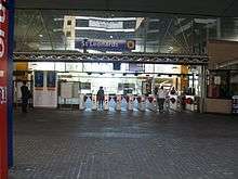
St Leonards railway station is on the North Shore, Northern & Western Line of the Sydney Trains network. The Pacific Highway is the major road through the suburb.
Health
A major landuse in the suburb is the Royal North Shore Hospital which is the largest hospital north of Port Jackson (Sydney Harbour) in Sydney.
Schools and churches
- A campus of the University of Technology, Sydney
- The campus of Northern Sydney TAFE
- Northside Community Church
- Royal North Shore Hospital Chapel[4]
Sport and recreation
St Leonards has developed into somewhat of a home for Rugby Union with the headquarters of the Australian Rugby Union relocated to St Leonards in 2007, from neighbouring North Sydney. The Northern Suburbs Rugby Club has its clubhouse in St. Leonards, featuring the Cabana Bar and Lounge.
Gore Hill Oval is the home ground of Australian Rules football club, North Shore Bombers.
Gallery
-
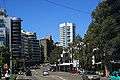
The Pacific Highway, St Leonards looking south
-

Apartments in St Leonards
-

Gore Hill Memorial Cemetery
-

Gore Hill Memorial Cemetery
-

The Forum
References
- ↑ Australian Bureau of Statistics (31 October 2012). "St Leonards (State Suburb)". 2011 Census QuickStats. Retrieved 5 November 2012.
- ↑ The Book of Sydney Suburbs, Compiled by Frances Pollen, Angus & Robertson Publishers, 1990, ISBN 0-207-14495-8, p.237
- ↑ Forum, St Leonards - Winten Property Group
- ↑ Chaplains 'pressured' over Royal North Shore crosses, Mosman Daily, 28 April 2009.
External links
| Wikimedia Commons has media related to St Leonards, New South Wales. |
- Willoughby City Council
- Naremburn/St Leonards - community profile
Coordinates: 33°49′34″S 151°11′25″E / 33.82613°S 151.19041°E