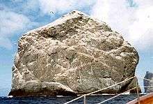
Stac Lee
| Meaning of name | "ly": shelter |
|---|---|
| Location | |
 Stac Lee Stac Lee shown within the Outer Hebrides | |
| OS grid reference | NA142049 |
| Physical geography | |
| Island group | St Kilda |
| Area | 2.3 ha (6 acres) |
| Highest elevation | 172 m (564 ft) |
| Administration | |
| Sovereign state | United Kingdom |
| Country | Scotland |
| Council area | Outer Hebrides |
| Demographics | |
| Population | 0 |
| References | [1][2][3] |
Stac Lee (Scottish Gaelic: Stac Lì) is a sea stack in the St Kilda group, Scotland. An island Marilyn (a point with topographic prominence of at least 150m), it is home to part of the world's largest colony of northern gannet.
Geography and geology

Martin Martin called the island "Stac-Ly";[2] other sources call it "Stac Lii."[4]
Stac Lee is located in the North Atlantic and forms part of the St Kilda archipelago of the Outer Hebrides. Lying in the north east of the St Kilda group, Stac Lee is around 7 km (4 mi) north east of Hirta, the main island, and 550 m (600 yards) west of the west cape of the island of Boreray.
Administratively, Stac Lee is part of the Na h-Eileanan Siar.
Topography

Stac Lee is a precipitous sea stack, i.e. a detached escarpment, 172 metres (564 ft) high.[3] Other sources give an altitude of 165 metres (541 ft),[5] or 220 metres (722 ft) above the sea bed. Having a prominence greater than 150 metres (492 ft), it is a Marilyn; its summit was reached by six, including Marilyn baggers and supporting rock climbers, on 13 October 2014.[6] There were more ascents in October 2015.[7]
Along with his sister Evelyn, Norman Heathcote climbed the stack in 1899 and wrote about it in his book St Kilda and in a climbing journal. He said that it was "comparatively easy" to climb although getting ashore onto the stack was "a most appalling undertaking" involving jumping ashore and climbing an overhanging cliff covered in slippery seaweed to a stanchion 20 feet (6.1 m) above sea level.[8]
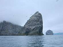
The nearby Stac an Armin reaches 196 metres (643 ft), making these the highest sea stacks in Britain.[5][9] Seen from the south, the rock appears as an imposing cliff as broad as high, while from the west it has the aspect of a thin needle with a top bevelled at an angle of 45°. The most impressive view is that obtained from the south-east, from where Stac Lee looks like a giant hook.
Wildlife
St Kilda has the world's largest colony of northern gannet, with an estimated 60,000 breeding pairs on Boreray, Stac an Armin and Stac Lee.[10] In 2004 about 14,000 occupied nest sites were observed on Stac Lee alone and this number is thought to have been stable over the previous ten years.[11]
A small bothy on Stac Lee was formerly used by St Kildan fowlers. It is big enough to accommodate two people and is dry inside. The St Kildans would land here by lassoing an iron peg, and then jumping when the swell rose up.
See also
Gallery
 Stac Lee (right) and Boreray
 Stac an Àrmainn with Boreray to the left and Stac Lee beyond at right
 Stac Lee from the south east
Footnotes
| Wikimedia Commons has media related to Stac Lee. |
- ↑ 2001 UK Census per List of islands of Scotland.
- 1 2 Haswell-Smith, Hamish (2004). The Scottish Islands. Edinburgh: Canongate. ISBN 978-1-84195-454-7.
- 1 2 Ordnance Survey.
- ↑ Heathcote, Norman (May 1901). "Climbing in St Kilda". Scottish Mountaineering Club Journal. 6 (5): 147–151. Retrieved 30 May 2014.
- 1 2 "St Kilda: Fascinating Facts". National Trust for Scotland. Retrieved 6 January 2007.
- ↑ BBC News
- ↑
- ↑ Heathcote, Norman (1900). St Kilda. London & New York: Longmans, Green & Co.
Heathcote, Norman. "Climbing in St Kilda". Scottish Mountaineering Club Journal. 6 (5): 147–152. Retrieved 1 June 2014. - ↑ Heights from Haswell-Smith (2004); National Trust website states 191 metres & 165 metres respectively.
- ↑ "Gannet - The bird with a crash helmet". National Trust for Scotland. Retrieved 7 June 2009.
- ↑ Murray, S; Wanless, S; Harris, MP (June 2006). "The status of the northern Gannet in Scotland in 2003-04" (PDF). British Birds. 26: 17–29. Retrieved 30 May 2014.
Coordinates: 57°52′03″N 8°30′06″W / 57.86750°N 8.50167°W