Stanground, Peterborough

Stanground is a residential area of the city of Peterborough, Cambridgeshire in the United Kingdom. For electoral purposes it comprises Stanground Central and Stanground East wards in North West Cambridgeshire constituency. Cambridgeshire Fire and Rescue Service maintain a fire station, crewed day and night and equipped with Water Tender and Incident Response Unit, off Whittlesey Road.[1]
Overview
Situated south of the River Nene, on relatively high ground overlooking The Fens, the area was historically part of the Isle of Ely in Cambridgeshire and of Huntingdonshire, rather than the Soke of Peterborough in Northamptonshire.[2] By 1901 Stanground was the only civil parish in England contained partly in two administrative counties.[3] In 1905 the part in the county of Huntingdon was created a separate parish, Stanground South, within Old Fletton Urban District and the anomaly removed; the remainder, in Thorney Rural District, becoming Stanground North.[4] In 1965 Huntingdonshire and the Soke amalgamated as Huntingdon and Peterborough and the Isle of Ely and historic Cambridgeshire (excluding Thorney Rural District which transferred to Huntingdon and Peterborough) amalgamated as Cambridgeshire and the Isle of Ely.[5] In 1974 Thorney Rural District and Old Fletton Urban District became part of the current district in the new non-metropolitan county.[6] As part of a Rural District prior to the passing of the Act, Stanground North remained parished.[7] This redundant parish which contained no dwellings or residents was finally abolished in 2003.[8]
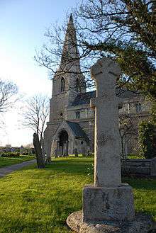
The ecclesiastical parish of Stanground is in the Diocese of Ely and covers the whole area. Because it also falls within the City of Peterborough, in addition to the oversight of the Bishop of Ely, the Bishop of Peterborough, acting as Assistant Bishop in the Diocese of Ely shares the pastoral oversight. [9][10] Lampass Cross, a 12th-century scheduled monument, stands in the churchyard.[11] The parish, along with its church, appears as Stoneground in the ghost stories of E. G. Swain, who was vicar there from 1905–1916. Situated adjacent to the fire station, Stanground cemetery, which opened in 1890, has limited grave availability for those residents who have family already buried there.[12]
Stanground St. Johns Church of England (Voluntary Controlled) Primary School, Oakdale County Primary School and Southfields County Infant and Junior schools are located in the area; secondary pupils attend Stanground Academy. The Italian honorary consular agency for Peterborough is based at the academy.[13]
See also
References
- ↑ Stanground Fire Station Cambridgeshire Fire and Rescue Service (retrieved 25 January 2009)
- ↑ Information about Stanground circa 1900 Kelly's Directory of Hunts. and Northamptonshire (p.60) Kelly & Co., London, 1903
- ↑ Areas for which populations have been given in the census reports 6.2 Modern Administrative Areas A vision of Britain through time Great Britain Historical GIS Project, University of Portsmouth, Department of Geography (retrieved 23 January 2008)
- ↑ Local Government Board Order No. 56410, made under the Local Government Act 1894 (56 & 57 Vict. c.73) s.36
- ↑ The Huntingdon and Peterborough Order 1964 (SI 1964/367), see Local Government Commission for England (1958 - 1967), Report and Proposals for the East Midlands General Review Area (Report No.3), 31 July 1961 and Report and Proposals for the Lincolnshire and East Anglia General Review Area (Report No.9), 7 May 1965
- ↑ The English Non-metropolitan Districts (Definition) Order 1972 (SI 1972/2039) Part 5: County of Cambridgeshire
- ↑ Local Government Act 1972 (1972 cap.70) s1(6)
- ↑ The Peterborough (Parishes) Order 2004 (SI 2004/995), see Bulletin of Changes to Local Authority Areas and Names in England Orders made between 1 April 2003 and 31 March 2004, Office of the Deputy Prime Minister, October 2004. See also Beasley, Gillian A Review of the Parishing Arrangements of the Peterborough City Council Area Draft Recommendations for Change, Peterborough City Council, 16 April 2003
- ↑ RELIGION: Bishops bridge boundaries aboard boat Peterborough Evening Telegraph, 2 August 2004
- ↑ Bridging the divide in a city Diocese of Ely, Ref. 0471, 29 July 2004
- ↑ Lampass Cross Hidden Heritage (retrieved 19 December 2009)
- ↑ Peterborough cemeteries Peterborough City Council (retrieved 11 December 2012)
- ↑ Consular Network Consulate General of Italy in London, 1 July 2008
External links
- Stanground College now Stanground Academy
- Stanground St. Johns School
- Oakdale School
- Southfields School
- Believe in Stanground!
- Park Farm Neighbourhood News
- Architecture in Peterborough
- Vice Consulate of Italy in Bedford
Coordinates: 52°33′11″N 0°13′05″W / 52.55306°N 0.21806°W