Stanpit

Coordinates: 50°43′N 1°46′W / 50.72°N 1.76°W
Stanpit is a historic village in the borough of Christchurch, Dorset, in southern England. It is located along the southern boundary of current day Mudeford. The Stanpit road connects from the end of the original Mudeford road through to Purewell Cross.
The village is mentioned in the Domesday Book (1086) as Stanpeta meaning 2 estates with meadows.[1] On Isaac Taylor's 1759 map of Hampshire it is marked as Stampit.[2]
Stanpit Marsh
Along part of the south west side of Stanpit road is Stanpit Marsh. It was formed as the result of action and deposition of material from the rivers Stour and Avon as they meet with the salt water within Christchurch Harbour. The site is owned by Christchurch Borough Council and managed by Christchurch Countryside Service. The area known as Stanpit Marsh is a mixture of habitats including areas of salt marsh, reed beds, freshwater marsh, gravel estuarine banks and sandy scrub.[3] Together with Grimbury Marsh, it forms one of the largest areas of salt marsh in the county.[4] The highest point of the marsh is an ancient grass covered sand dune named Crouch Hill. It stands 5 metres above sea level. To the east of Crouch hill lies Blackberry Point. In the past this was a small island within the Harbour known locally as Horseshoe Island. Today it has become firmly attached to the marsh.[4]
Stanpit Marsh is a Site of Special Scientific Interest (SSSI) and an important nature reserve of about 65 hectares (160 acres), combining both freshwater and saltwater habitats. There are over 300 species of plants growing there and 14 of them are considered to be nationally rare and endangered. [3] It is used by 312 species of bird, a few of which breed there. Many others are migratory and use the marsh as an important staging point. In 2001 a successful breeding program for Natterjack Toads was established.[3]
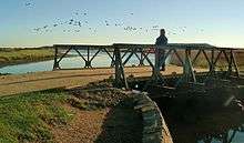
A circular path on the marsh uses a prototype Bailey Bridge to cross Mother Siller's Channel.[5] The Mother Siller's Channel is named after an 18th-century smuggler, Ma (Hannah) Seller, one time landlady of the Ship in Distress. This channel, now silted up, used to lead to the back of her pub and thus was a convenient 'trade' route.[6]
Formation and development
The marsh is geologically relatively new, the oldest parts date back about 10,000 years. Ever since the formation of the harbour, when the lower valleys of the rivers Avon and Stour were flooded by a post-glacial rise in sea level; the two rivers have been depositing their sediment in the shallow waters. During periods of low tide, channels and creeks began to appear and the isolated banks of silt became colonised by plants such as Glassworts, Sea Purslane and Seablite all of which have a high tolerance to salt water. These plants caused the flow of water to decrease further and thus more sediment was deposited. Eventually the mud banks grew above the high tide level and other vegetation was able to develop.[4]
The marsh is continuing to change and evolve. Separated from the older Stanpit Marsh by the Mother Siller's Channel is the more recent Grimbury marsh and to the south-east, the even more recent addition of Blackberry Island. Parts of the marsh have been drained and now provide grazing land for ponies.
The Marsh has a history of human activity dating back to 5000 BCE. Excavations in 1969 on the eastern bank of Mother Siller's Channel revealed finds left by Mesolithic nomadic people (3000 BCE). As well as flint fragments, traces of Purbeck Limestone and Portland stone were discovered showing evidence of human movements across Dorset. There have been considerable rises in the sea level over during the marshes existence. Finds up to the early Bronze Age were also made during these excavations. After the Iron Age material evidence of human activities is rare.[1]
The area was designated as a Local Nature Reserve in 1964 and a Site of Special Scientific Interest in 1986.
The Ship in Distress public house
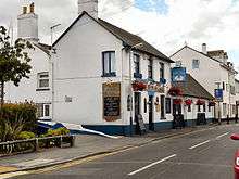
The Ship in Distress public house is located at the top of Mothers Sillars Channel, along the Stanpit road. It was the landlady of the pub, Hannah Seller, who the channel is named after. She had been married to the landlord of the Haven House on Mudeford Quay, and on his death, she took over the inn, later moving to The Ship in Distress. It appears that she was deeply involved in the free-trade: she allowed both pubs to be used for storage, and would induce customers to assist smuggling vessels in difficulties.[7]
The Ship in Distress was actively involved in the Battle of Mudeford, a skirmish fought between smugglers and Customs and Excise officers, which occurred in 1784.[7]
Next door to the pub was a tobacco and snuff factory, owned by the by then 'respectable' John Streeter who had earlier been gaoled for his part in the battle. Perhaps not unsurprisingly, many of the deliveries came at night and other local tobacco traders complained that they were unable to compete with Streeter.[6]
References
- 1 2 "Stanpit Marsh". Hengistbury-head.co.uk. Retrieved 7 May 2011.
- ↑ Section 22, Map of Hampshire (1759) Isaac Taylor
- 1 2 3 Dorset for You web page on Stanpit Marsh
- 1 2 3 Chaffey, John (2004). The Dorset Landscape, Its Scenery and Geology. Halsgrove House, Tiverton.: Dorset Books. p. 49. ISBN 1-871164-43-5.
- ↑ http://www.hengistbury-head.co.uk/stanpit.htm
- 1 2 Stannard, Michael (1999). The Makers of Christchurch: A Thousand Year story. Natula Publications. pp. 177–178. ISBN 978-1-897887-22-6.
- 1 2 Smuggling Gazetteer
| Wikimedia Commons has media related to Stanpit. |