Steeple Ashton
| Steeple Ashton | |
 The village, seen from across a field |
|
 Steeple Ashton |
|
| Population | 935 (in 2011)[1] |
|---|---|
| OS grid reference | ST907569 |
| Unitary authority | Wiltshire |
| Ceremonial county | Wiltshire |
| Region | South West |
| Country | England |
| Sovereign state | United Kingdom |
| Post town | TROWBRIDGE |
| Postcode district | BA14 |
| Dialling code | 01380 |
| Police | Wiltshire |
| Fire | Dorset and Wiltshire |
| Ambulance | South Western |
| EU Parliament | South West England |
| UK Parliament | South West Wiltshire |
| Website | Parish Council |
Coordinates: 51°18′40″N 2°08′06″W / 51.311°N 02.135°W
Steeple Ashton is a village and civil parish in Wiltshire, England, 3 miles (4.8 km) east of Trowbridge.
The parish includes the hamlet of Ashton Common.
Name and history
Until the Dissolution of the Monasteries, Steeple Ashton was a manor of Romsey Abbey. It was also part of the hundred of Whorwellsdown.
The first element of the village's name may represent a former steeple of the church. However the prefix "Staple" or "Steeple-" sometimes indicates the privilege of holding a market, with a stapol or pole being set up to advertise its location to all passing through.[2] Steeple Ashton was indeed once a market town, holding a weekly market, the market cross for which still stands on the village green.
A great fire destroyed the textile mills within the small town, and when it came to rebuilding they moved to the nearby town of Trowbridge, where the River Biss provided better power. The business of the market then moved to neighbouring towns such as Market Lavington.
In 1818 the parish extended north and west to include Great Hinton, Semington, and West Ashton.[3] In the late 19th century separate civil parishes were created for each of those three villages, greatly reducing the area of Steeple Ashton parish.
The parish had 955 inhabitants in 1991 but had had twice as many in 1981.[4] This is due to the parish boundary of Trowbridge being moved to include new housing estates which had been built at the edge of the town but within the parish of Steeple Ashton.
Churches
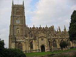
The Anglican Church of St Mary the Virgin dominates the village and is large enough to serve a medium-sized town.[5] It was built in the late 15th century and is Grade I listed.[6] The spire was struck by lightning and rebuilt in 1670, only to be struck by lightning a second time. It was not rebuilt again and the present day church has only a square tower. Some locals have it that a third spire was abandoned on the basis that the first two lightning strikes intimated divine disapproval.
A Primitive Methodist chapel was built in the village in 1854 and refurbished in 1991.[7] It remains in use as a Methodist church.[8]
Amenities
There is a village hall[9] and a village shop staffed by volunteers.[10]
The Longs Arms public house in the centre of the village was built c.1700 and extended in the late 19th century.[11] It is named for the Long family of West Ashton who owned much of Steeple Ashton until 1930.
A National School was provided in 1828 by the Long family.[12] In 1941 senior pupils were transferred to schools in Trowbridge and the school continued as St. Mary's Church of England VA Primary School.[13] The school closed in 2003 and most children transferred to Keevil school.
Buildings and landmarks

Ashton House (c.1400)[14] and Black Barn Cottage (15th century)[15] are Grade II* listed.
Steeple Ashton is home to a small green village pump manufactured by Lee Howl,[16] a 1679 market cross in the form of a tuscan column,[17] a village lock-up[18] a war memorial in the form of a cross,[19] and three disused 1930s gas petrol pumps remaining from a George Moore petrol station.[20][21] A further, more skeletal gas pump is located in a gated area behind the former petrol station.[22][23] The market cross and the church both contain sundials.
Keevil Airfield
The village abuts Keevil Airfield, a former Royal Air Force station which served during World War Two as home to squadrons of the United States Army Air Forces, and later as a launch site for gliders taking part in the Normandy invasion of France and Operation Market Garden. These days there is a Gliding club (Bannerdown Gliding Club) at the airfield, and the army and air force regularly train there, too.
SSSI
Fields to the southeast of Steeple Ashton are a 26.5 hectare geological Site of Special Scientific Interest (grid reference ST914558), notified in 1998.[24]
References
- ↑ "Parish population 2011". Office for National Statistics. Retrieved 15 March 2015.
- ↑ John C. Longstaff, Notes on Wiltshire Names, pp. 115–116
- ↑ "Victoria County History – Wiltshire – Vol 8 pp198-218 – Steeple Ashton". British History Online. University of London. Retrieved 12 May 2015.
- ↑ "Wiltshire Community History – Census". Wiltshire Council. Retrieved 12 May 2015.
- ↑ "Church of St. Mary the Virgin, Steeple Ashton". Wiltshire Community History. Wiltshire Council. Retrieved 12 May 2015.
- ↑ Historic England. "Church of St Mary the Virgin, Steeple Ashton (1252395)". National Heritage List for England. Retrieved 12 May 2015.
- ↑ "Primitive Methodist Chapel, Steeple Ashton". Wiltshire Community History. Wiltshire Council. Retrieved 12 May 2015.
- ↑ "Steeple Ashton Methodist Church". Wiltshire United Churches. Retrieved 12 May 2015.
- ↑ "Steeple Ashton Village Hall". The Charity Commission. Retrieved 12 May 2015.
- ↑ "Steeple Ashton Village Shop". Retrieved 12 May 2015.
- ↑ Historic England. "The Longs Arms (1252684)". National Heritage List for England. Retrieved 12 May 2015.
- ↑ "National School, Steeple Ashton". Wiltshire Community History. Wiltshire Council. Retrieved 12 May 2015.
- ↑ "St. Mary's Church of England VA Primary School". Wiltshire Community History. Wiltshire Council. Retrieved 12 May 2015.
- ↑ Historic England. "Ashton House, High Street, Steeple Ashton (1252656)". National Heritage List for England. Retrieved 12 May 2015.
- ↑ Historic England. "Black Barn Cottage, High Street, Steeple Ashton (1262168)". National Heritage List for England. Retrieved 12 May 2015.
- ↑ pumps wiltshire
- ↑ The Market Cross - Steeple Ashton - Wiltshire - England | British Listed Buildings
- ↑ A place for the unruly – Village Lock-up, Steeple Ashton, Wiltshire | Shortfinals's Blog
- ↑ War Memorial Steeple Ashton - Steeple Ashton - TracesOfWar.com
- ↑ https://geolocation.ws/v/W/File%3AAbandoned%20petrol%20station,%20Steeple%20Ashton%20-%20geograph.org.uk%20-%20729264.jpg/-/en
- ↑ Pumped dry: The incredible pictures that show the decline of the private village petrol station | Daily Mail Online
- ↑ pictures of a old petrol station i've taken - Photography and Photoshop - uk-mkivs
- ↑ Steeple Ashton | Flickr
- ↑ English Nature citation sheet for Steeple Ashton site, accessed 6 January 2010
External links
![]() Media related to Steeple Ashton at Wikimedia Commons
Media related to Steeple Ashton at Wikimedia Commons
- English Nature website (SSSI information)