Steiglitz, Victoria
| Steiglitz Victoria | |||||||||||||
|---|---|---|---|---|---|---|---|---|---|---|---|---|---|
 Courthouse | |||||||||||||
 Steiglitz | |||||||||||||
| Coordinates | 37°52′0″S 144°10′0″E / 37.86667°S 144.16667°ECoordinates: 37°52′0″S 144°10′0″E / 37.86667°S 144.16667°E | ||||||||||||
| Postcode(s) | 3331 | ||||||||||||
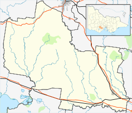
| Location | |||||||||||||
| LGA(s) | Golden Plains Shire | ||||||||||||
| State electorate(s) | Buninyong | ||||||||||||
| Federal Division(s) | Corangamite | ||||||||||||
| |||||||||||||
Steiglitz is a small town in Victoria, in the Brisbane Ranges. It is located 92 kilometres (57 mi) west of the state capital, Melbourne, Australia. In the early 1850s gold was found near the town, and as a consequence it grew on land belonging to pastoralists from the von Stieglitz family. Following the decline of the Australian gold rushes in the late 1870s the population of the town declined. The last gold mine in the town closed in 1941 and the population as of 2015 is just Eight People. The Steiglitz Post Office's history closely follows the town's history: it opened on 15 March 1856 and closed in 1966.[1]
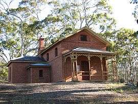
The former Steiglitz Court House is listed on the Victorian Heritage Register.[2]

Former Main Street which in colonial gold rush days saw shops, hotels, banks, mines and houses occupy both sides and surrounding streets. Building on bottom left is the former Scott's hotel. Further up the hill on the right is the former Ellis drapery.
References
- ↑ Premier Postal History, Post Office List, retrieved 2008-04-11
- ↑ "Former Steiglitz Court House (H1487)". Victorian Heritage Register. Heritage Victoria. Retrieved 7 July 2014.
External links
| Wikimedia Commons has media related to Steiglitz, Victoria. |
This article is issued from Wikipedia - version of the 8/4/2015. The text is available under the Creative Commons Attribution/Share Alike but additional terms may apply for the media files.