Sumapaz
| Sumapaz | |
|---|---|
| Locality of Bogotá | |
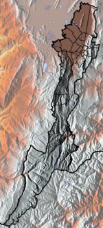
 Location of the locality in the Capital District of Bogotá | |
| Country |
|
| City | Bogotá D.C. |
| Area | |
| • Total | 780.96 km2 (301.53 sq mi) |
| Elevation | 3,500 m (11,500 ft) |
| Population (2007)[1] | |
| • Total | 5,667 |
| • Density | 7.3/km2 (19/sq mi) |
| Time zone | Colombia Standard Time (UTC-5) |
| Website | Official website |
Sumapaz is the 20th locality of Bogotá, capital of Colombia. It is the largest of Bogotá's 20 localities, beginning from the north at the edge of the urban frontier and running south to the Cundinamarca border with Meta and Huila. It is completely rural, with no city services.
History
The area was an important pilgrimage site for the Muisca indigenous people in pre-Columbian times, as the goddess Bachué was believed to be submerged in Lake Iguaque. In the 16th century, it was discovered by Nicolás de Federman on his journey to El Dorado.
It has been the stage for several rural conflicts, including those of 1928 and 1946. La Violencia of 1948 gave rise to the formation of the guerilla groups still present in Colombia. At the beginning of the 21st century, the Colombian army took the territory from guerilla hands as part of a counter-guerilla strategy of President Álvaro Uribe.
Economy
The population is dependent on small-scale farming and livestock.
General information
Borders
North: The localities of Usme and Ciudad Bolívar.
East: The municipalities of Une and Gutiérrez and the department of Meta.
South: The border of Cundinamarca and Huila departments.
West: The municipalities of Cabrera, Venecia, San Bernardo, Arbeláez, and Pasca.
Hydrology
Within the borders of the locality, several rivers are formed—mostly within Sumapaz National Park. The two largest rivers are the Pilar and Sumapaz, the latter emptying into the Magdalena River.
Points of interest
- Sumapaz National Park
- Ecoparque Chinauta
References
- ↑ (Spanish) Population 2007 - DANE
External links
- (Spanish) Video about Sumapaz
- (Spanish) National University of Colombia site about Sumapaz
 | Administrative subdivision in 19 localities |  | |
|---|---|---|---|
| Metropolitan Area | |||
| Geography | |||
| |||
Coordinates: 4°15′36″N 74°10′42″W / 4.26000°N 74.17833°W