Suba, Bogotá
| Suba | |
|---|---|
| Locality of Bogotá | |
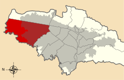 Location of the locality in the city of Bogotá | |
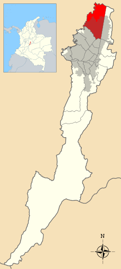 Location of the locality in the Capital District of Bogotá | |
| Country |
|
| City | Bogotá D.C. |
| Neighbourhoods |
List
|
| Area | |
| • Total | 100.56 km2 (38.83 sq mi) |
| Elevation | 2,700 m (8,900 ft) |
| Population (2015)[1] | |
| • Total | 1,161,500 |
| • Density | 12,000/km2 (30,000/sq mi) |
| Time zone | Colombia Standard Time (UTC-5) |
| Website | Official website |
Suba is the 11th locality of the Capital District of the Colombian capital city, Bogotá. Suba is located in the north of the city, bordering to the north the municipality of Chía in Cundinamarca Department, to the west the municipality of Cota, to the east the locality Usaquén and to the south the localities Engativá and Barrios Unidos.
Etymology
Suba is either derived from the Chibcha contraction Suba, meaning "Flower of the Sun" (uba = "fruit" or "flower", sua = "Sun", minus its last vowel, making it a possessive)[2] or from the words sua (Sun) and sie (water).[3]
Geography
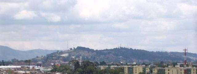
Suba has certain green areas mostly concentrated to the west of the locality, on the Hills of Suba and the Hills of La Conejera as well as the plains where urbanization has developed. Suba has become a residential area with small industrial and commercial zones located in the south of the locality. It is also crossed by a small mountain range that includes the hills of Suba and La Conejera separating Suba in two areas; the eastern side being more integrated to the urban area of Bogota.
The locality borders the Bogotá River to the northwest and borders at the 220th Street the municipality of Chia. To the south, the Juan Amarillo River and the 100th Street form the boundary with the localities of Engativá and Barrios Unidos. The eastern limit is the Autopista Norte with the locality of Usaquén and to the west, the Bogotá River forms the boundary with the municipality of Cota.
Besides the Bogota and Juan Amarillo rivers the locality of Suba is covered by other streams and wetlands like the Torca wetland, Guaymaral, La Conejera, Córdoba and the Tibabuyes wetland.
Transport
The Suba Avenue is the main road of Suba and the one that connects eastern with western Suba. Other major streets include the City of Cali Avenue to the west and the Autopista Norte to the east.
Since April 29, 2006, the mass-transit system TransMilenio covers the area throughout the Autopista Norte with its "B Line"; Portal del Norte, Toberín, Cardio Infantil, Mazurén, Calle 146, Calle 142, Alcalá, Prado, Calle 127, Pepe Sierra, Calle 106 and Avenida Suba with its "C Line"; Portal de Suba, La Campiña, Suba-Transversal 91, 21 Ángeles, Gratamira, Suba-Boyacá Avenue, Niza Calle 127, Humedal Córdoba, Shaio, Puente Largo, Suba Calle 100, Suba Calle 95, Rionegro and San Martín.
Other avenues like Boyacá Avenue, Ciudad de Cali Avenue, 134th and 170th Street are serviced by regular bus companies. There is also an inter-municipal highway that connects the locality of Suba with the municipality of Cota in the department of Cundinamarca.
Economy
The main economic activity of Suba relies on the cultivation of export quality flowers, services and commerce, specially of large shopping centers like Bulevar Niza, Centro Suba, Plaza Imperial and Centro Comercial Santa Fé.
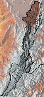
Territorial subdivision
Suba is formed by a Regional Forest Reserve Zone, called La Conejera, located in the western part of the locality and 12 Units of Zone Planning (Unidades de Planeamiento Zonal, UPZ) which are: La Academia, Guaymaral, San José de Bavaria, Britalia, El Prado, La Alhambra, La Floresta, Niza, Casablanca, Suba centro, El Rincón and Tibabuyes.
History
During the last Pleistocene glacial, the climate in the region of Suba gave rise to a páramo and Andean forest. Since approximately 12,000 years BP, groups of hunter-gatherers inhabited the area. Around 3500 BC, the people began to domesticate animals, cultivate crops and create arts and crafts. By 500 BC, maize and potatoes were the predominant products cultivated and by the year 800 the Muisca inhabited the area. After the Spanish conquest of the Muisca, in 1538, the Muisca were preserved in a Resguardo, located in the area of Suba and to the north in Chía and Cota. In 1550, Antonio Días Cardoso and Hernán Camilo Monsilva founded the village of Suba.
On June 22, 1850, the Resguardo of the Muisca in Suba was closed and the indigenous peoples forced away from the urban areas. This process continued until the year 1877.
On November 16, 1875, Suba was declared a territory free of indigenous peoples and became a satellite municipality of Bogotá. It became a municipality by decree during the Sovereign State of Cundinamarca. The rural area then was divided into landlords and peasants.
In 1954 the municipality was formally annexed to the "Special District of Bogotá" during the dictatorship of Gustavo Rojas Pinilla while still keeping its municipality status. In 1977 it became a minor cityhall of Bogota and in 1991 Suba was elevated to a locality of the renamed Capital District.
In 1990 the indigenous peoples of Suba and their towns were legally recognized by the government and ratified in the Colombian Constitution of 1991. In 1992 and 2001 the Cabildo Muisca of Suba and the Cabildo Muisca of Bosa respectively were legally recognized in an official ceremony with the participation of the then Mayor of Bogotá Antanas Mockus as estipulated in the Law 89 of 1890 and after more than a century without legal existence, it was also ratified in 2005.[4]
Indigenous population
According to the numbers provided by the respective Cabildos, the Muisca population of Suba is estimated to be of 5186 people. The following are the indigenous last names with their origin in Suba: Niviayo, Bulla, Cabiativa, Caita, Nivia, Chisaba, Muzuzu, Neuque, Yopasá, Quinche.
Sites of interest
- Suba Hills and La Conejera Hills
- Wetlands of Córdoba, Juan Amarillo and La Conejera
- Headquarters of the indigenous peoples Cabildo
- Central Park of Suba
- Viewpoint of Los Nevados
Neighbourhoods and veredas
Southeastern neighborhoods
The southeastern zone includes the sectors of Niza, Las Villas and Bulevar. The neighborhoods of Andes, La Floresta, Puente Largo, Pontevedra, Santa Rosa, San Nicolás, Morato, La Alhambra, Malibú, Recreo de los Frayles, Batán, Niza, Córdoba, Las Villas, Calatrava, Casablanca, Colina Campestre, Prado Veraniego and Mazurén.
Northeastern neighborhoods
The northeastern zone includes the neighborhoods of San José de Bavaria, Del Monte, Granada Norte, Villa del Prado, Nueva Zelandia, Santa Catalina, Mirandela, Vilanova, Guicaní and San Pedro.
Southwestern neighborhoods
The southwestern neighborhoods include the sector of main Suba; The neighborhoods of Suba, La Campiña, Pinares, Tuna baja, La pradera, Nuevo Suba, Aures 1 and Aures 2, Alcaparros, Cataluña, Costa Azul, Lagos de Suba, Corinto, El Laguito Villa Maria, La Chucua Norte, El Rosal de Suba, El Rincón, El Rubí, Bilbao, Fontanar del Río, La Gaitana, Tibabuyes, Lisboa, Berlín and Villa Cindy, Sabana de Tibabuyes.
Northwestern neighbourhoods
In the north, there is the sector of Guaymaral, to the northeast La Academia and to the west the sector of Corpas which has a clinic of the same name. This also includes the numerous veredas where the export quality flowers are cultivated, primarily on the highway to the town of Cota, near the Marshall Sucre Military School (Spanish: Colegio Militar Mariscal Sucre).
References
- ↑ (Spanish) Population 2007 - DANE
- ↑ (Spanish) Etymology Suba
- ↑ (Spanish) Etymology localities of Bogotá
- ↑ (Spanish) ratificado
External links
| Wikimedia Commons has media related to Suba (Bogotá). |
-
 Northwest Bogotá travel guide from Wikivoyage
 - (Spanish) National University of Colombia; Suba
- (Spanish) Neighborhood Information Unit of Suba
- (Spanish) Secretary of District Government; Suba
- (Spanish) Colnodo; Suba
- (Spanish) Noticias desde los Barrios de Suba, Bogotá
Coordinates: 4°44′28″N 74°05′02″W / 4.741°N 74.084°W
 | Administrative subdivision in 19 localities | 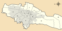 | |
|---|---|---|---|
| Metropolitan Area | |||
| Geography | |||
| |||